This morning dawned clear and chilly, with the temperature at 50˚ when I headed toward Lovell at 7:15. After placing some “Land Trust Walk Today” signs in pre-planned positions, I headed to the dam on Harbor Road in Fryeburg to wait for a ride.

Water flowed over the tiered dam, which was built in the early to mid 1900s at the request of the Pepperell Manufacturing Company in Biddeford. The townspeople contested its existence for it would raise the water level on Kezar Lake, but the textile mill located many miles away on the Saco River won the rights to construct such at the site of an 1800s saw & gristmill. Thankfully, though it did raise the level of the lake water, not all of the predicted problems came to pass.

The dam was our intended take-out for today’s paddle co-sponsored by the Greater Lovell Land Trust and Upper Saco Valley Land Trust. Though it’s located off Harbor Road in Fryeburg, it’s owned by the Town of Lovell. No longer used, it still serves to provide a historic reference. And a great place to either portage and continue on to the Old Course of the Saco River and then the “new” course, or take out as we intended to do.

While I waited, I poked around, and rejoiced in the sight of trees that like wet feet. High above the dam, the leaves of a silver maple shown brilliantly in the morning light.

Other leaves also caught my attention for their coloration–with veins of red interrupting their olive greenness. Green ash, another tree that likes wet feet but isn’t as abundant as its siblings, white and black ash, also stood tall beside the dam.

My dam-side exploration ended a few minutes later when Jesse Wright of Upper Saco Valley Land Trust and her friend, Shareen, pulled into the landing. We hoisted my kayak onto her already laden truck and found our way over the bumpy road to our intended put-in at a private residence–thanks to the generosity of its owners. Slowly the number of boats increased by the water’s edge as twenty-plus folks joined us.

Once all had gathered, Jesse showed off the map of our intended paddle, the red dots indicating our path from beginning to end, and I shared a bit of information about the fen, a GLLT property purchased in 2005. Today, the symbolic boundary between the two land trusts disappeared as we ventured off together.

It takes good neighbors and lake stewards to pull off such an event, and the Wurms are such. They helped us arrange the put-in, gathered a couple of canoes for several paddlers and took photos at the start.

Linda’s view included Jesse heading off as our lead,

and the rainbow of colors once we hit the water.

It took us a wee bit of time to get all the boats onto the lake, but it wasn’t a day made for rushing. And once in the sun, we began to warm up.

Before we headed off, we gave thanks to Linda (and Remy).

We also thanked Heinrich, who drew our attention skyward . . .

as he flew a drone above us.

Our first destination was to paddle north for the view.

The drone spied the mountains before we did.

And spotted our intended course . . .

into the fen.

A quick turn-around from the water gave us bearings as we noted the Baldfaces to the west.

We circled an island that serves as an environmental study plot for the US Forest Service and then paddled southward.

Jesse led the way through the pickerelweed.

As we followed, the view got better and better.
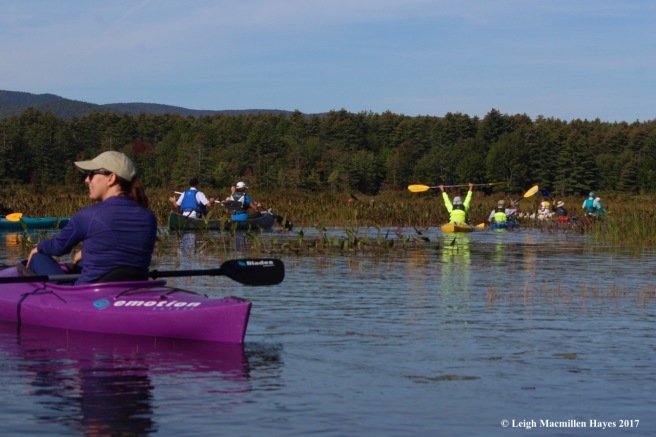
Acting as sweep, I took up the rear while the group snaked along.

We followed the twists and turns of the water trail, where red maples showed off their autumn display from the canopy.

Occasional leaves fluttered down, begging to be noticed in their singularity.

Though we didn’t get out of our boats and actually walk into the fen, we did stop to chat about what it had to offer. The GLLT owns 260 acres of the 500-acre fen, an acidic ecosystem with a deep layer of organic material including peat moss atop a sandy substrate. Several bird species of concern breed or hunt in the fen, including American bitterns and Sandhill cranes, the latter of which we had the good fortune to hear but not see. Long’s bullrush, a globally rare sedge, also grows here. But the crème de la crème for many are the cranberries. Folks on today’s paddle weren’t familiar with the plant and I couldn’t show them at the time, but I shared with them the experience of picking in the past with students from Molly Ockett Middle School in Fryeburg.

On a fall day each year, about thirty students in the school’s MESA program (Maine Environmental Science Academy–an experiential place-based curriculum for 6-8 grades) visit the fen with the GLLT’s Executive Director, Tom Henderson.

They learn about the hydrology of this place, but one of their highlights is to pick cranberries, and to that end, they become very possessive. As one student approaches another, a common statement is shared: “Don’t come over here. There aren’t any cranberries here.”

Over the course of several hours, they fill their bags and sometimes even show off their creative talents in other ways–all in celebration of the cranberries.

Continuing along the river this morning, we noted beaver activity and talked about scent mounds and their usefulness within the beaver community. And then we reached the fish screen. Jesse had paddled the course last Sunday and made it under the screen without any issues.

Since then, the beavers had been busy damming it up. One of our members worked to adjust some of the branches so we could all get through.

Of course, sometimes a helping paddle was needed to push a boat forward.

While we took turns, our efforts didn’t go unnoticed.

On the other side, a ruler indicated depth.

And then, and then, in what seemed like only minutes but was actually a couple of hours filled with camaraderie between familiar friends and new, plus a touch of natural history thrown into the discussion, we found ourselves at the bridge and the end of the journey for some. Others chose to paddle back rather than hitch a ride. We had come full circle.
As we pulled boats out, we were surprised at how warm it was since we were out of the shade, the temp having reached into the 80˚s.
Our outing on the Kezar Lake Outlet would not have been doable without Jesse Wright, who did the yeoman’s work of pulling it together, William Abbott, USVLT’s executive director who created the map, the Wurms and their neighbors who contributed land, boats, photographs and time, and all who ventured with us on this most lovely first full day of autumn. Thank you all.

Great job organizing and kudos to USVLT for an enthusiastic crowd of paddlers!
LikeLiked by 1 person
Yes, they are known for their paddles. Many thanks again for all that you and Linda do–on so many levels.
LikeLike
Wonderful outing. Is this something that others might do on their own?
LikeLiked by 1 person
Others could do this, Watson. You might consider putting in at the outlet dam on Harbor Road and traveling upstream to the lake and then following the same route back. Or you can put in at the public boat launch off of West Lovell Road–it’s on Town Beach Road just after the Narrows bridge and Loon’s Nest Restaurant. If you put in there, head to the right, pass under the bridge and then you’ll need to work your way around or across the Lower Bay.
LikeLiked by 1 person
Tried it find the Outlet today, but turned the wrong direction from the boat ramp, then turned around, went binder the bridge and almost got to the outlet. However, the sun was setting! Did I care? No, indeed. The two hours on Kezar in weather like today was pure pleasure. Thanks for the prompt.
LikeLiked by 1 person
Ahhhh. Saw your photos and wondered. So glad you enjoyed the experience. And the fen will still be there on another day.
LikeLike
Almost made it. I think that to do what your party did would take most of a day launching from the Narrows.
LikeLiked by 1 person
Might be easier to launch from the dam and travel upstream and then return the same way. If you do that, don’t forget the fish screen, where you can portage if the beavers have been at work.
LikeLike