Happy 6th Birthday, wondermyway

It’s hard to believe that six years ago I gave birth to wondermyway as a means to record the natural world and all I met along the way.

There’s no need in reminding everyone that since last February it has been quite a year, but I have to say that I’m especially grateful to live where I do, in a place where I CAN wander and wonder on a regular basis.

As I look back through posts of these expeditions, I realize how often nature presents itself in such a way that moments of awe make everything else going on in the world seem so foreign. If only everyone could whisper to a dragonfly upon his or her hand; watch a cicada emerge from its larval form; and even appreciate a snake or two or three.

Join me for a look back at some of my favorite natural encounters of the past year. If you want to remember a particular adventure, click the titled link below each photo.

Transitioning With My Neighbors:

From sun to rain to sleet and even snow, it’s been a weekend of weather events. And like so many across the globe, I’m spending lots of time outdoors, in the midst of warm rays and raw mists.

I’m fortunate in that I live in a spot where the great beyond is just that–great . . . and beyond most people’s reach. By the same token, it’s the most crowded place on Earth right now.

We’re all in transition, my neighbors and me. What the future holds, we know not. The best we can do is hope we come out on the other side–changed by the experience, of course.

Under the Bubbles

Wander outdoors if you can and let the anomalies pull you into their realm. I promise, your eyes and your mind will be opened to so many wonders that you’ll resist the urge to move along for so enamored will you be by your finds. Slow down and look and be wowed.

In the end, may it not be an end. May it be a beginning. May you live under the bubbles and give thanks that your bubble is attached to so many others as you share a brain.

Dragonfly Whisperer Whispers

We had no intention of eating lunch in this spot today, but while looking for a mountain to climb, we kept encountering full parking lots and so our backroad meander put us beside a bog at lunch time and voilà, we managed to walk all of less than two tenths of a mile. Total.

But in that short distance, our eyes feasted. First it was all the Painted Turtles basking in the sun. And birds. And dragonflies.

I just had to find out. Would he or wouldn’t he? He would and did. Yes, I quietly placed my finger on the leaf and he climbed aboard, then struck a rather relaxed pose. The Dragonfly Whisperer whispers once more.

Marvels of the Meadow

“My lupine meadow is in full glory!” a friend wrote in an e-mail. And she encouraged visitations. So . . . I went. Actually, we went, for I invited another friend to join me.

Fortunately, I guess, though unfortunately on some levels, we pulled ourselves away by mid-afternoon. But our bug eyes were wide open. In the end, we offered up thanks to our hosts, Linda and Heinrich, for inviting us to enjoy the full glory of their lupines and all the marvels of the meadow.

Celebrating Cemetery Cicadas

Beings who once walked the Earth
support new life as summer's serenade
begins to take shape 
upon stones that memorialize the past...

On this summer day, hollow cast(ket)s left behind
provide a memory of vulnerable forms.
From soft pastel bodies to wide-faced creatures with bulging eyes,
I get to celebrate cemetery cicadas. 

Frog Alley

I’m pretty sure I said to the friend whom I met on the dirt road that I never see frogs there except for the painted boulder that has faded with age and I no longer even think to honor with a photograph.

But still, she reminded me, “I’m sure we’ll see something interesting.”

No way.

After walking one stretch of the road and only pausing a few times in the hot sun, we hopped back into our vehicles and made our way to a much more shaded location. As we stepped toward the river, in flew a Kingfisher. And we knew we were in for a treat or two or three.

Crowning Glory

The theme of the week didn’t dawn on me immediately, but a few days into it and I knew how blessed I am.

It was a week for me to realize how important all the young people in my life are from our sons whom I can chat with on the phone to those who have chosen to make this area of western Maine their home and to get to know their place in it. And then to go beyond and share it in a way that benefits the wider community.

Thank you, Hadley, for the opportunity to celebrate your birthday. And thank you Rhyan, Parker, Dan, Jon, Mary, Brent, and Alanna: it’s my utmost pleasure to share the trail with you whenever we can. And to know that the future is in your capable hands.

We are all blessed. Today we crowed Hadley, and in so doing, gloried so many others.

Making Sense of Scents

Last week, while walking along a trail I later intended to share with some local kids, a subtle movement caught my attention.

About two thirds of the way along the trail, exactly where I’d spied it two hours prior, the Garter Snake still posed. And the kids got to examine it. And wonder. And exclaim. They went in for a close-up look, thus the snake stuck out its tongue repeatedly in an attempt to get a better sense of who or what might be in its midst.

Snakes have poor eyesight and their hearing ability is limited. Thus they use their nostrils and tongues to pick up scents of prey or predator. By flicking the tongue, they collect odors that the forked prongs relay to two holes in the roof of their mouths, aka Jacobson’s organ. With information transferred from the organ to the brain, they can interpret scents.

For the kids and me, it was this sense: Best. Moment. Of. The. Afternoon.

For the snake: it decided we weren’t worth getting excited about as it made sense of our scents.

All In A Day’s Walk

My mission was two-fold. Hike up a small mountain and capture a one minute video to post on a work website next week, and retrieve a game camera so we can download the photos and then place in a different location.

First there was the porcupine den, then a beaver tree, and along the way a fungi.

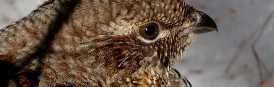
My final sighting of the day, that still has me smiling, occurred in the middle of the adventure, but I wanted to save it for last. Do you see what I saw?

Who cooks for me? I wish this Barred Owl would, for I must now prepare dinner. But that’s okay because I’ll take him with into the kitchen in spirit and give thanks that I had the opportunity to spend a few minutes with him . . . all in a day’s work.

My Heart Pines

Fourteen months ago I wrote Ode to Pinus Strobus, showing my respect for the mighty pines that inhabit our woods. Curiously, it was a rainy day then. And today dawned the same, though even more curiously, today we turned the calendar to December 1, yet the temperature rose to 57˚, like a summer day as we approach winter in western Maine. Because of the temp, the day offered some incredible wonders.

For those who love to wander and wonder, I hope you’ll be still and have an experience similar to what this tree offered me today.

My heart pines . . . naturally.

Sharp Observation

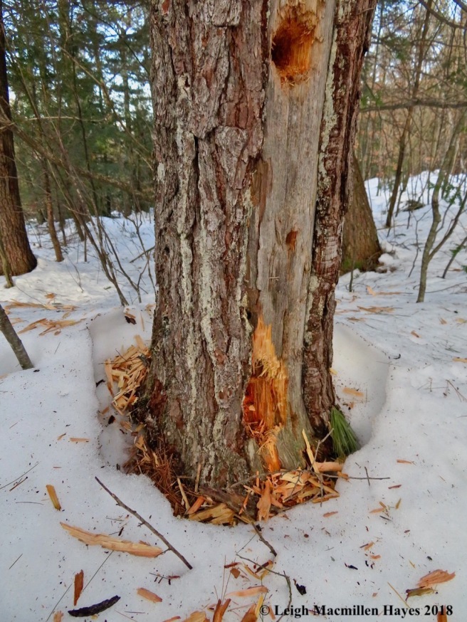
I was early–a rare occasion as usually I’m the one who arrives at least ten minutes after the agreed upon time. It wasn’t always that way, but has become a bad habit. That said, it was a creature of habit that I went in search of because I had some time to spare.

He was up there enjoying the cambium layer of the bark as witnessed by the goldeny color of the branch by his feet. All those downed twigs–apparently they were in his way so he nipped them off and dropped them to the ground in order to get to the nutrients he sought for his winter diet.

Check out his eye. We were both sharp observers as we eyed each other from a distance.

Ghost of the North Woods

For almost thirty years I’ve roamed this particular wood and for the most part you’ve eluded me.

After finding so many signs year after year, today . . . today I spied an uprooted tree at the very spot I thought might be a good place to stop and spend a few hours in silence. As I made plans to do such in the near future, the tree moved.

And transformed into you!

When at last you and your youngster departed, despite your sizes, it was as if you walked through the forest in silence. My every move comes with a sound like a bull in a china shop, but you . . . Alces alces, you weigh over one thousand pounds, stand six feet at your shoulder, and move through the forest like a ghost. For that reason and because you let me spend some time with you today, February 11 will henceforth mark the day that I celebrate the Ghost of the North Woods.

Thank you to all who have joined me for any or all of these journeys. With each learning or sighting, I get excited and can’t wait to share it with you. I’m not only grateful to be able to wander and wonder, but I’m also thankful for all of you who take the time to read these posts.

Funky Mondate

It seems like it’s been forever since my guy and I shared a Mondate, but truth be told we snuck away to Diana’s Bath and beyond in Bartlett, New Hampshire, a week ago and here’s a sneak peek.

We’d had snow two days prior and the lower falls of Lucy Brook showed off the force that the Lucy family had harnessed in the late 1800s to operate a saw mill.

Remnants of the mill’s foundations still exist.

Fortunately, the falls are watched over by fairy-sized snow people.

Stopping by the Upper Falls, we had memories of ice discs spinning counterclockwise, but they remained just that: memories from a Romancing the Stone Mondate two years ago. Last week, the temp was not quite as frigid so no discs formed.

Despite that, we hiked on for a couple of miles and eventually turned around to retrace our steps.

Fast forward to today and we headed off to explore two land trust properties in western Maine, the first of which we’d never traversed before. My extreme excitement upon arriving at the first was to learn that an outermost trail was named for G. Howard Dyer.

I had the pleasure of knowing Howard, who died at age 103 in 2009, when he lived at a local assisted living home where my mom also resided. He was an independent Mainer who drove a car into his late 90s and I remember his license plate: GHD. To me, it read: GOD. He’d turn into the home’s parking lot practically on two wheels, and though the old car had some dings, somehow Howard’s adventures weren’t thwarted by his age, maybe because he was GOD.

At the time that Mom lived in the same home, I volunteered to help the Activities Director one day a week and one of the things I did besides arts and crafts was create a monthly newsletter filled with recipes, poetry, songs and memories of yesteryear that the residents shared with me.

For one issue, I spent some time interviewing Howard about his life and experiences. He was a great storyteller and shared with me that over the years he’d lived in Otisfield on and off. Knowing that state law required perambulation of the town’s boundaries, in 1946 he conducted his first walk about town. Fifty-six years later, in 2002, he knew that no one had walked the boundaries in a long time. So, at 95 years of age, he decided to do it again. “Weren’t sure I could do it,” Howard told me as his eyes twinkled. “Didn’t say it to anybody.”

It took him months to complete because he’d walk here today, there tomorrow. When he finally finished the job, he told town officials. As Howard told it, they were surprised because they couldn’t get anyone to do it due to “swamps and all, you know.”

Howard’s accomplishments were included on the 2002-2004 House Appendix of the Legislative Record when he received Otisfield’s Boston Cane. “Town law required perambulation of the boundaries every ten years, and as a gift to the town, Mr. Dyer walked the 34-mile Town of Otisfield’s boundary line, once at the age of 39 and more recently at the age of 95.”

He was quite a guy and actually ten or more years ago my guy and I decided to follow his example and perambulated the boundary of our town, a section this Monday, another section the next Monday, taking a year to connect all the dots.

I was thrilled to see that Howard had been honored by having a trail named for him, and suggested to my guy that perhaps we need to consider repeating our perambulation. To which he readily agreed.

For today, however, we had other things to notice, and lately it seems no hike is complete unless a Winter Firefly can be found.

There were other insects burrowed in place and they shall remain nameless because I didn’t want to expose them any more than they already were.

My learning continued as we journeyed on and we were almost finished exploring Howard’s trail when I spied an oval shaped sawfly cocoon on a Northern Red Oak twig.

But it was the cluster of cocoons at the end of the twig that deserved even more attention. I’m 95% certain (until someone tells me otherwise) that this is the random formation of a parasitic bracinoid wasp cocoon. The question remains: who died so this structure could be created? Because that’s what these wasps do–parasitize other insects by laying their eggs upon them.

We soon left Howard’s Trail behind and moved on to tramp along another trail, where a White Oak pulled me in because the salmon color and rounded edge of the leaves always stops me in my tracks.

Because I stepped in for a closer look, the sapling honored me with the offering of what I think is an old Wooly Sower Gall, which I believe only has a relationship with this species. When first formed, it would have consisted of white wool highlighted with pink spots, but apparently it takes several years for the larvae to mature and the structure develops “horns” over time.

Lest you think I have been ignoring mammals to focus on insects, never fear–I delighted with the discovery of a large cache/midden created by a Red Squirrel.

Our journey took us beside a river that follows a crooked course through the landscape, but what always amazes me is the erosion along the edge. For how much longer will this tree stand?

As we stood on the edge ten to fifteen feet above the river, we had to wonder–how high does it get that the bank should be so eroded at this height? We never seem to visit in late winter, but maybe this year we should. Though given the current lack of precipitation, maybe this isn’t the year to gain a baseline understanding.

At last we reached the trail end, and knew it was time to turn toward home.

It had been a successful day, coming unexpectedly upon the trail named for Howard and my guy locating a winter geocache that wasn’t really a winter geocache for he had to dig through some snow to find it and the snow isn’t at all deep. Yet.

We also discovered an impressive hollowed out tree through which we just had to chat. If I were a bear in the woods . . . this would be my den. Note to self: if you ever need an out-of-the-way place to rest, remember this spot.

And we found a fun key hanging from a tree, adding icing to our funky Mondate.

Frog Alley

I’m pretty sure I said to the friend whom I met on the dirt road that I never see frogs there except for the painted boulder that has faded with age and I no longer even think to honor with a photograph.

But still, she reminded me, “I’m sure we’ll see something interesting.”

No way.

After walking one stretch of the road and only pausing a few times in the hot sun, we hopped back into our vehicles and made our way to a much more shaded location. As we stepped toward the river, in flew a Kingfisher. And we knew we were in for a treat or two or three . . .

But first, we had to explore the structure that has spanned the river for 163 years: Hemlock Covered Bridge. My friend is a history buff and I’m a wanna-be so it was apropos that we should take our time as we walked across–pausing to look and wonder as frequently as when we’re on a path.

I first saw this relic of the past years ago when I canoed up the Old Course of the Saco River with a group of tweens whom I took on weekly adventures when my summer job was as Laconia YMCA’s Summer Camp Director. In those days, one could get permission to camp by the bridge. Things have changed and that land is now posted with No Trespassing signs.

The bridge is a woodworking masterpiece and a symbol of the pioneering spirit of the 19th Century. In this 21st Century, there are others who also have a pioneering spirit and create their own masterpieces within.

Built of Paddleford truss construction with supporting laminated wooden arches, Hemlock Bridge is one of the few remaining covered bridges still in its original position. Peter Paddleford of Littleton, New Hampshire, created this design by replacing the counter braces of the Long-style truss bridge, creating an unusually strong and rigid structure.

Though reinforced in 1988 so you can still drive across, it’s more fun to walk. As we did we took time to admire the work of our forefathers,

peer at the river,

and read the carved messages on Maine’s oldest remaining covered bridge.

It was designated as a Maine Historic Civil Engineering Landmark by the American Society of Civil Engineers on January 17, 2002. I’m not sure what happened in 1922, but obviously it was another date to note.

Originally there were 120 covered bridges which spanned rivers throughout Maine. Covers or houses were constructed to protect the wooden span from the weather.

They were also places where travelers and animals could seek refuge from a storm, or lovers could sneak a kiss. Six of the remaining nine in Maine are located in the Lakes and Mountains Region.

We admired every facet of the bridge for moments on end, and then made our way to the river’s edge, where Slaty Blue Skimmers continued to dance. But as is their habit, this one kept landing on the same broken branch. Eventually, I coaxed it onto my finger, but then a sweetheart zipped by and he was off, hoping to sneak a kiss of his own making.

Next, our attention focused on a bullfrog. A huge bullfrog.

Two little Green Frogs were focused on the same and remained as still as possible in hopes of not attracting Mrs. Bully’s attention.

She at last began to move and her forward motion was slower than either of us have ever witnessed. We watched as she slithered forth one frog leg length at a time.

At last she reached a destination and paused. Was she hiding from us? Had she slithered like a snake in hopes we wouldn’t see her? Or did she have her eyes on a meal?

We’ll never know for a rare treat suddenly flew onto the branch where Slaty Blue had posed time and again. Meet a Dragonhunter. This huge clubtail dragonfly is known to eat butterflies and even other dragonflies. Thank goodness Slaty Blue had moved on.

Suddenly it was time for us to move on as well, but not before spying one more frog–this one a small Pickerel with sets of dark rectangles decorating its coppery-colored body.

With that, before my friend and I bid adieu, I had to eat my words that there are no frogs on Frog Alley. But technically, we weren’t on Frog Alley, but rather Hemlock Bridge Road. Still, the two are connected and we gave thanks for the chance to honor the past and wonder about the present in this locale.

Grateful For Your Company

Oh my goodness, oh my goodness, oh my goodness. Today’s hike found me traveling solo, as is the norm in this current time, but I took each and every one of you along with me because so excited was I by all of our finds.

We began at parking lot #5 of Greater Lovell Land Trust’s Heald and Bradley Ponds Reserve.

As I showed you in the parking lot, our plan was to begin on the Roger’s Family Trail and then circle around on the orange Heritage Loop Trail with a side trip to the summit of Amos Mountain in the midst of the journey. You all agreed that it sounded like a great plan.

I had previously warned you that part of the route could be a bit wet and was pleased to see that some of you had remembered to don your rubber boots, but those who forgot managed to find a way around. I trust no one had wet feet by the time we finished. Was my assumption correct?

Of course, I love water and so before we crossed over the bridge, I insisted that we take a look and try to spy tracks in some mud or aquatic insects or plants springing forth.

Bingo on the latter and we all rejoiced at the sight of False Hellebore with its corrugated leaves so green.

Finally, after poking about for a bit, I suggested we move along. It seemed like we managed to walk about five steps and then something would catch our attention and all forward motion came to pause. But that’s the way we like it for we notice so much with such slow movement. Do you remember this spot? Where we paused to look for Trailing Arbutus buds and noticed Downy Rattlesnake Plaintain growing in a colony. And remember how I told you that the only way I can remember the common name of this latter species is because it doesn’t look “downy” to me.

As often happens, the trail enhanced the lesson for not too much further along we practically stepped on another family member, this one bearing the name Checkered. Really, had Mr. Linnaeus asked me, I would have switched it around for the dullness of these leaves seems more downy in my mind and the other more checkered. Alas . . . he didn’t ask.

By this point, we’d hit drier trail conditions, if you recall, as we started climbing uphill. Drier, but rockier, that is. And then upon one, we spied a little package that you knew would delight me. Fox scat, indeed. With a blunt end and even a twist. Classic fox scat.

It took us a while, but we managed to reach the intersection with the orange trail and turned to the left to proceed. It was there that we began to meet common polypody ferns. Some of you explained that you know it as rock cap fern or rock polypody fern. What we all know is that it’s most often found growing on rock surfaces in moist, shady woods.

I did hear the hushed groans when I turned it over, but what could I say? I can’t resist checking to look at the underside. Like little pompoms, the organs or sori that housed the dust-sized spores or sporangia are arranged so neatly in two rows upon each leaflet. In their old age, the sori of these common polypody are orange-brown.

You, however, were eager to move on and so we did. Until we didn’t. For we stopped once again at “El Pupito,” the pulpit rock.

And did what one should do at the pulpit–honor the view through nature’s stained-glass window.

Oh yeah, and on the back of the boulder, you knew the minute you saw it what was going to happen next.

Out came my water bottle as I sacrificed some H20. But really, you are also equally amazed each time the magic happens and the greenish color of algae on rock tripe lichen makes itself known.

I saw a few of you gawk.

With a snap of our fingers and twitch of our noses (no we didn’t touch our fingers to our faces), we soon made it to the summit of Amos.

It was there that while zooming in to note the glorious red maple buds we spied another in the form of a spider. And we all took a closer look, one at a time, of course, allowing for six feet of space.

Then we backtracked down to where the blue trail met the orange trail and continued on the orange. That is . . . until sweet bird songs stopped us in our steps.

The trills lasted a few seconds and began again.

Most of us couldn’t recall who it was and gave great thanks to have Peter and Joe along for a positive ID: Pine Warbler indeed.

At our next stop I was so sure that one of you would provide a definitive answer to the structure’s use and history, but you only asked more questions to which I didn’t have the answers and so it shall remain a mystery. Who built it? Why? What? When? We do know the where and have some ideas about the how, but can’t quite respond to the Five Ws and an H in a complete manner.

And so we left there and moved on to the spot where we chatted about all the ghoulies and ghosties and long-leggity beasties that seemingly followed us through the woods.

Each time we heard a sound from one of the above, if it wasn’t a dried leaf blowing across the forest floor, it turned out to be a chipmunk. Why is it, we wondered together, that they can be so still one moment, but in the next insist upon calling attention to their presence?

Moving along, we eventually crossed over the wall and onto what was once the property of Amos Andrews.

Here, only a few years ago, one among us, yes Alice, that would be you, realized that in this spot grew white oak, a tree that we had previously believed no longer grew in these parts given its use in barrel making and other purposes. That is, until we recognized the chunky blocks of bark that helped to negate that assumption.

The leaves below also defined the new story, with red oak’s bristly pointed lobes on the left and white oak’s rounded lobes to the right.

As it would be, we realized we weren’t the only ones looking. And again, we had to take turns getting close to ohh and ahh at the alternating light and dark markings on the abdomen’s edge, legs and antennae of the Brown Marmorated Stink Bug. Okay, so we know these beasts inflect considerable damage to some fruits and crops, and can be a nuisance when it takes shelter in our homes, but still.

Around the corner from the oak tree we paused beside the homestead of Amos Andrews and wandered about his walled property for a bit, each of us trying to answer the question, “What was Amos thinking?” We haven’t answered it yet, but time will tell as perhaps more understandings will be revealed.

Down the former road we walked, grateful that being two rod wide, (a rod at 16.5 feet), we had plenty of room to spread out.

At the intersection with the Amos Mountain Trail, our route crossed over and we continued on to the lookout point where the Balds to the left, Mount Washington a wee white pyramid in the background, and Kezar Lake below held our focus.

And then we began to retrace our steps, back toward the parking lot where we’d first gathered. But there were two more things to notice, the first being a skeleton of a paper birch, its roots till seemingly intact.

And finally, water striders not doing a very good job of practicing social distancing.

We, on the other hand, had nailed that one, for while you all walked with me, I was alone. And ever so grateful for your company.

Because of the Hare

Yesterday’s torrential rain, sleet, torrential rain, snow, sleet, torrential rain, snow, wind, and cold became today’s frozen snow upon which I could walk without sinking.

Or wearing snowshoes, though I did choose micro-spikes because I wasn’t sure what conditions I might encounter as I headed out to the old cowpath and woods beyond.

It was at the far end of the path that a lot of disturbance drew my attention and I realized deer had pawed and pranced in an attempt to gain something upon which to dine.

Empty caps were all that had been left behind during the ungulates search for a meal fueled by Red Oaks.

A wee bit further, I paused by the vernal pool that will soon seek much of my attention. Today, it shared two things; yesterday’s weather had transformed it from a snowy crust to an icy one; and the neighborhood turkeys, which I’ve yet to see, had stopped by.

But my reason for heading out late this afternoon was to cross over the double-wide wall by the pool and disappear into the saplings that fill the space.

It’s a parcel of land that was nearly clearcut in its day, but since then I’ve welcomed the opportunity to watch forest succession and all that it has to offer in action.

Being an early succession forest, Gray Birch fills the landscape with its twigs atop triangular gray beards. Red Maples and White Pines add their own colors to this place.

At the gray birches’ feet, their catkins filled with fleur de lis scales and teeny tiny seeds that remind me of ever so minute insects with transparent wings, littered the snow. Two actual insects also made themselves known. Do you see them? (Faith and Sara–happy looking 😉 )

And then another insect came into my sight. Truth is, a friend introduced me to this pupal form of a ladybeetle in late autumn/early winter. Of course we’d never seen it before, but as happens in the natural world, once you see something and gain a wee bit of understanding about it, you suddenly see it everywhere. Until recently, everywhere for this species had been upon evergreen trees. And then we found it on tree bark. Gray Birch to start.

I had much to think about in terms of the ladybeetle, but really, I’d come to this place because of some downed trees. Here and there in this forest swath, trees are bent over for no apparent reason. I think I know the why for I don’t believe it’s because a storm came through or all the trees would have bent over. I suspect it has to do with the fact that so much of the plot consists of gray birch that topple easily with the weight of snow, such is their cell structure. And as they toppled, they took down some pine saplings in the mix.

The creator of this scat loves the forms that the downed trees created for it’s a great place to hide when predators or old ladies stop by on the hunt. What I wanted the critter to know was that I was only hunting with a camera. You see, last week I actually spied the scatter as it hopped out of the form and leaped away, its fur slightly streaked brown as is its manner in this between-season time, giving rise to one of its common names: varying hare. It was too fast for my camera and so today I went back in hopes of a second sighting.

By the angled cuts of surrounding vegetation, I’d knew where it had dined.

And by its track, I knew its most common name: Lobster Hare. Okay, so it’s a Snowshoe Hare, but each set of prints always reminds me of the crustaceans of Maine fame.

I tried, oh so hard, to stand still and hoped upon hope that the hare would show itself again.

In my standing still, I did see more ladybeetles in their pupating stage–this one upon a dead White Pine.

And near it . . . another set of downed trees creating another Snowshoe Hare form, that place where the lagomorphs rest during the day. Usually that place is located under evergreens as was the case.

Spying a certain set of prints by the form, I realized I wasn’t alone in my quest. Do you see the C-ridge between the toes? And the asymmetrical presentation of the two lead toes? And the impression of two feet, where a foot packed the sloshy snow of yesterday and a second foot landed in almost the same place? I present to you a Bobcat. 😉

It led me to yet another Snowshoe Hare form.

Atop the form were signs of life, much to my delight: prints, scat, and even the orange-red tint of Snowshoe Hare pee.

Still, the Bobcat moved–its track connecting with a run or well-traveled path of a hare.

Following the hare and cat tracks led to yet another “form.”

It was there that I stood for the longest time. And I swear I heard someone munching within. Was it my imagination? Probably. For my imagination also had me hearing all the wild animals of the forest closing in on the hare and me and then I realized that I was the one closing in on the hare and my “fear” was its “fear.” Marcescent leaves that rattled in the breeze and trees that moaned as they bent in the breeze became larger than life creatures of the forest.

As I stood and listened and felt the hairs on the back of my neck stand tall, I spied more ladybird beetles in their larval and pupal stage.

As much as I wanted to understand the life cycle of this beetle and especially how it deals, if it does, with our low winter temperatures, please, please don’t tell me your understanding.

From evergreen to hardwood, I’m in the process of learning the habitat of this species.

Heck, it not only doesn’t just use evergreens upon which to pupate, it also doesn’t depend only upon Gray Birch, given that it can be seen upon plenty of Red Maple tree trunks.

Oh, and as you look, others might surprise you like these puff balls, their spores still ready to pour forth when gently poked.

Over and over again as I waited patiently for the hare, the ladybeetles made themselves known.

Some presentations differed from others and made me wonder about their matter of timing. Were they frozen molts? Were they morphing? If you know the answer, please don’t tell for this is a new learning and I hope to stay on the case.

Still, as first discovered, there were more in the evergreens to spy.

As the sun began to set, I found the Bobcat track once again and it led into the forest beyond.

More importantly, I backtracked its trail and discovered yet another Snowshoe Hare form created by downed trees. In my mind, so many places for the hare to hide. So many places for the cat to explore. And in the mix–me.

I never did see the hare today. Or the deer. Or the turkey. Or the bobcat. But . . . by their signs I knew that we share this space and there were a few others in the mix including porcupines, squirrels and grouse, and I gave great thanks . . . because of the hare.

Tuesday Tracking is ON

I promised the Greater Lovell Land Trust‘s Tuesday Trackers that I’d let them know by 7am today if our adventure would actually take place because the forecasters were predicting a snow storm. We LOVE snow, but not when it ruins our plans.

And so at 6:43am, after checking various weather reports and TV stations for cancellations, whereupon I discovered that no school’s had cancelled, which seemed a sign that meant if the kids could go to school, we could go tracking, until I remembered that this is school vacation week and the kids weren’t going to school today anyway, I wrote to the 54-member group: “Weather reports state that the snow will start at 1pm in both Cumberland and Oxford Counties today, but in the hourly listing it shows snow showers at 10 and snow at 11.

I’m going to go for it in hopes that we can at least find some evidence of the porcupine and its visitors, but trust those of you who had intended to join me to make that old judgement call. Please don’t be afraid to back out.”

As usual, I told them that the plan would stay the same for those who had already told me they’d attend, unless, of course, they did decided to back out. None wrote to say they could not come. Three sent messages that they would join us.

Much to my delighted surprise, seventeen met at Heald and Bradley Ponds Reserve parking lot #1 at the far end of Heald Pond Road in Lovell as the snowflakes fell. It was 9:30am. Actually, I met some to carpool from the Charlotte Hobbs Memorial Library, and it was there that a few of us first noticed the flakes were falling–just after 9. Hmmm. 1:00pm?

But, this hearty crew didn’t care and after donning our snowshoes, onward we charged. Well, not exactly, for we pride ourselves in not getting far from the parking lot and then spending an hour looking and wondering. First, it was fox prints, and then a fisher that took us a while to figure out based on the clues because snow had filled in the indentations, but the pattern of the track and a few glimpses of toes helped us make a determination that was confirmed after we crossed the path of a more recent snowshoe hare, and seemed to follow the activity of a porcupine.

Like the scouts that we are, we spread out at times, each one or pair trying to notice the finer details. We were in a mixed forest in Maine, close to a summit with rocky ledges, yet near a wetland, stream and between two ponds. The overall pattern was important to notice. How was the critter moving across the landscape? And did its action change at some point? Were any finer details visible in a single print? Or a combination of prints?

Taking measurements was also important–extremely so for those prints that were a couple of days old and muted. Their shape and size and the pattern of their overall track helped, but the measurements cinched the case as we noted stride, especially for the direct walkers such as a red fox.

Ah, how did we know it was red and not gray? The measurement of its stride and straddle were spot on, but also by the scent it had left behind on saplings and rocks did we know it. A few of us got down to sniff–and we were not disappointed. Skunky musky is the odor of some fox urine, especially at this time of year when leaving a calling card with ones age, sex, and telephone number is of utmost importance.

Once you take a sniff, you never forget and know that the next time you smell that skunk in the middle of winter, you are actually in the presence, past or maybe present but watching you from a distant point, of a red fox.

We spent at least an hour with the parking lot still in view as we noted other tracks including squirrel, snowshoe hare and deer. And then we challenged ourselves–a climb to the summit to check on the porcupine den below. The snow was getting heavier and accumulating on our hats, but no one wanted to turn around.

Occasionally, we paused to catch our collective breath, happy were we to be out for this adventure. I did, of course, tell a few who were unfamiliar with the trail, that the summit was just up ahead. Um, I said that more than once. Twice. Three times. Maybe four.

But . . . it was soooo worth it. At the summit, we could see more porcupine tracks that were fresh either last night or the night before and a smattering of pine twigs that had been cut and dropped.

The angled cut of the twigs added to our knowledge bank: rodents make such cuts, called nip twigs. The twig is snipped then turned so the nutritious tender buds can be accessed; and then it is cast off, creating a “trash” pile below the feeding tree.

Bark had also been a point of the porky’s focus and we paused by saplings to wonder about the rodent’s ability to climb what struck us as the scampiest of trunks, but also to appreciate the indentations of its teeth.

While some stayed at the summit, others descended below in hopes of finding a den.

We knew we’d entered a Disney World of sorts, for everywhere we looked below the summit we saw signs of the porcupine’s adventures, including troughs leading from one potential feeding or den site to another.

Getting down wasn’t pretty, especially in one spot, but still no one gave up. Remember, this is a determined group.

Under the ledges, we stopped to check for mammal sign, curious to learn more about the story of these woods and rocks.

We weren’t disappointed. We never are. That may sound pompous, but it’s really one of wonder. When we focus, things are revealed and we are wowed. One of today’s wonders, bobcat scat. Three times over. Do you see the arrows that point to the deposits? And their segmented structure?

But . . . that wasn’t all. Despite the tricky climbing we had more to see.

It was a spot, however, where we needed to take turns given the conditions, and so while we waited, we noticed other things of interest, like the curled form of Common Polypody ferns curled up like Rhododendron leaves to indicate the cold temps–nature’s thermometers. Did I say the name of the shrub began with an M? R? M? They’re close in the alphabet. 😉 (Some of you will chuckle to know that it was my guy I turned to for the shrub’s name–I was still stuck on M)

R or M? In the end it doesn’t matter. But do check out those double rows of orange sori, clusters of spore-producing organs on the fern’s underside.

Rock tripe (which for once I didn’t pour water upon to perform a magic trick) and icicles also garnered our attention.

But . . . it was the actual porcupine den and its juxtaposition with granite and evergreen ferns and snow that tickled our fancy.

Can you see the scat, prolific in nature?

With so much, including lots of fresh deposits, we wondered if we might be disturbing the local resident. And so when our friends who’d stay at the summit yelled down to ask if we when we were going to ascend, we knew the time had come.

Back at the summit, most of us posed. Can you see Mount Washington in the background? No, we couldn’t either.

Closer to the parking lot, we posed again, before heading off on snow-covered roads to reach our homes.

It’s my job to worry and so I did: that the road conditions wouldn’t bite us. That was why I hesitated about going forth with today’s journey, but the forecasters all seemed to think doing such would be fine. Thankfully, though the predictions for the storms start were incorrect, all was fine and I was jazzed by the time we spent together, watching this engaged group in action, asking questions and making observations and asking more questions, before coming to sound conclusions.

These are the Tuesday Trackers of today. The subject of my email message this morning was this: Tuesday Tracking is ON. And they were all totally ON for today’s adventure.

P.S. The mom in me had to check on them after we’d all departed from the trailhead. Thankfully, though a few of us saw cars off the road and/or accidents as we drove home, we each took our time and everyone made it home safely. ‘

Ice on the Rocks Mondate

This past weekend’s January thaw was a doozy. First the temperature reached 61˚ on Saturday and then 56˚ on Sunday with a downpour in the mix and most of our 12+-inch snowpack disappeared.

And so after my guy and I finished some errands in North Conway, New Hampshire, we decided to walk along the Saco River to check on the conditions.

Our starting point was at the Smith-Eastman Landing on Meeting House Road. A look at the old bridge stanchions brought childhood and teenage memories of the covered bridge that once stood there back to my guy.

According to an article in the September 23, 2015 issue of the Conway Daily Sun:

The bridge between Redstone and Center Conway — the Smith-Eastman Bridge — was built in 1845-46. It was the longest, historically. Animosity developed among townfolk over where it should be located. Many wanted the Chataque site in Conway, as it would allow them to get to Dover more easily. Those living eastward toward Center Conway wanted it there in order to get to Portland.

Judge Joel Eastman, with his farm located at the latter site, won out. His neighbor was John Smith, who delivered the stage line to Portland. Tolls would be necessary. In December 1844, articles were drawn up between the two men, and they were ultimately reimbursed by the town. Many called this bridge the Joel Eastman; others the Smith-Eastman.

This bridge was repaired in the 1930s by members of the Broughton family. Sadly, arsonists — partying youths — destroyed the 130-year-old structure in July 1975. A plaque was erected at the site a year later as part of local observances of the nation’s bicentennial.

To the south, though not currently in use, the train trestle bespoke a time of prosperous productivity based upon action at the Redstone Quarry

Our journey began at the south side of the Smith-Eastman Park and after crossing a small footbridge, we followed the trail beside the river. Notice the snow deficit. But . . . there was ice as today’s temp was in the more seasonal low 20s, though it felt more like the teens, perhaps because we’d been spoiled over the weekend. Anyway, I wore my micro-spikes; my guy shoved his into a pocket. At least he had them with him. We climbed a mountain a month and a half ago, and he intentionally left them behind. Let’s suffice it to say he regretted that decision on more than one occasion when his feet left the Earth.

As we walked along today, our Beech tree vision found us looking for bear claw marks. We never did see any, but an elbow did manifest before our eyes. So . . . what’s its story? Someone marked the trail by bending the tree? Another tree landed atop it in its younger days and caused it to reform? Your thoughts?

Continuing on, we came to a stump where you know who decided to sit and don those micro-spikes. He was behind me as I took this photo and acknowledged the fact that he’d made the right choice.

As you can see, it’s a well traveled trail that offers recreational opportunities for both man and his best furry friend.

Despite the fact that this is a well-frequented doggie walk, we also found evidence that wild mammals are familiar with the territory as evidenced in deer prints and fresh beaver works.

We looked for a lodge, but found none. Perhaps theirs was a bankside lodge located in a place we couldn’t reach.

And where humans were warned not to fish, another mammal whose name shall be forever muted by the conditions, went across an ice covered swamp to get to the other side.

Side trails frequently departed the main drag and led to the water. This was the only one with such an artistic sign and we gave thanks to the Cato Trust for the creation–of sign and trail.

We checked out their beach. It wasn’t exactly a beach day, but . . . when in Rome.

Not long after that a strange structure greets all those who travel this way. It’s a shed with mini solar panels above and cables and other forms of technology, all bedecked with a dark moss I couldn’t identify. As a gauge station for the USGS Maine Water Science Center and provides data National Water Quality Monitoring Council.

From the beach below it, we looked back toward Route 302 as the day darkened and a fine sleety mist greeted the only exposed part of our bodies, our cheeks. I probably should have had us pose for a selfie for we both would have added a rosy color to the landscape.

Because of the melting and rain, the water level was high, but not at its highest. Still, we wondered if there was any ice left.

Eventually, we began to find it offering a contrast to lichen covered rocks.

And thick sheets sitting upon the shore like beached whales.

We found frozen ground, ripple marks created by the water’s motion, and thin layers recreating the work of line artists.

Then there was a stream that flowed innoculously below our feet until it met the riverbank and added various sculptures to those who ventured near.

We enjoyed the view offered from either side of a downed tree, but chose not to climb down and taken in the scene from below. I know we missed something, but it was rather steep and as great as our micro-spikes were in giving us a feeling of security, we didn’t feel like going swimming.

In the end, and after a couple of hours and three or four miles our journey did come to an end because it was sleeting by the time we finished, it was the configuration of rocks and ice, ice and rocks, and all the lines and textures they offered that intrigued us most on this Mondate.

Spotlight on Redstone

Forever we’ve passed through the Redstone section of Conway, New Hampshire, and knew that Rattlesnake Mountain behind the village had once been a quarry, but we had not explored it. Today, we changed that.

Crossing over the Maine Central Railroad tracks, the first vantage point took our eyes to the snow-covered summit of Mount Washington.

In the opposite direction, we focused on the route to Maine, where quarried stone would have traveled on its way to locations beyond. According to redstonequarrynh.org, “Redstone granite was used in many buildings in Portland, Boston, New York, and Washington, D.C. and as far away as Denver, CO and Havana, Cuba. The Hatch Memorial Shell, in Boston, is of Conway green. Grant’s Tomb in New York, the National Archives building in Washington, and the George Washington Memorial Masonic Temple in Alexandria, V.A. were built mostly of Conway pink granite.

photo credit: redstonequarrynh.org.

As you gaze upon the map, you may notice three quarry sites in the upper left-hand section: green quarry, red quarry, old red quarry. In the height of operation, more than 300 men were employed.

Today’s journey found us hiking to one, then another, and the third, then back again.

Thank goodness for a landmark we frequently returned to for it gave us our bearings each time we encountered it.

We didn’t have to walk far to encounter another landmark, a polished green granite pilaster about twenty feet long. How often do you see one of these when you walk in the woods?

Artifacts exist here, there, and everywhere from the quarry that was in operation from the 1870s to 1948.

Slowly the forest and its inhabitants are staking their claim on the territory.

We poked about and tried to understand how the wheels turned, but would have appreciated an interpretive guide. Or at least a few interpretive signs to tell the story.

Man and nature intersected everywhere and it was while noticing the cables and guy wires that were strung throughout that we spied artist conk fungi in a prolific display.

And nearby, the woody capsules atop Pipsissewa representing a current memory of a past moment, e.g. the flowering form.

Our next great discovery, the lathe. The Redstone Granite site states: “Lathes were used to rough-turn and polish granite columns (some as long as 22 feet). The building is one of the best preserved because of its function. Most of the roof was open, allowing large granite columns to be lowered and removed by a derrick from above.

We peeked within at other portions of the machine.

Turns out, it was built by the Betts Machine Company, a manufacturer of heavy machinery such as this site needed.

The faceplate of the lathe was used for the final polishing process. But more importantly, a birch tree grows in Brooklyn. Or rather, in the building that housed the lathe.

We left the structures behind and headed uphill, curious about what the actual quarries looked like.

At the red quarry, a pile of slash littered the mountainside–those stones that hadn’t split in the right orientation to make them profitable.

Among the remains we could see short and deep drill marks and thought of the work of the men who worked the granite. Their days began at 7am. If you take a look at the map, you’ll see a note that some walked home for lunch each day. Apparently, those were the men who worked in the yard and stone sheds, and lived in the boarding house. Everyone else brought their own lunch. Though their shifts were eight hours, like many jobs, overtime was necessary to complete the work. Did they get paid extra? Probably not.

From the red quarry we made our way to the green quarry, filled with ice-coated water. For me, this was the most intriguing site.

Above, water had frozen in time, much as the history of this place.

To the far side, corrugated marks were etched into the stone.

Beside the pond, some of the slash included a variety of drill sizes.

From the green quarry, we retraced our steps back to the mossy ski boot, and eventually moved to the east where we suddenly came upon a beaked hazelnut. It’s a rare occasion to find such a casing still intact, so coveted are they by the mammals that inhabit this land.

Following the trail and a wee bit of bushwhacking led us to the old red quarry, which we assumed to be the first site. Once again, there was so much slash left behind that it was difficult to appreciate what had been processed.

And then we returned to the ski boot one more time and decided to check out a trail we’d seen previously that seemed to pass by the green quarry. Suddenly, we discovered a granite pathway. What should one do when the road is so paved? Follow it.

Much to our delight, it led us back to the green quarry and gave us a different perspective.

In the midst of the water stood the remains of a derrick. Guy wires, wooden booms and masts from these devices decorated the woods throughout.

Many structures in collapse also stood as landmarks of a former use of this land.

Surprises greeted us every step of the way. Some were easy to understand as this lantern; others required more interpretation.

In the end, we realized that there’s so much more to learn about this place, but we loved the opportunity to shine a wee bit of light on the Redstone Granite Quarries.

Stories from the Eye of the Barn

At the top of a lane in South Bridgton, Maine, sits the homestead of the Peabody-Fitch family.

A pioneer settler of Bridgton, William Peabody married Sally Stevens on August 14, 1797, in Andover, Massachusetts. She was the daughter of Jacob Stevens, a ranking member of the surveying crew who came to Bridgton in 1766 to survey the plots of land. He returned in 1768, under contract with the proprietors to develop water power along Stevens Brook and make it serve early settlers.

William built this house in 1797, just three years after Bridgton was incorporated. The house was 30 x 45’, 2.5 stories with a center chimney and six fireplaces: 3 up and 3 down. The Peabodys had ten children, though four died at a young age.

Their fourth daughter, Mary, married George Fitch of Sebago on Dec 21, 1823, and in about 1828 the Fitches took over the hilltop farm. At the time of their marriage, William was in his late 50s and Sally not well. That meant that the house needed to accommodate two families: Mary’s parents and three of her younger siblings, plus Mary and George and their growing brood.

George Fitch added an ell with a new kitchen, larder, pantry and two bedrooms. A shed and carriage house were also included.

By 1856, George Fitch owned 80 improved acres and 128 unimproved acres. The farm produced wheat, Indian corn, oats, buckwheat, maple syrup butter and cheese. In addition, he had a stand of mulberry trees for silk worms. The cocoon, when unraveled, can be spun into silk.

A 40 x 60’ barn was built by Mr. Fitch and friends beside an already existing 40 x 40’ barn to help house his two horses, six milk cows, six working oxen, six other cattle, sixteen sheep and one swine. Hay would have been stored there as well.

The lore of what’s always been known as the Temperance Barn, is that it was supposedly constructed during prohibition without the usual swigs of rum for all who helped in the building process. Following a blog post I wrote in December 2018 about this very property, a granddaughter of Margaret Monroe who gifted the property to the historical society in 1987 wrote the following message: “Hi – I am glad you enjoy my grandmother’s property. A heads up that there is no written documentation from the period re: the barn actually being built without alcohol. My grandmother was prone to making up history. I want to give respect to hardy native Mainers: Monroes were largely summer people. My grandmother also said sherry wasn’t alcoholic and would drink a big glass of it every night before dinner, Lark cigarette in her other hand. Rebecca Monroe.”

But it was the granite foundation that drew part of our attention today. Apparently, when Mr. Fitch first built the barn, it sat upon a two-foot foundation, but he later raised it by eight feet, perhaps to store manure below.

To take a look at where the granite came from, I headed up the trail behind the house, which is owned by the Bridgton Historical Society, to Loon Echo Land Trust’s new Peabody-Fitch Woods that surround the farm with companions Marita, Mary and Steve. Along the way, we saw numerous delicate Purple Milkworts still in bloom.

And really, we took a detour because we wanted to first honor another granite structure that has long stood upon Fitch Hill.

According to an August 17, 1963 article in the Bridgton News, “Enoch Perley, early settler of South Bridgton, built his first house in 1777 and brought his bride to their new home in 1778. (Five Fields Farm location)

As Enoch acquired livestock, he was much troubled by depredations from bears. He built a bear trap on the hill back of his first home . . .

Tradition says that four bears were caught in this trap–not enough! So Mr. Perley later had an iron bear trap made which took care of eight bears. Without a doubt, many were disposed of by him personally. A story is told that in an unarmed encounter with a bear and two cubs beside a wood road at dusk, Mr. Perley allegedly strangled the mother bear with his garters . . .”

The article continues, “The bear trap is built of stone. A large stone door is suspended and as the bear takes the bait, he trips the lever and is caught in the stone enclosure.”

Hiking back down the trail to our second destination located along a spur, we were stopped by an anomaly on a White Pine. An individual Pine Tube Moth caterpillars bound together 10 – 20 needles with silk to form a hollow tube. Though we couldn’t see it, we could see by the evidence that it had moved up and down the tube to feed on the tips of the bound needles, which were much shorter than those that were free. Eventually, the caterpillar will eat itself out of house and home, and move to another set of needles to repeat its tube-making, needle-feeding behavior before it pupates within one.

Our second destination was to a quarry we’ve all visited periodically over the years. This was the spot from which the foundations for the barn and other buildings were quarried so long ago.

Spaced about six inches apart are the drill marks made by Mr. Fitch and perhaps hired hands. Today, I asked a hand modeler to kindly provide a sense of depth for the drilled holes.

After a brief pause at what we now think of as Quarry #1, the four of us bushwhacked around the side of the hill, following my nose to the next location recently discovered by Jon Evans of both Loon Echo Land Trust and the Bridgton Historical Society.

Quarry #2 was much bigger and deeper.

We poked around and found old drill marks on slabs still in place.

Perhaps one of our favorite finds was a stone that slightly resembled a keyboard, the holes only two or three inches apart.

At a ninety degree angle, they continued down the side of the same stone. What made us wonder the most was the curve in the rock–usually they follow a straight line in the grain, thus giving the stones a uniform shape. This one did not. Maybe the Temperance story really is a legend.

And then we spotted another beauty.

Again, the hand modeler showed off the depth and width of a much wider hole, created with a much deeper and wider instrument.

Below the quarry, we found two slides of rocks and between, what might have been a “roadway” used by oxen pulling sleds in the winter to haul the stone out. We followed it for a few minutes because we thought we’d spied the Narrow Gauge Train Track below, but realized we were fooled by a few patches of reindeer lichen that were lighter in color than the surrounding woods, thus mimicking an open route. One of these days, we’ll explore further. The question remains: Was the rock quarried here and used to support the rail track at certain points along the way, or was it shipped out via train to other destinations?

We didn’t know the answer, but did spy a few of my pet species, including Rock Polypody Ferns growing upon granite as is its habit.

The underside of its fertile fronds were still decorated with mounds of sporangia. While many other ferns feature a membrane covering the sporangia during development, this one does not. Each tiny bubble within the larger “mound” is packed with spores, waiting their turn to catapult into the air.

After a couple of hours, we returned to the field and my companions, Marita, Mary and Steve, kindly posed with Narramissic in the background.

In the end, we departed knowing that there’s much more to the story of this land that perhaps only the eye of the weathered barn board knows as it peeks out from behind fringed bangs, gray from watching all that has taken place for almost two hundred years. If only it wood share those stories.

All Aboard Mondate

His birthday present several weeks ago was a Cat’s Meow replica of the North Conway Scenic Railroad (from my collection) and a note: October 21, 11:00 am – 4:00 pm. Be there!!

This morning I drove him there. No, I wasn’t the engineer of the train, but rather the conductor of his entertainment schedule.

Our chosen car, the Dorthea Mae, was built in the mid-1950s for transcontinental service in the United States and turned out to be the perfect choice for this adventure. We’ve ridden the Conway Scenic train before–several times when our sons were young and we took the one hour ride from North Conway to Conway, New Hampshire, and once for an anniversary celebration as we enjoyed dinner on the Bartlett Route. But for all the times we’ve driven along Route 302 through Crawford Notch and looked at the scary trestles hugging the mountains, we always said we’d love to take the longer ride. Well today, that became a reality.

Group by group, riders were welcomed to climb on and find their assigned seats. Ours was located opposite a delightful and chatty couple from Iowa, MaryPat and Ron.

For us, part of the fun was recognizing familiar spots along the rail, including a rail crossing on Route 302 by a historic barn.

Through the village of Bartlett we travelled along rails originally laid down in the 1870s for what was once the Maine Central Railroad’s famed Mountain Division Trail.

The church to the left is the Union Congregational Church on Albany Avenue, and to the right the Odd Fellows Hall, a historic fraternal society.

Early on we crossed trestles over several rivers where shadows, angles, curves, and foliage delighted our eyes.

As we headed toward Crawford Notch, again it was the same, only different, with ever the click-clack of motion providing a new vista that captured our awe.

History presented itself over and over again, with old rail ties and power poles dotting the landscape–obscured for a wee bit longer by the golden hues of the forest.

Knowing that today was the only date available when I’d booked the trip, and in fact, that we got the last two seats on the Dorothea Mae, we wondered how much color we might see given that we were traveling north. It was past peak, but still . . . one Red Maple stood out amongst the yellowy-orange-bronzes of the landscape.

There was also some white to view–not only the few clouds, but the summit of Mount Washington with a recent coating of snow and rime ice.

The ridgeline of Mount Webster, forming the eastern side of the U-shaped glacial valley which forms Crawford Notch, stood crisp and clear as we headed north.

The mountain was named for Daniel Webster, a statesman and orator born in Salisbury, New Hampshire, which is present day Franklin where I began my former teaching career in 1980.

From our seat on the train, looking south, Mount Webster was on the left, Route 302 between, and Mount Willey on the right forming the western side of the U.

By Mount Willard, we heard the story of the section house that stood here in the 1900s.

Willey Brook Bridge is Crawford Notch, New Hampshire https://digitalcollections.nypl.org/items/510d47d9-a2cf-a3d9-e040-e00a18064a99 Detroit Publishing Company Collection, Photography Collection, Miriam and Ira D. Wallach Division of Art, Prints and Photographs, The New York Public Library, Astor, Lenox and Tilden Foundation

Our narrator, Denise, spoke of the Mt Willard Section House built in 1887 for section foreman James E. Mitchell, his family, and crew who maintained Section 139 of the railroad. Loring Evans became foreman of Section 139 in 1903. He was killed ten years later in a railroading accident at Crawford’s yard, but his wife, Hattie, raised their four children and despite all odds ran the Section House until 1942. It was Hattie’s job to house and feed the men who worked on the shortest yet most treacherous stretch of the rail.

A memorial garden still honors her work.

Below Mount Jackson, across the way, two waterfalls graced the scene. Typically, we’ve viewed them one at a time, but from the train, both Flume and Silver Cascades were visible as water raced down the mountain’s face.

This being Silver, but both looked like traces of chalk from our position.

Two hours after our journey began, we arrived at Crawford’s Depot.

Disembarking, and with an hour to ourselves, my guy and I ate a picnic lunch that included chicken salad sandwiches enhanced with home-made cranberry-orange relish, and then we crossed the road to walk the .4-mile trail around Saco Lake, the origin of Saco River.

Beside it a few Dandelions flowered. And my guy questioned me. “You’re taking a photo of a Dandelion?” Yup. Never Call it just a Dandelion is the title of a most delightful and informative book. And sooo true. Notice how each ray is notched with five teeth representing a petal and forms a single floret. Completely open as this one was, the bloom was a composite of numerous florets. And can you see the stigmas? Curled and split in two? “Yes, I am taking a picture of a Dandelion because it deserves to be honored. And not pulled from the lawn. Just sayin’. ”

Meadowsweet (Spiraea alba var. latifolia) also posed, its fruit’s five-parted capsules each containing two to four small seeds. It was the color that made me smile on this fall day.

Upon a small bridge where Elephant Head Brook flows into Saco Lake, most people paused and then turned for so wet was the trail. But you know who kept going. Despite wearing sneakers rather than our hiking boots, we found our way and soon moved beyond the wet trail.

We laughed when we discovered a wooden boardwalk in a drier section.

Others had also ventured here and called it home, although based on the lack of new wood, we suspected the beavers had left the lodge. Perhaps they’d moved across the street to the AMC’s Highland Center.

Upon granite that defined the outer side of sections of the trail, Rock Tripe lichens grew, some turning green as they photosynthesized when I poured water upon them.

Always one of my favorite views is the discovery of Toadskin Lichen beside the Rock Tripe, both umbilicate forms.

Back to Route 302, asters showed their displays of seeds awaiting dispersal and those older empty nesters forecasting their winter form in a flower-like composition all their own.

Just prior to 2:00pm, we reboarded the train for the journey south.

For the return trip, we’d switched seats with those who sat on the western side of the train for the journey north and so got to spy the Willey foundation. Local lore has it that in 1793, Samuel Willey took his wife, five children and two hired men to live in a small, remote house in the mountains. That year, he and the hired men built a house.

As our narrator said, “In June of 1826, a heavy rain terrified the Willey family when it caused a landslide across the Saco River. Sam decided to build a stone shelter above the house where he thought the family could find safety in case of another landslide. On August 28, 1826, a violent rainstorm caused a mudslide. The Willeys and hired men took refuge in the shelter. The landslide killed all nine of them, but the house they’d fled stood still.” Apparently, a ledge above the house spared it from destruction.

We loved the historical aspects of the trip, as well as the scenery, short hike, and good company.

At the end of the day, we were all smiles for this All Aboard Mondate.

Turning the Wheels Mondate

Three years ago I’d had the pleasure of spending two days bushwhacking along City Brook in South Waterford, Maine, with naturalist, historian, and author Robert “Bob” Spencer as he told me the stories of the mills that once operated there and the two of us pondered life long ago. And so, when I saw that part of the trail Bob has long dreamed of had opened, my guy and I decided to head to the city.

Waterford City, that is. As Bob had explained, “In the 1870s, South Waterford was dubbed “Waterford City” for the noise and bustle brought to the town by nine mills and many supporting outbuildings lining the brook.”

The water was rather on the low side today, but we began our tour by Watson’s Falls, the fifth power site that had been identified by the proprietors.

The mill, which Bob and his wife, Gere, have repurposed into their home, was originally granted to Isaac Smith in 1795 for a saw mill. Over the course of its lifetime, the building served as a cloth and linseed oil mill, saw mill, salt box factory, and cider mill.

Beside it, we stopped to read an interpretive sign that shares a bit of the story about what has happened in this spot and all along the brook over the centuries.

Later, at home, I started looking at the US Census reports, curious about the people and their work. I should have taken a close-up image of the map that shows the industrious neighborhood, but let me share what I found on a Products of Industry page for 1870:

William Watson: water power; box factory; 2 machines, employed 5

Bisbee Pingree (I may have that name wrong, it was difficult to read): water power; carriage shop, wagons, sleighs & repairs; employed 2

Charles Watson: blacksmith; iron and steel; employed 1

Zebedee Perry: water power; wool carding and cloth dressing; employed 2

Monroe Briggs and Company: water power; tannery; leather; employed 2

Samuel Miller: water power; iron foundry and machine shop; employed 6

Cobb and Hapgood: water power; lumber manufacturing; employed 2

Cobb and Hapgood: water power; grist mill; grain; employed 1

Emerson Wilkin: water power: tannery; leather; employed 1

Charles Saunders: blacksmith, iron and steel; employed 1

McKensy Buswell: water power; tannery; leather; illegible # of employees

John B Rand: cooper shop; staves and shook; employed 6

As you can see, they didn’t all need to be located beside the brook, but nine mills did use water as the source of power.

Today, we looked down at the brook that flowed below Watson’s Falls in the center of the city, and then decided to see if we could follow it downstream at all.

Our walk took us past the children’s park where I’m sure the locals have a name for this delightful swingman who speaks to the past with a grin and stars in his eyes.

Not far beyond the park, we found another sign by the site that belonged to Zebedee Perry in 1870. By 1880, Walter K. Hamlin and his son, Albert, operated the carding mill. As you can see, in 1963, it was purchased by Old Sturbridge Village, where a sign still commemorates its Waterford heritage.

When we looked out toward the brook, unfortunately all we could see was a mass of invasive plants where the mill was once located. Such is the case for areas open to the sun.

And so we continued on to the closed bridge. There wasn’t a “No Trespassing” sign and so we did. But do you see the lovely red and yellow leaves by my guy’s feet: Poison Ivy. Given that, we decided to backtrack back to city center at Watson’s Falls and then make our way to the mill sites above.

For a wee bit, we had to walk along Routes 35/37; but really it was a pleasure because not only did our friends, David and Darbee Percival, stop to talk briefly about the trail awaiting us before driving on, but also it gave us an opportunity to take a look at the area where a sluice and bucket shop were once located.

And remnants of yore as well; this a truck in its former life.

On Routes 35/37 by the Mill Hill intersection and just below the Wesleyan Church, circa 1845, we found the unmarked opening to the trail and slipped off the road.

Recently, Bob, with the help of others including our friend, Dave, posted trail blazes to denote the path. Though we could hear the traffic and sometimes see it through the trees, we felt like we had entered a time capsule and no one was aware of our presence.

We had hoped to find more interpretive signs to help us understand what we were looking at, but I suspect those will come, given that we saw one sign post all ready for a placard. In the meantime, we wondered if the smaller rocks to the right formed the wall of a sluiceway.

And we noted split stone in various locations. I’ve not yet found a census report stating who owned what farm animals in this area, but suspect oxen were among the keepings. How else would they have moved those large slabs?

A boulder pile strewn among the brook offerings to the right of my guy gave rise to several questions: Had someone intended to build a structure here? Had a structure been taken apart? And where-oh-where might the quarry be located? So many questions must lead to further explorations.

All along the way, more artifacts revealed themselves.

I love that people respect these by leaving them be as they give us a glimpse into the distant past.

We also spotted barbed wire. I remember finding some in about this place with Bob three years ago, but it didn’t look quite like this. He and I had wondered if among all the mills, there may have been some farm animals roaming about. Perhaps oxen? Certainly not sheep, because their fleece would have been ruined by the barbs.

And could all of these rolls that still remain have been intended to become more barbed wire?

There was also a cellar hole of sorts to ascertain. Within in it were some boulders that made no sense. But to someone in a day long ago, it all had a purpose.

At last we reached the access road to Keoka Lake, its bridge having withstood the test of time.

And beyond it a stone-lined sluiceway where today barely any water trickled.

The sluiceway was created beside a more recent power site, located where Bob had previously told me the first dam for the lake stood.

The structure was impressive, despite the fact that I didn’t quite understand its ins and outs.

And couldn’t help but question once again why the dam had been abandoned and a more modern one built a quarter of a mile north. Did the lake once extend a quarter of a mile south from its current impoundment?

While I stood below the large structure, a little nature admiration seeped into my soul–thankfully. We’d been moving rather quickly (because I was with you know who and we had an appointment that made us cognizant of our timing) but I couldn’t help but say a quiet thanks for the sight of Sensitive Ferns’ beady fertile fronds.

At last we reached Keoka, where a strong breeze greeted us with a blast of cold air.

We spent a moment looking at the current dam–which is really quite ugly, especially when compared to all the granite structures we’d passed.

But it now marks the Keoka Outlet and beginning of City Brook, so named for the “city” that once existed at a time when people needed to saw their own wood, grind their own grain, card their own wool, build their own carriages and sleds, etc. Theirs was an industrious time. And water power was a necessity to many enterprises.

After a few minutes beside the lake, we followed the access road back and actually walked out to the state road for a quicker return.

As best it can, Waterford City clings to its past . . .

though a fresh coat of paint here and there may help preserve it a little better so those monuments still standing don’t become mere foundations like their neighbors.

We were excited to see one bit of renewal–for Kimball Hardware has added lobsters to their offerings. Kimball Hardware & Lobsters. Someone has an entrepreneurial mindset. Why not?

With that, our Mondate hike came to an end near where the water wheel continues to turn as it celebrates the history of South Waterford, aka Waterford City.

Bear to Beer Possibilities: Meredith’s Page Pond and Forest

Out of the magical hiking box today came the possibility of Page Pond and Forest in Meredith, New Hampshire. And so my guy and I found ourselves driving from the Lake Region of Maine to the Lakes Region of New Hampshire, my old tromping grounds.

Because it was noon when we arrived, we decided to begin our adventure with a beer. Especially since on our last Bear to Beer Possibility adventure, we never did sip any suds. The note in the magical hiking box suggested that we stop by Frog Rock Tavern in Meredith. The beer we enjoyed. Mine was a Switchback and his a 603 Winni Ale. The food–not so great. In fact, the cheese and lettuce in my chicken sandwich were thicker than the breast. And BBQ sauce poured out of his chicken wrap as if it wanted to join the Waukewan Canal that flowed below our table.

But, right after lunch we headed to Page Pond and Forest and soon forgot lunch for our focus was on the American Beech trees and whatever else we might discover on this property that the town has conserved because of its importance both historically and naturally, especially with its vicinity to Lake Winnipesaukee. Would we find bear claw marks on the trees was our main question.

We started examining every beech tree we met both on trail and off, but loved the vistas offered, such as this look at Page Pond.

Beside the pond was a wetland that screamed dragonflies to us and so we stood still and watched.

I suggested to my guy that he stick his hand out and actually he did. Bingo. In flew a male Autumn Meadowhawk. My guy: the new Dragonfly Whisperer.

And then we saw a couple canoodling. Of course.

It may have been that others were canoodling or who knows what they were doing when they abandoned their truck. But, we were on property that had previously been farmed and quarried, so it wasn’t really such a surprise to encounter such an artifact.

Coming upon the mill site, however, was a delightful surprise. We knew it was there, but the sight of it was worth our awe.

According to Daniel Heyduk, who wrote a historical guide to this place, “Sewall Leavitt built a substantial dam and sawmill, which he operated until selling the mill and the 2 ½ acre mill lot to John Page in 1836. Page operated the mill until 1855, and the brook became known locally as Page Brook”.

It’s an impressive sight.

Heyduk writes: “Measured today, the dam is 96 feet long, 16 feet wide and 18 feet high at the spillway. The sluice opening is 5 feet wide and 9 feet high. The walls of the spillway which carries water from the sluice are 53 feet long.”

Because we were near water, we spotted several young Garter Snakes,

many, many Cardinal Flowers (I even heard my guy telling a woman their name as I bushwhacked to take some close-up photos–quite the naturalist has he become.),

and Pickerel Frogs.

We did well following the outer trails of the looped system on this almost 900-acre property, but . . . we got a bit ambitious and found ourselves suddenly crossing a field to nowhere. Well, it went somewhere, but took us away from the pond and forest and we ended up having to back track.

That was okay with me because I had the opportunity to spend a moment with a Monarch Butterfly.

Make that two moments.

Back on the trails, along the Wetland Loop, we began to realize that the shadows were growing longer.

And though we marched quickly back through the variety of natural communities because the hour was later than we’d realized, we paid a visit to the Leavitt cemetery before departing.

In his guide, Heyduk notes, “Schoolmaster and Farmer’s Almanac founder Dudley Leavitt, his wife Judith, and their children moved to Meredith in 1806, buying some 47 acres of lot 45. Leavitt bought more parcels between 1813 and 1829, bringing his farm to some 115 acres, which he actively farmed together with teaching in the public and his own school,
writing textbooks and researching and writing the almanac. Two years after moving to Meredith, Dudley Leavitt was signing the town tax inventory as a selectman. He wrote the annual Leavitt’s Old Farmer’s Almanack from 1797 until his death in 1851, and left manuscripts for the years through 1857.”

Oh yes, there was all of that, but we went in search of bear claw trees. There were beech nuts after all–a favorite form of sustenance for Black Bears.

But the only Black Bear in sight was one whom I follow on many a hike as he tends to don his UMaine clothing. On the back of his T-shirt the motto is this: Forever a Black Bear. And if you scroll back to the photo of the beers, you’ll see the Black Bear on his sweatshirt posed between the two glasses.

So . . . on our last Bear to Beer Possibility adventure we didn’t sip any suds as I said earlier. And today, we didn’t find any evidence of bears.

But, do you see who we did find? ARCHIE! His creator, Bob Montana, lived in Meredith for 35 years and last August the town dedicated this statue to him as part of their 250th anniversary.

Bear to Beer Possibilities: Good Beer. No Bears (except for my guy). And Archie. Another fun day of discoveries.

LOVE ME, love, me: Bradbury Mountain State Park

For Valentine’s Day 2018, I gave my guy the “Amazing Race–Our Style,” which included a list of monthly adventures. And if you kept up with us, you soon discovered that we had challenges to meet along the way as we competed with “imaginary” teams.

And then dawned Valentine’s Day 2019 and I wasn’t sure how I could outdo myself until . . . the proverbial light bulb went off, or rather, on, and a plan took shape.

With that in mind, I walked into Bridgton Books to find just the right card. What could be better than a Maine original by woodcut artist Blue Butterfield in Portland? I did enhance the card a wee bit when I added the heart on the trail. But one of the things I love about this card besides the subject and colors–the shadows: of the trees and the people and the people shadows could almost be bears. Just sayin’.

Inside the card I informed my guy that our next challenge would be to ❤️ ME, ❤️, me. Get it? LOVE Maine, Love, me. Naturally! I thought it was rather brilliant and had no idea at the time that Maine will turn 200 years old in 2020.

The plan is this–we’ll get to know our state better by visiting its 34 state parks. Mind you, this won’t all happen by March 15, 2020, and we may not even finish for another five years, but that’s fine. Nor will we have to compete with anyone along the way or complete challenges. All we need to do is show up, hike together, and appreciate our surroundings.

And so today we finally had a chance to begin and decided to launch our LOVE ME, love, me adventures at Bradbury Mountain State Park in Pownal. Though we’ve visited some of the parks before, neither of us had ever stepped foot on this one that had been acquired from the Federal Government in 1939 and became one of five original state parks in our grand state.

Others had, for more years than we’ll ever understand, but we did see lots of remnants from the 1800 and 1900s, including this boxy looking structure that we assumed was a pound.

Thank goodness for signs to confirm our assumptions. The pound was used to keep stray cattle, sheep, and pigs once upon a time.

Not only did the pound give us a hint, but by the stone walls, we knew the property had been farmed. By the ledges, we knew where some of the stones had come from.

Trail conditions were such that we walked on well-packed snow and lots of ice, so a break in the wall offered the perfect spot to sit and pull on micro-spikes.

Though the snow wasn’t deep like it is here in western Maine, the ice was quite thick, though water coursed through carving a trough providing a glimpse of the glacial activity that formed the natural features of the mountain.

In fact, striations from the glaciers were still visible upon stones in the trail.

Or not. For really, they were scratches created by snowmobiles because the park is open (for a fee) to hikers, mountain bikers, trail runners, horseback riders, cross-country skiers, snowshoers, and snowmobilers. There are also picnic tables and camping areas. What’s not to love?

And did I mention that it’s also open to critters? With a large swath of it being a hemlock grove, we weren’t surprised to see deer activity. And pileated works as well.

Of course, I had to check out the pileated wood pile, and delighted in seeing the cinnamon color of its inner bark. Salmon also came to mind.

And what else should I find within the wood chips–why bodies galore from a scat broken open. Based upon all the holes in the trees we knew the pileated had found the mother-lode of carpenter ants and the scats proved the point.

A little further along, we spied watery ice of a different color than that under our feet and suspected that hiding below the leaves and rocks under the snow cover of the surrounding woods are some amphibians waiting for a certain Big Night when they’ll make their traditional journey to their natal vernal pool.

At the far end of the pool, another shade of salmony-cinnamon greeted us.

A springtail frenzy was taking place where the ice had started to melt. Ahhhh.

Not far beyond the vernal pool, we reached the 485-foot summit. It’s not much as mountains go, but . . . the view was expansive–and we could see the Atlantic Ocean.

It’s also a favorite place to watch the hawk migration and we spent some time chatting with hawk counter Zane Baker who spends six days a week from mid-March to mid-May scanning the sky for raptors. Today was slow, he informed us and you can see by the chart that he’d only recorded four sightings. But today was on the cool side and Zane suspected some birds had ventured north in last week’s bit of a warm-up and the rest were waiting to make the journey.

We sat below and dined on leftover chicken/cranberry relish salad sandwiches while Zane continued to scan the sky with his binoculars and scope. Nada. But still, it was a beautiful spot and we were happy to be there before the crowds arrive.

On the way to the summit, we’d circled around the base of the mountain via a couple of trails, but chose the .3 mile descent via the switchback trail. Steeper and well shaded by an overstory of hemlocks, it wasn’t quite as quick of a descent as it might have been. Thank goodness for spikes. Because I was always looking down to see where to place a foot, I was happy to finally discover that the canopy was changing as evergreens gave way to beech and witch hazel.

We had almost completed the downward climb when we happened upon a chasm that didn’t make sense.

Until we learned that it once served as a feldspar quarry. According to the Maine Geological Survey for Bradbury Mountain compiled by Henry N. Berry IV, “Feldspar is the most abundant mineral in granite, and in pegmatite the individual feldspar crystals can be very large. Feldspar was mined from pegmatite bodies like this in many places across Maine in the early 1900s. The quarry itself, now overgrown with large trees, is about 150 feet long, 20 feet wide, and 10 feet deep. It was crushed and separated to be used in making ceramics or as an abrasive. By the mid-1900s, feldspar mining had moved to other parts of the country and the world.”

Once we’d finished hiking on the West Side, we decided to walk across Route 9 and explore the East Side of the park. We covered lots more miles of trails, but noted only a few things along the way. One was the sweet sight of partridgeberry poking its evergreen leaves through the melted snow. There was even one tiny red berry still intact.

Again, the stone walls were numerous and by the time we had finished hiking, we suspected we’d zigzagged through a few, crossing them more than once.

The terrain was much more level and the mixed forest more open, so the trail conditions were easy.

As we neared the end of our journey, we spied a foundation of stone with a brick fireplace near the Old Tuttle Road.

It reminded us of our own old farmhouse, though our utensils are a bit more up to date. That being said, I’m always a wee bit annoyed when I discover artifacts lined up by a foundation. I guess I’m of the opinion that they should remain where they were and if someone stumbles upon something–great. Let people make their own discoveries. (Enough of a rant for today.)

At last we reached a monument we’d seen denoted on the map. We’d been wondering what it meant.

It turns out that the generous Spiegel family, who’d founded Quoddy Moccassins, had gifted some land to the people of the state of Maine. As two people of the state of Maine, we gave thanks.

Four hours and lots of miles later, our first in our ❤️ ME, ❤️, me Series had come to an end. Bradbury Mountain State Park. ✓ One down, 33 to go!

Bear to Beer: Peabody-Fitch to Bear Trap

Our bear to beer tour was supposed to last a year, but here it is February 18, and we’ve already completed three of the treks. I think my guy really likes this Christmas present.

If you aren’t aware, for Christmas I gave him a small box I’d decorated with hiking stickers. Inside were thirteen pieces of paper (actually bobcat prints post-its) upon which I’d written the name of a trail where I thought we might find what we call bear trees for they are trees with bear claw marks, plus a place to grab a pint after the hike.

Because it was snowing today, we decided to stay closer to home and visit a property we hope Loon Echo Land Trust will soon own. It surrounds the Bridgton Historical Society’s Narramissic Farm and is one of our favorite places to wander in any season.

Rather than cross through the field as we usually do, I suggested that we follow the former road (current snowmobile trail) behind the barn. At the first stone wall, we passed from the Narramissic property on to what we hope will become the 252-acre Peabody-Fitch Woods that Loon Echo will own once they reach enough dollars to make the purchase.

Another part of my guy’s Christmas present was a donation toward said purchase, which an anonymous foundation will match. It seemed like a win-win deal when I sat down with Thom Perkins, former executive director of LELT to discuss the property proposal. And then last month I co-led a walk along part of the route we followed today and had the joy of learning more about it from Jon Evans, Loon Echo’s Stewardship Manager, and Matt Markot, LELT’s new executive director.

Not far down the snowmobile trail, we turned left at a stone wall, the same as we had during the LELT walk in late January. I was sure this was a route new to my guy, but it turns out it used the be the snowmobile trail and so he knew it. Right away, as we hobbled over and pulled up some downed trees, we began to see a variety of mammal prints muffled by the morning’s snow. Both prey and predator make their homes there and the property’s importance as part of the animal corridor was obvious.

Eventually, the trail swung around and rejoined the snowmobile trail. We followed it for a bit, then turned off at the blue arrow for that was our chosen way for today. It appeared that someone had an eye on my snowshoes.

We’d no sooner started along the trail when I heard the rat-a-tat drumming of a male hairy woodpecker. Of course, I needed to pause and watch him for a few minutes. And wonder about the purpose of his drumming. Was he establishing territory? Trying to get a date?

My guy was patient with me, but our mission was about more than the birds, and so we journeyed on. Mind you, we kept looking at the trees along the way, but suspected we’d find bear evidence on our return trip when we planned to go off trail. In the moment, we were eager to get to the quarry and find lunch rock.

It was buried, but my guy in his chivalrous manner, wiped the snow off and we each ate a slice of cold, homemade pizza and drank some water.

Behind lunch rock, plug and feather holes served as reminders of an earlier time–much earlier than either of us remembered. The quarry was the source of the stone foundations for Narramissic, the Peabody-Fitch Farm, which dates back to 1797.

With lunch under our belts, onward and upward we hiked until we reached a certain stone pile.

Mind you, it’s located a tad from the proposed Peabody-Fitch Woods, but still, we love to visit bear trap and imagine the past.

I’ve quoted this before, but it’s worth sharing again.

How did the bear trap come to be? According to an August 17, 1963 article in the Bridgton News, “Enoch Perley, early settler of South Bridgton, built his first house in 1777 and brought his bride to their new home in 1778. [I believe this was at Five Fields Farm.]

As Enoch acquired livestock, he was much troubled by depredations from bears. He built a bear trap on the hill back of his first home . . .

Tradition says that four bears were caught in this trap–not enough! So Mr. Perley later had an iron bear trap made which took care of eight bears. Without a doubt, many were disposed of by him personally. A story is told that in an unarmed encounter with a bear and two cubs beside a wood road at dusk, Mr. Perley allegedly strangled the mother bear with his garters . . .”

The article continues, “The bear trap is built of stone. A large stone door is suspended and as the bear takes the bait, he trips the lever and is caught in the stone enclosure.”

In a December 1954 issue of the Bridgton News, a brief article states: “The old stone bear trap on the mountain in South Bridgton known as ‘Fitch’s Hill,’ unused for more than one hundred years, has been reactivated by Dr. Fred G. Noble and Gerald Palmer and put in readiness to capture a bear.” As the story goes, they never did succeed.

In honor of the Perleys, Peabodys, Fitches, and the bears, we’d brought along a growler, a Valentine’s Day present from my guy to me.

We each enjoyed a few sips and then peered inside the trap to see if anyone had taken up residence. Perhaps we should have done that first! Thankfully, no one was home.

Eventually, we headed back to the trail, but didn’t spend long on it.

Instead, we began looking for bear trees. To test your visual acuity, can you spot my guy?

I couldn’t always see him for we split up for about an hour and zigzagged our way from one beech tree to another. I found one that gave itself a hug.

There were those with false lines. Well, they weren’t really false, but they weren’t caused by a bear either. Instead, surrounding saplings blowing in the wind had scratched them.

Then there was the tree that seemed to have stitch marks on the outside of its wound. Unfortunately, the stitches didn’t help.

One of my favorites was the beech that made me think it was a deer bending over as if to take a bow.

That made perfect sense in these woods where the deer did dine.

And at least one rubbed its antlers.

Suddenly, from a distance I heard my guy call to me. He thought he’d found what we sought. A bear tree. The growth at the top certainly leant itself to that assumption.

I’m not one hundred percent sure that he was right, but there were some marks that looked consistent with bear activity–a bear with a very big hand.

Closer to the trail, we did find another tree with bear sign–left behind by Teddy Bear and K.F., whoever that might be.

About three hours after crossing through the stone wall behind the barn to enter the future Peabody-Fitch Woods, we did the same at the far end of the farm field.

And in the end, even if our bear tree wasn’t exactly that, we’d still had a bear sighting–in the form of the trap. Today’s brew was Double C.R.E.A.M. Ale from Bear Bones Beer Brewery. Bear to beer possibilities: Peabody-Fitch to Bear Trap.

Babe in the Woods

This morning dawned bright and brisk and offered a brilliant background for a journey through the almost Peabody-Fitch Woods that Loon Echo Land Trust hopes to add to their holdings. The 252 acres of the proposed project surrounds Bridgton Historical Society‘s Narramissic Farm.

Jon Evans, Loon Echo’s Stewardship Manager and board member of the historical society had asked me to join the walk that would highlight the Peabody-Fitch Homestead built in 1797 and introduce Loon Echo’s new executive director Matt Markot. In the morning light, we circled the house as Jon shared some of the farm’s story.

On the northern side of the house, we paused to enjoy the view, including Pleasant Mountain just beyond the trees to the left of the field. The land trust also owns and protects over 2,000 acres of the mountain that defines this area of western Maine.

Measuring the effect of the cold on the hike’s participants, Jon chose his stop points, where he shared his keen knowledge of the farm and the lands that surround it. For me, it’s always a joy to tramp with him because his connection to the land is personal, and this particular piece even more than most for Jon’s family long ago farmed an adjacent acreage and he grew up traipsing through the very woods we snowshoed today. (And this photo includes Margaret Lindsay Sanborn, mother of Matt Markot, LELT’s new ED who stands to his mom’s right.)

As we circled behind the barn I shared with Jon a bit of knowledge that adds to the lore of what’s always been known as the Temperance Barn, supposedly constructed during prohibition without the usual swigs of rum for all who helped in the building process. Following a blog post I wrote in December 2018 about this very property, a granddaughter of Margaret Monroe who gifted the property to the historical society in 1987 wrote the following message: Hi – I am glad you enjoy my grandmother’s property. A heads up that there is no written documentation from the period re: the barn actually being built without alcohol. My grandmother was prone to making up history. I want to give respect to hardy native Mainers: Monroes were largely summer people. My grandmother also said sherry wasn’t alcoholic and would drink a big glass of it every night before dinner, Lark cigarette in her other hand. Happy Holidays! Rebecca Monroe

It turns out that wasn’t the only story that had more to offer than I’d originally thought to be true. As we were about to pass through a stonewall behind the barn, my eyes cued in on debris below some trees. Certainly it was the work of woodpeckers and I stepped onto the wall in search of scat. Nada.

Looking up at the pin cherry tree, I found not pileated works, but the incisors of another that gave a clue.

And below, pigeon-toed tracks. Between the incisor marks and tracks I knew the creator, but it didn’t make sense to me, for though I find hemlock twigs below such a tree when a porcupine has clipped them, I couldn’t recall ever seeing bark chips below a porky tree. In my brain, the rodent ate the bark as it sought the cambium layer within. I dismissed it as a lesson to be considered and we moved on.

Jon led us along a colonial road from the historical society’s property to a stonewall that delineated the Peabody-Fitch Woods. We turned onto a trail I’d never traveled before and made our way along another farm road. Periodically, Jon, Matt, and I bounced off of each other as we shared our knowledge about the trees and forest succession that had occurred since the farm was last a working land. We also spied a few mammal tracks, including those of a bobcat.

At last, we circled around and found our way back toward the border between the P-F Woods and farm.

Close to the Temperance Barn again, porcupine tracks crisscrossed to the stonewall where we’d seen their activity at the start of our journey.

Near the parking lot and Blacksmith Shop, more porcupine works made themselves evident–by their tracks and the debarked trees.

Incredibly debarked trees. I’m always amazed by the fact that porcupines, given their size, can find support on trees and limbs that seem so flimsy. I’ve been told that they’re known to have many broken bones and it makes sense given the precarious choices they make to seek winter nutrients.

Once again, there was bark debris. In the past I’ve always said that beavers leave wood chips, but porcupines eat the bark and cambium layer.

The evidence was obvious given the prints and comma-shaped scat. But the bark debris proved me wrong today.

And I loved that. When Jon first introduced me as a Maine Master Naturalist, he asked how long I’ve been such. “Six years,” I said. And though I’ve spent my sixty years wandering and wondering in the woods and along the coast of southern and northern New England, it was the Master Naturalist class that taught me how to take a closer look.

Do you see the green of the cambium layer? And those incisor marks–how they are at opposing angles? Those I recognized.

But . . . the porcupines taught me something new today.

Six years–I’m still a babe in the woods.

From Bear to Beer Possibilities

Christmas in our house requires a bit of creativity and so it was that a light bulb went off and a theme was born.

I found a little brown cardboard box, decorated it with some hiking stickers and then did a bit of research on local trails and pubs. This was for my guy, you see, for on his days off, he’s always asking me where we should hike. I decided to make it easy for him to suggest a trail at least once a month, and the hike would be followed by sipping a brew at a local pub. There was one caveat: the hike had to include the search for bear paw trees. We both love a challenge. Some of the places I chose are familiar to us, and though we know the trees are there, will we find them again? That remains to be seen. Others are totally new on our list and I had no idea if they’d offer one of our favorite sights.

In keeping with the theme, I also gave him a UMaine sweatshirt; UMaine being his alma mater. Of course, back in his day, it was referred to as UMO for the University of Maine at Orono.

And finally, a growler from a local brew pub so he can walk down the street and refill it occasionally.

It was Western Foothill Land Trust‘s Packard Trail that he chose for this first adventure.

The property itself is the Virgil Parris Forest, named for this man who was born in Buckfield in 1807. Mr. Parris attended local schools, Colby College, and Union College in New York, where he studied law. In 1830, he was admitted to the bar and returned to his hometown to open a practice. His career followed a political path both at the state and national levels.

The main trail that loops around the 1,250-acre property was named for the Packard Family. According to the interpretive panel at the trailhead, “the farmstead’s foundations and family cemetery are on site. Daniel Packard was given this land in Buckfield as compensation for his service in the Revolution. Daniel was born in Bridgewater, Massachusetts in 1749 and married Elizabeth Connelly of Cork, Ireland during the war. Daniel died in Woodstock, Maine in 1836, and is buried there. It is said that Daniel and Elizabeth were the prototypes for James Fennimore Cooper’s Sergeant Hollister and Betty Flannigan in Cooper’s novel The Spy.”

The sky was brilliant blue as we began our journey, each step of the way scanning the trees. Had it been a couple of months later, we might have mistaken the large burl in a paper birch for a bear cub.

Though bears climb other trees, it’s on beech bark that their claw marks show up best.

When one focuses one sees . . . many a thing that might have been passed by, such as this beech, which began we know not as one or two, and if one, why did it become two we wondered? And then, like a work of magic, it was once again unified.

Another beech offered a snow chute that seemed like the perfect squirrel slide.

And yet another was decorated with the chiseled tooth marks of a natural logger–a beaver.

There were some decorated with cankers from beech scale disease that could have passed for ornamental faces.

And others that hosted squirrels who had built dreys appearing haphazard in construction from our stance about thirty feet below, but were really complex and apparently well insulated.

Fungi, such as this tinder conk, also fruited upon some trees. But . . . where were the bear trees? My guy asked how I’d chosen this particular path, and to be truthful, I couldn’t remember. I just thought it was a new one to us and might have some paw marks to boot.

Down an esker ridge we continued as we approached South Pond.

The wind was cold on the pond and snowmobiles zoomed past, oblivious to our presence, which was just fine with us.

And then we heard voices and framed between beech branches, we saw a dog sled team across the way.

And then, just as we turned from the Packard Trail onto the Cascade Trail, we spied some familiar marks. Or were they? We so wanted a bear paw tree that we convinced ourselves we’d found one.

It certainly did look the part. And so we felt successful.

Onward we journeyed, enjoying the cascades in their frozen form and promising ourselves a return trip in a different season.

As is his style, my guy moved quickly and I accused him of not searching, but he was.

And bingo! Another bear tree.

The cankers were abundant and made it difficult, but our bear paw eyes discerned the patterns.

And once we noticed, it seemed as if they began to pop out at us from every tall beech. Not really so. All in all we counted five. Well, five if you include the first tree, which we continued to question. And there were probably many more that we missed.

At last we’d completed our journey and relished our success. As I drove back down Sodom Road in Buckfield, I knew there were a few final trees that needed to be examined–telephone pole trees. Most were in great shape, but one close to the preserve had been visited by a large furry mammal that scratched it and nipped it and probably left a scent on it.

As planned, we knew exactly where we’d stop following our hike and so we made our way to the Buck-It Grill and Pub, another place we’d never visited before.

Lisa, the bartender, took our burger order and then we sipped Allagash White while we watched the Weather Channel on the TV above. Sitting next to us was Joyce, and she said that the impending storm was named for her partner’s niece, Harper. When did they start naming winter storms? Never mind. The important thing was that the fresh hand-packed burgers and fries were delish. The beer wasn’t bad either.

We went not knowing but came away with smiles after a successful hike–and already we’re looking forward to next month’s “From Bear to Beer Possibilities.”

Romancing the Stone Mondate

Visiting a site in winter that is so popular in the summer we actually avoid it unless hiking past offers an entirely different appreciation.

And so between errands in North Conway, New Hampshire, this afternoon, my guy and I donned our micro-spikes to traverse the hard-packed snowy ice trail into Diana’s Bath in neighboring Bartlett.

Upon reaching Lucy Brook, the history of the area was briefly documented on an interpretive panel that provided information about George Lucy who built a sawmill in the 1860s powered by an undershot wheel on the brook and a home not far from its banks.

About 1890, when tourists began making regular visits to the brook, Mr. Lucy added a boarding house and barn, but business never took off the way he’d intended.

By the 1920s the water wheel was replaced by a turbine fed from a penstock pipe, the remnants of which remained for us to gain a better understanding of the passage of power.

Above the turbine we could see another piece of the penstock pipe burrowed within the ledge upstream.

Before climbing up to it, I walked below the turbine site while my guy stood over and thought about the Lucy family’s history, which in a professional way is connected to his own for the sawmill idea was eventually abandoned as the Lucys realized they could use a portable mill to harvest wood and later descendants owned a lumber yard and then one of them opened a hardware store and he and my guy periodically touch base to share ideas or stock and both could be known as Mr. Hardware.

Upon the interpretive panel, we appreciated a photograph of the sawmill for it aided our comprehension of the view before us.

To our best understanding, the cement located above the penstock was part of the mill and dam created by Chester Lucy in the 1930s. Today, water swirled through and flowed over.

Below, the natural formation of rocks obscured was reflected in the shape of icy indentations.

Above, water hugged rocks in mid-cascade and created designs and colors that changed with each moment frozen in time.

We finally moved upward where more baths were plentiful but on this frigid day the thought of a dip was quickly suppressed by reality.

Still, we were intrigued by the power of it all as water gushed between curtains of ice.

As for the name, Diana’s Bath, I’ve heard several renditions including this from Robert and Mary Julyan’s Place Names of the White Mountains (a great bathroom read):

These curious circular stone cavities on Lucy Brook originally were known as the Home of the Water Fairies; tradition says evil water sprites inhabited the ledges, tormenting the Sokokis Indians until a mountain god answered the Indians’ prayers and swept the sprites away in a flood. But sometime before 1859 a Miss Hubbard of Boston, a guest at the old Mount Washington House in North Conway, rechristened them Diana’s Baths, presumably to evoke images of the Roman nature goddess. The pools are also called Lucy’s Baths.”

In the midst of wondering, I noticed a rare sight that added to the mystique of this place. Do you see four circular discs in the water? All spun at the same rate despite their varied sizes.

They were ice discs spinning counterclockwise much to my delight. This rare phenomenon was caused by the cold, dense air formed within the eddy at the base of the fall.

After that sight, we continued to climb until the brook leveled out. And then we pause before the spirit of one made from the same crystals that flowed beyond; one who wore a smile indicating he knew the ways and whys and wonders of the brook even if we didn’t.

As it turned out, he wasn’t the only one.

The woods were full of those who listened like old sages,

and smiled with a secret knowledge tucked within their grins.

Through it all, we felt the love of the universe as we tried to interpret the romance of the stones–icy though they were. And on this first Mondate of 2019, we were grateful for our “dip” into Diana’s Bath. It’s so much better in the winter than summer, especially on a weekday, for there are far fewer people about. But the sprites and fairies. They are there. Some you might even find among the rocks and boulders; I know. I saw a few. And others, might be upon the tree trunks. Or in the midst of the water.

If you decide to Romance the Stones, do know that unless you have a White Mountain National Forest Pass, you will need to pay the $3 fee to park. For some reason, the sprites don’t take care of that. Hmmm . . . one would think.

Wandering the Wilson Wing Way

We’ve wandered there before, my friend and I, and we’ll wander there again. For as she said, “No matter how often we come here, there’s always something new to see.” And so it was that we found ourselves crawling over the crusty snowbank to get onto the trail of the Greater Lovell Land Trust’s Wilson Wing Moose Pond Bog Reserve.

Virgin snow greeted us as we sauntered ever so slowly beside Sucker Brook, which drains out of Horseshoe Pond. All along, we were serenaded with water songs, but bereft of such from any birds, which seemed eerily odd.

We did, however, have plenty of sights to admire, including the beaded fertile fronds of sensitive fern standing stalwart in the cold water. And then it dawned on us. Yes, the fern was standing in water. We know it prefers the edges of wetlands, but today’s offerings were at least ankle deep. And then we remembered. During the summer, it would have sprouted at the margin for the brook barely trickled through the landscape prior to the rain and snow that have fallen since then.

As we stood there, we noted reminders of others, such as the basal leaves of the Cardinal flowers that grace the brook in late summer. Visions of their red heads danced through ours.

And within our crowns, we mentally gathered the fertile fronds of royal fern. Already the days are lengthening and in a flash we’ll wonder how winter passed so quickly (well, some of us will) and dried brown leaves gave way to lush green.

Then we let the brook gather our attention again. The late morning sun played with the water and snow-covered mounds, casting shadows to its liking–and ours.

Beside the brook grow hardwoods and soft, but none were as brilliant as the yellow birch. Perhaps it was the glow of a winter day that encouraged their golden sheen to stand out among the rest.

For a few moments we stood before one of my favorite yellow birches. I love how its spindly legs stand tall above the rocks in the middle of the brook. Today, all were but another memory as they stayed snug below the blanket of white.

The boulders were also skirted in a coating of white, and hemmed with an icy floral display.

Eventually, we moved on–but only a few steps at a time. In this wintry landscape one might think there is so little to see. And one might be wrong. The trees know, their bark displaying crustose lichens of various shades and shapes overlapped by frullania.

Frullania is a genus of leafy liverworts that you’ll see on many a tree as it splays across the bark in a spiderweb-like manner. Each leaf consists of two parts, giving it a three-dimension look. On this particular tree it could have been a work of art–a scene that included the branching arms of a tree against a blue sky, the blue being a trail blaze.

Given the conditions, the blazes were hidden by many works of nature. But staying on trail wasn’t always our focus.

Between the two of us we spied one sight after another that begged to be noticed, like the fruiting bodies of a lichen possibly called Snag Pin that topped small stems sticking out perpendicular to an old tree stump.

And then there was the fungi to note, like witch’s butter, this particular specimen reminding me of a duck posing in a frilly gown and crown.

Almost hidden by the snow, an old false tinder conk with its cracked black upper surface sporting a velvety margin below.

We also found tinder conks with their equally velvety spore surface, concave as opposed to the convex form of the false tinder conk. Both are known as a hoof fungus for their shape somewhat resembles that of a horse’s hoof. Somewhat. Perhaps this particular horse high stepped through the woods.

My friend’s affinity is more to the fungi, but she knew I was equally drawn to the hobblebush, their leaves tucked inside praying hands embracing the global flowerhead. Do you see the touch of green peeking out? Again, for those of you who would prefer to wish winter away, spring isn’t far off.

It took us a while to reach the viewing platform along this not so long trail and we chose not to climb up.

Instead we opted for the view beside the brook as it flowed forth into Moose Pond Bog.

Our main reason for such was that we were curious to know if any others had traveled beside the water as well. And we weren’t disappointed when we immediately spied mink tracks.

If you look closely, you’ll also note a slide, for why bound all the time when occasionally you can take advantage of the snowy landscape and save some energy. And have a little fun.

The Wilson Wing Moose Pond Bog Preserve was born prior to the organization of the Greater Lovell Land Trust. Outside the White Mountain National Forest, it was the first parcel to be conserved in the area. Behind the scenes, retired Episcopal Bishop and outdoor enthusiast George Cadigan, who summered in Lovell, encouraged his Lower Bay of Kezar Lake neighbor Wilson Wing to purchase some acreage along Sucker Brook in the early 1970s and donate it to The Nature Conservancy since the GLLT didn’t yet exist. Additional acreage was added in the late ’70s, but because the nearest office of the conservancy was located closer to the coast and the GLLT was beginning to take shape, the land was deeded to the land trust with the request that it be named for Mr. Wing.

The 32 acres beside the brook is a preserve managed primarily in its natural state for preserves are deemed to be forever wild due to fragile ecological conditions. That means that when a tree falls at Wilson Wing, its voice will resonate in a variety of ways before it finally decomposes because it can’t be touched. It will serve as habitat to a variety of species whether on land or in water.

Across the street, the Bishop Cardinal Reserve is managed to protect water quality and provide recreation and habitat.

Today, I had the pleasure of meandering beside Sucker Brook with Jinny Mae in a fashion that I imagine Wilson Wing would approve–wandering the Wilson Wing way.

Merry Christmas from Narramissic

With Christmas rapidly approaching I decided to visit Narramissic, the Peabody-Fitch Farm gifted to the Bridgton Historical Society in 1987 by Mrs. Margaret Monroe of Providence, Rhode Island.

I had the honor of knowing Mrs. Monroe’s daughter, Peg Norman, who essentially grew up in the house having spent all of her summers there. Her mother purchased the house in 1938 after the death of her father. In Peg’s words as recorded in an essay entitled “Narramissic – Hard to Find” that she wrote when the deed was transferred from her mother’s estate to the historical society, she said, “[Mother] was searching for a refuge, a place to heal.” 

Peg continued, “Inside the house I remember only clothes hung everywhere and an unmade bed in the upstairs sitting room. My mother saw beyond. She saw the fans over the doorways, 

the granite hearthed fireplaces, Nancy Fitch’s name engraved in the wavey glass window pane, the sweeping arch of the carriage house entrance . . .

and the mountains, purple massifs unfolding out of the sky. She felt the history and eternity and peace.”

Peg went on to mention that her family spent “many Christmas holidays and ski weekends up there throughout the years — just the way the Peabodys and Fitches had (the original owners of the farm), heated by the kitchen stove and blazing fireplaces — and an old Franklin stove my mother finally allowed to be set in the living room fireplace ‘just for winter.'” 

Peg’s mention of the outbuildings included the barn, “the huge barn with the biggest horse I had ever seen munching contentedly in the front stall.”

Still standing, though its had some help recently to that end, the barn was erected by the Fitches and has come to be known as the Temperance Barn; historical records claim it to be so named “because it was raised without the traditional barrel of rum.”

I chose to explore on this delightfully warm day(45˚ feels like summer given the recent temps), but also to gain a better understanding of the collaboration between the historical society and Loon Echo Land Trust as they raise funds to purchase the 252-acre Peabody-Fitch Woods from the Norman family and place it under conservation easement while adding to a contiguous forest with other protected properties both adjacent and nearby. As I crossed the field, I kept turning back–to admire the farm and the mountains, including the ridge-line of our beloved Pleasant Mountain. Between Loon Echo and The Nature Conservancy, almost 3,000 acres of the mountain is protected and LELT maintains the 10 miles of trails that we frequent. 

It occurred to me that I didn’t realize the blue trail that crossed the field and continued into the woods, as designed by Adam Jones for his Eagle Scout Project in 1999, wasn’t part of the historical society’s property. 

And yet, it’s just as important for many species depend on it. Should the property be developed, the historical and natural features might diminish.

Should it be developed, I won’t be able to return in the future to figure out why the squirrel condominium featured a muddy carpet between doorways. 

Should it be developed, I’d miss out on ice formations along the trail such as this miniature pony — saddle and rider included. 

Should it be developed, new understandings would bypass me, such as the fact that white oaks do indeed grow in Bridgton. Well, at least in South Bridgton. This one was speckled with spring tails on this warm day. 

Should it be developed, the pileated woodpeckers will have fewer trees upon which to excavate. 

And selfishly, I’ll have fewer opportunities to search for their scat — filled with insect body parts. 

Should it be developed, there will be fewer toadskin lichens to admire. Thanks to the melting snow, many of the examples I found today were bright green, making the black-beaded apothecia where its spores are produced stand out in contrast. Toadskin lichen may be indestructible, but should the property be developed I wondered about the lichen’s immortality. 

Should the property be developed, where would the snowshoe hare scat? 

And the same for the ruffed grouse? 

Should it be developed, what would happen to K.F. and T.B.? 

Should the property be developed, would I see sights such as this and come to another new understanding?

I was actually searching for bear claw marks that alluded me (and I know they are there for I’ve seen them before) and instead saw this red bloom decorating some beech bark. It was quite pretty and festive given the season. 

At first look, I thought it was the apothecia of a crustose lichen, but do you see the tiny white spots mingled occasionally among it? Those white dots are the minute beech scale insect. The holes the tiny insect makes in the bark create a perfect entry point for nectria pathogen to make its way into the tree. The pathogen, a type of fungus, kills some areas of the tree at the point of entry. In reaction, the tree develops a canker as a defensive attempt to ward off the invader, but by doing so the canker blocks the vascular tissue of the infected beech by stopping nutrient flow in that one area.

And those red spots, as pretty as they appear, are actually tarry spots which ooze out of the cracks in the bark caused by the canker. Essentially, it appeared the tree was bleeding. 

Should the property be developed, what would become of the quarry and bear trap? 

This is the spot from which the foundations for the buildings were split so long ago.

Should the property be developed, would the plug and feather holes left behind as reminders of an earlier time disappear from the landscape?

The land already has been developed around Bear Trap, which is located at the end of the trail. We used to be able to hike or drive there; now one can only hike and you kinda, sorta need to know where it is.

How did the bear trap come to be? According to an August 17, 1963 article in the Bridgton News, “Enoch Perley, early settler of South Bridgton, built his first house in 1777 and brought his bride to their new home in 1778. [I believe this was at Five Fields Farm.]

As Enoch acquired livestock, he was much troubled by depredations from bears. He built a bear trap on the hill back of his first home . . .

Tradition says that four bears were caught in this trap–not enough! So Mr. Perley later had an iron bear trap made which took care of eight bears. Without a doubt, many were disposed of by him personally. A story is told that in an unarmed encounter with a bear and two cubs beside a wood road at dusk, Mr. Perley allegedly strangled the mother bear with his garters . . .”

The article continues, “The bear trap is built of stone. A large stone door is suspended and as the bear takes the bait, he trips the lever and is caught in the stone enclosure.”

In a December 1954 issue of the Bridgton News, a brief article states: “The old stone bear trap on the mountain in South Bridgton known as ‘Fitch’s Hill,’ unused for more than one hundred years, has been reactivated by Dr. Fred G. Noble and Gerald Palmer and put in readiness to capture a bear.” As the story goes, they never did succeed.

Should the Peabody-Fitch Woods be developed, all of this will be lost.

My hope is that the Bridgton Historical Society and Loon Echo Land Trust will experience a Merry Christmas as they finish out their fund-raising drive to purchase the land.

I think I walked beyond the boundary they are considering, but Bear Trap is one of my favorite historical sites. And with today’s walk I came to the realization of how important it is to protect the land around the farm.

Before I finish, I have one final historical piece of writing to share. In his memoirs, “Ninety Years of Living,” Edwin Peabody Fitch (1840-1931) who grew up in the farmhouse wrote, “Holidays were not much in evidence in those days. Christmas was so far in the shade, we didn’t think much about it. In fact, we felt that it was just a Catholic holiday and not be be observed by us. We went to school on that day and the only notice we took of it was to shout “Merry Christmas!” to the classmates. 

Merry Christmas from and to Narramissic! 

Mondate Preserved

The other day a sign caught our attention as we drove to Overset Mountain and we realized we had new trails to explore. But, we, or rather I, drove by  so fast that we didn’t know which local organization owned the property. 

If my guy read these posts he would chuckle or guffaw at my comment about driving too fast for he is of a different opinion. But suffice it to say that we didn’t read the name of the land trust on the sign and so this morning I contacted Loon Echo Land Trust because in my online research, their name was associated with the property. Maggie quickly let me know that I needed to contact Lee at Western Foothills Land Trust and violà. 

Both have been involved in the Crooked River Forests Project for as is stated on the LELT website: The Crooked River has been identified as a priority for conservation as it is the largest tributary to Sebago Lake, with 38% of the inflow, and it offers local recreational opportunities and is situated above high quality sand and gravel aquifers. The river has been identified in the state’s Natural Resources Protection Act as an Outstanding River Segment with AA status; free flowing with the best water quality. This trout fishery is home to one of only four native populations of landlocked salmon in the state and is known to host one species of anadromous fish (American eel) and is thought to historically host Atlantic salmon and sea lamprey.

As I pulled up to the sign today, however, the ownership was obvious. The name, Two Bridges, was not so. The area has long been named such, and all we could imagine is that twin bridges once spanned the Crooked River in the area where we stood. 

Since the parking lot was under construction, for the property won’t officially open for another two weeks, we parked on Plains Road rather than Route 117 in Otisfield. 

At the start, the trail was wide and straight, and we both hoped for a change. Oh, don’t get me wrong. It was lovely and we had fun naming all the evergreens, including white and red pine, hemlock, balsam fir and red spruce, for those were the most abundant species, with a few young beech, red maples and red oaks thrown into the mix. But . . . we wanted diversity. And we wanted to walk beside the river. 

Soon, thankfully, we came to a Y in the road and a new sign post, or so we imagined it to be. We chose the trail to the right since it was closer to the water. 

And within minutes our reward awaited. That being said, we’d followed a spur to the riverbank and since there were no telltale pieces of flagging we suspected it won’t be marked as a public trail. 

Further along, we again spent time by the river, and noted its sculptures made of decorative roots . . . 

and splashes of ice. 

And in the mix–a rare sight indeed: an ice disc, this one being about three or four feet in diameter and spinning in an eddy. 

Eventually, the trail took us across a bridge constructed by the land trust in October 2017 that will provide the landlocked salmon and brook trout with another mile of spawning habitat.

And that’s not all. We saw plenty of evidence that mammals inhabit the space from deer . . . 

to fox . . .

to bobcat! 

There were several intersections, and we kept turning toward the river, which took us along trails more to our liking as they narrowed and twisted and turned through the forest. 

At one point, a tree arched over the trail and its purple crust fungi added a different color to the display. I think it was Phanerochaete crassa. 

My guy pointed out the hugging cousins–a white pine and hemlock and I was reminded of my finds on Black Friday. “I knew you’d like it,” he commented. He knows me well. 

Because we were in an evergreen forest, we noticed several examples of witches’ brooms. No, they were not the variety that one might have expected on Halloween night. Instead, dense masses of shoots rose from a single point on an otherwise normal branch and created a nest-like structure. Their cause: fungi, viruses, bacteria, mites or aphids. 

Speaking of the latter, aphids created the cone galls we knew as witch’s hats on witch hazels that grew near the river. The little structures provided both food and shelter for the critters that developed within. 

We also spied lungwort on a few hardwoods, its leafy structure springtime green as it photosynthesized in response to the flurries that floated earthward during the morning hours. 

And then the forest’s canvas began to draw our attention, from snowcapped artist conk (Ganoderma applanatum) fungi . . . 

to icy reflections, . . . 

man-made sculptures, . . .

and dazzling trail markers. We spied another made of pipe cleaners and a soggy feather and wondered.

We didn’t walk the entire trail system, but left knowing that we’d return for further explorations. 

Because we were in the neighborhood and my guy had never seen it, I drove along Plains Road to the Ryefield Bridge. Listed on the National Register of Historical Places, the structure was built in 1912 as a double-intersection Warren truss bridge. 

The bridge spans the Crooked River between Harrison and Otisfield and is still used today. In fact, we walked and drove across it. 

One of our favorite parts was the sign at the top, which not only stated the construction company, but also honored the selectmen of the day. 

My excitement about the bridge was equally matched by some prints I spotted when I stepped into the snow to take a photo from the river bank. Beaver prints! Like the ice disc in the river, beaver prints have always been a rare find. Often, I can see their pathways, but not decipher their tracks for their tails swish out the features. 

But today, not only the tracks and a trail down to the water, but beaver chews, their snack sticks, left behind on the ice. 

We took one final look before heading home–Crooked River framed by the bridge. And we both gave thanks on this Mondate for a land and a bridge preserved.