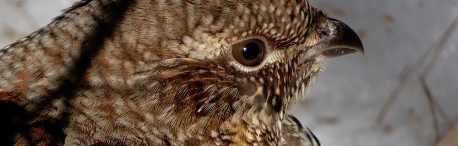
From Bear to Beer Possibilities
Christmas in our house requires a bit of creativity and so it was that a light bulb went off and a theme was born.

I found a little brown cardboard box, decorated it with some hiking stickers and then did a bit of research on local trails and pubs. This was for my guy, you see, for on his days off, he’s always asking me where we should hike. I decided to make it easy for him to suggest a trail at least once a month, and the hike would be followed by sipping a brew at a local pub. There was one caveat: the hike had to include the search for bear paw trees. We both love a challenge. Some of the places I chose are familiar to us, and though we know the trees are there, will we find them again? That remains to be seen. Others are totally new on our list and I had no idea if they’d offer one of our favorite sights.

In keeping with the theme, I also gave him a UMaine sweatshirt; UMaine being his alma mater. Of course, back in his day, it was referred to as UMO for the University of Maine at Orono.

And finally, a growler from a local brew pub so he can walk down the street and refill it occasionally.

It was Western Foothill Land Trust‘s Packard Trail that he chose for this first adventure.

The property itself is the Virgil Parris Forest, named for this man who was born in Buckfield in 1807. Mr. Parris attended local schools, Colby College, and Union College in New York, where he studied law. In 1830, he was admitted to the bar and returned to his hometown to open a practice. His career followed a political path both at the state and national levels.

The main trail that loops around the 1,250-acre property was named for the Packard Family. According to the interpretive panel at the trailhead, “the farmstead’s foundations and family cemetery are on site. Daniel Packard was given this land in Buckfield as compensation for his service in the Revolution. Daniel was born in Bridgewater, Massachusetts in 1749 and married Elizabeth Connelly of Cork, Ireland during the war. Daniel died in Woodstock, Maine in 1836, and is buried there. It is said that Daniel and Elizabeth were the prototypes for James Fennimore Cooper’s Sergeant Hollister and Betty Flannigan in Cooper’s novel The Spy.”

The sky was brilliant blue as we began our journey, each step of the way scanning the trees. Had it been a couple of months later, we might have mistaken the large burl in a paper birch for a bear cub.

Though bears climb other trees, it’s on beech bark that their claw marks show up best.
When one focuses one sees . . . many a thing that might have been passed by, such as this beech, which began we know not as one or two, and if one, why did it become two we wondered? And then, like a work of magic, it was once again unified.

Another beech offered a snow chute that seemed like the perfect squirrel slide.

And yet another was decorated with the chiseled tooth marks of a natural logger–a beaver.

There were some decorated with cankers from beech scale disease that could have passed for ornamental faces.

And others that hosted squirrels who had built dreys appearing haphazard in construction from our stance about thirty feet below, but were really complex and apparently well insulated.

Fungi, such as this tinder conk, also fruited upon some trees. But . . . where were the bear trees? My guy asked how I’d chosen this particular path, and to be truthful, I couldn’t remember. I just thought it was a new one to us and might have some paw marks to boot.

Down an esker ridge we continued as we approached South Pond.

The wind was cold on the pond and snowmobiles zoomed past, oblivious to our presence, which was just fine with us.

And then we heard voices and framed between beech branches, we saw a dog sled team across the way.

And then, just as we turned from the Packard Trail onto the Cascade Trail, we spied some familiar marks. Or were they? We so wanted a bear paw tree that we convinced ourselves we’d found one.

It certainly did look the part. And so we felt successful.

Onward we journeyed, enjoying the cascades in their frozen form and promising ourselves a return trip in a different season.

As is his style, my guy moved quickly and I accused him of not searching, but he was.

And bingo! Another bear tree.
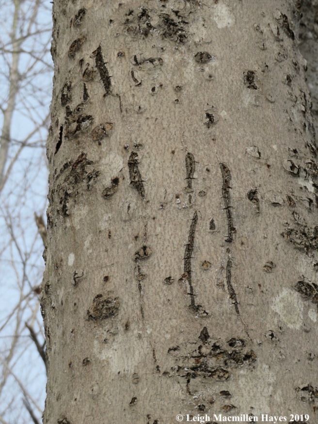
The cankers were abundant and made it difficult, but our bear paw eyes discerned the patterns.

And once we noticed, it seemed as if they began to pop out at us from every tall beech. Not really so. All in all we counted five. Well, five if you include the first tree, which we continued to question. And there were probably many more that we missed.

At last we’d completed our journey and relished our success. As I drove back down Sodom Road in Buckfield, I knew there were a few final trees that needed to be examined–telephone pole trees. Most were in great shape, but one close to the preserve had been visited by a large furry mammal that scratched it and nipped it and probably left a scent on it.

As planned, we knew exactly where we’d stop following our hike and so we made our way to the Buck-It Grill and Pub, another place we’d never visited before.

Lisa, the bartender, took our burger order and then we sipped Allagash White while we watched the Weather Channel on the TV above. Sitting next to us was Joyce, and she said that the impending storm was named for her partner’s niece, Harper. When did they start naming winter storms? Never mind. The important thing was that the fresh hand-packed burgers and fries were delish. The beer wasn’t bad either.

We went not knowing but came away with smiles after a successful hike–and already we’re looking forward to next month’s “From Bear to Beer Possibilities.”
Bear to Beer: Middle and Peaked Mountains
My guy opened his Christmas Bear to Beer box and considered the possibilities. The winner was . . .

Middle to Peaked Mountains in North Conway, New Hampshire.
The day had dawned warm after the recent deep freeze and so we had to consider how to dress and what to use for footwear.

Given that our route would take us uphill as we ascended via the Middle Mountain Trail to Middle Mountain, retrace our steps to the connector before summiting Peaked Mountain and then follow the Peaked Mountain Trail down, we knew we needed to dress in layers, but not quite so many and not quite so heavy.

We also weren’t sure of our footwear until we arrived at the parking area and saw the well-packed trail. Our choice–micro-spikes over snowshoes. We only hoped that when we reached the intersection of the Middle Mountain Trail and the Connector Trail, we wouldn’t regret our decision. But time would tell.
In the meantime, after we climbed over the snowbanks to get to the trailhead, we had to conquer the gate. We’ve climbed Peaked in the past, as well as walked the Pudding Pond Trail, both part of the Green Hills Preserve, so we knew that typically one walks around the gate. Today, we merely stepped over it–which tells you something about the snow depth.

At .2 miles, the trail comes to a T. The right hand route leads to Pudding Pond, while the left requires a brook crossing before continuing on to the mountain trails.

A bit further along, we came to one set of several that denote the trail system. In terms of following it via the signs, trail blazes, and well worn path, it was easy. Given the soft snow conditions and contour, we’d rank it a moderate hike.

It was one that got the hearts pumping, which is always a good thing. And when one of us needed a rest, we pretended that we just wanted to admire the sound and sight of the gurgling brook.

We passed through a few natural communities, including hemlock groves, and mixed forest. But our focus was really on any beech trees and by the leaves that littered the path, we knew there were plenty.

We scanned the bark every time we spied a beech, and saw not a nail scrape anywhere. But . . . sad to say we did notice tarry spots which oozed out of the cracks in the bark caused by cankers a tree develops as a defensive attempt to ward off beech scale insects and the nectria pathogens that follow their entry points.

The community changed again as we approached the summit of Middle Mountain, where red pines dominated the scenery. And in the warm sun, the snow became softer.

Two miles and some sweat equity later, we’d shed some clothes and reached the top.

From there, my guy went in search of lunch rock and I eventually followed.

It was actually more of lunch ledge and we set up camp, using the jackets we weren’t wearing as our seating area.

The view beyond our feet included Conway Lake in the distance. Lunch consisted of chicken salad sandwiches made with our own cranberry orange relish offering a taste of day in the fen picking berries, a Lindt peppermint dark chocolate ball, and an orange, topped off with frequent sips of water.

While we sat there, I did what I do. There were no beech trees to look at and so I focused in on the bonsai red pine in front of us. It’s form, unlike its relatives who stood tall behind us, was the result of growing on the edge of the ledge where it took the brunt of the weather.

I took the liberty of turning a photo of a lower branch 90 degrees because I could see the face of the tree spirit reaching out as it formed a heart. It is February after all.

But enough of that. We were on a mission to find a bear paw tree. When I chose this trail, I had no idea if we’d see one. Yes, we’d climbed Peaked in the past, but never had we noticed any trees with such marks left behind.
So, down we slid, I mean climbed, off Middle Mountain until we reached the connector and could see Peaked’s summit in the background.

We weren’t too far along when our constant scanning paid off! Bingo. A bear paw tree. Some people bag peaks. We bag bear paw trees.

Our mission accomplished, though we continued to look, we journeyed on to Peaked Mountain.

From there, we had more of a view of North Conway below, the Moats forming the immediate backdrop, and Mount Chocorua behind.

In front of us, we looked across to Middle Mountain from whence we’d just come.

And behind, Cranmore Mountain Ski Area and Kearsarge North in the background.

With my telephoto lens I could pull in the fire tower atop Kearsarge. It’s among our favorite hiking destinations.

We didn’t stay atop Peaked as long as we had on Middle because the wind was picking up. On our journey down, the mountain views included Washington.
We continued to look for bear trees but found no others. That being said, there were plenty of beech trees on the Peaked Mountain Trail, but the sun was in our eyes for much of the journey, and we had to pay attention to where we placed our feet because traveling was a bit slippery given the soft snow. Maybe there were others after all, and we just didn’t notice.

We completed the 5.5 mile hike about four hours after beginning, ran a few errands, and finally found our way to the finish of today’s bear to beer possibility at the Sea Dog Brewing Company. Black bears like to sip too!
Bear to Beer: Peabody-Fitch to Bear Trap
Our bear to beer tour was supposed to last a year, but here it is February 18, and we’ve already completed three of the treks. I think my guy really likes this Christmas present.
If you aren’t aware, for Christmas I gave him a small box I’d decorated with hiking stickers. Inside were thirteen pieces of paper (actually bobcat prints post-its) upon which I’d written the name of a trail where I thought we might find what we call bear trees for they are trees with bear claw marks, plus a place to grab a pint after the hike.

Because it was snowing today, we decided to stay closer to home and visit a property we hope Loon Echo Land Trust will soon own. It surrounds the Bridgton Historical Society’s Narramissic Farm and is one of our favorite places to wander in any season.

Rather than cross through the field as we usually do, I suggested that we follow the former road (current snowmobile trail) behind the barn. At the first stone wall, we passed from the Narramissic property on to what we hope will become the 252-acre Peabody-Fitch Woods that Loon Echo will own once they reach enough dollars to make the purchase.
Another part of my guy’s Christmas present was a donation toward said purchase, which an anonymous foundation will match. It seemed like a win-win deal when I sat down with Thom Perkins, former executive director of LELT to discuss the property proposal. And then last month I co-led a walk along part of the route we followed today and had the joy of learning more about it from Jon Evans, Loon Echo’s Stewardship Manager, and Matt Markot, LELT’s new executive director.

Not far down the snowmobile trail, we turned left at a stone wall, the same as we had during the LELT walk in late January. I was sure this was a route new to my guy, but it turns out it used the be the snowmobile trail and so he knew it. Right away, as we hobbled over and pulled up some downed trees, we began to see a variety of mammal prints muffled by the morning’s snow. Both prey and predator make their homes there and the property’s importance as part of the animal corridor was obvious.

Eventually, the trail swung around and rejoined the snowmobile trail. We followed it for a bit, then turned off at the blue arrow for that was our chosen way for today. It appeared that someone had an eye on my snowshoes.

We’d no sooner started along the trail when I heard the rat-a-tat drumming of a male hairy woodpecker. Of course, I needed to pause and watch him for a few minutes. And wonder about the purpose of his drumming. Was he establishing territory? Trying to get a date?

My guy was patient with me, but our mission was about more than the birds, and so we journeyed on. Mind you, we kept looking at the trees along the way, but suspected we’d find bear evidence on our return trip when we planned to go off trail. In the moment, we were eager to get to the quarry and find lunch rock.

It was buried, but my guy in his chivalrous manner, wiped the snow off and we each ate a slice of cold, homemade pizza and drank some water.

Behind lunch rock, plug and feather holes served as reminders of an earlier time–much earlier than either of us remembered. The quarry was the source of the stone foundations for Narramissic, the Peabody-Fitch Farm, which dates back to 1797.

With lunch under our belts, onward and upward we hiked until we reached a certain stone pile.

Mind you, it’s located a tad from the proposed Peabody-Fitch Woods, but still, we love to visit bear trap and imagine the past.
I’ve quoted this before, but it’s worth sharing again.
How did the bear trap come to be? According to an August 17, 1963 article in the Bridgton News, “Enoch Perley, early settler of South Bridgton, built his first house in 1777 and brought his bride to their new home in 1778. [I believe this was at Five Fields Farm.]
As Enoch acquired livestock, he was much troubled by depredations from bears. He built a bear trap on the hill back of his first home . . .
Tradition says that four bears were caught in this trap–not enough! So Mr. Perley later had an iron bear trap made which took care of eight bears. Without a doubt, many were disposed of by him personally. A story is told that in an unarmed encounter with a bear and two cubs beside a wood road at dusk, Mr. Perley allegedly strangled the mother bear with his garters . . .”
The article continues, “The bear trap is built of stone. A large stone door is suspended and as the bear takes the bait, he trips the lever and is caught in the stone enclosure.”
In a December 1954 issue of the Bridgton News, a brief article states: “The old stone bear trap on the mountain in South Bridgton known as ‘Fitch’s Hill,’ unused for more than one hundred years, has been reactivated by Dr. Fred G. Noble and Gerald Palmer and put in readiness to capture a bear.” As the story goes, they never did succeed.

In honor of the Perleys, Peabodys, Fitches, and the bears, we’d brought along a growler, a Valentine’s Day present from my guy to me.

We each enjoyed a few sips and then peered inside the trap to see if anyone had taken up residence. Perhaps we should have done that first! Thankfully, no one was home.

Eventually, we headed back to the trail, but didn’t spend long on it.

Instead, we began looking for bear trees. To test your visual acuity, can you spot my guy?

I couldn’t always see him for we split up for about an hour and zigzagged our way from one beech tree to another. I found one that gave itself a hug.

There were those with false lines. Well, they weren’t really false, but they weren’t caused by a bear either. Instead, surrounding saplings blowing in the wind had scratched them.

Then there was the tree that seemed to have stitch marks on the outside of its wound. Unfortunately, the stitches didn’t help.

One of my favorites was the beech that made me think it was a deer bending over as if to take a bow.

That made perfect sense in these woods where the deer did dine.

And at least one rubbed its antlers.

Suddenly, from a distance I heard my guy call to me. He thought he’d found what we sought. A bear tree. The growth at the top certainly leant itself to that assumption.

I’m not one hundred percent sure that he was right, but there were some marks that looked consistent with bear activity–a bear with a very big hand.

Closer to the trail, we did find another tree with bear sign–left behind by Teddy Bear and K.F., whoever that might be.

About three hours after crossing through the stone wall behind the barn to enter the future Peabody-Fitch Woods, we did the same at the far end of the farm field.

And in the end, even if our bear tree wasn’t exactly that, we’d still had a bear sighting–in the form of the trap. Today’s brew was Double C.R.E.A.M. Ale from Bear Bones Beer Brewery. Bear to beer possibilities: Peabody-Fitch to Bear Trap.
Bear to Beer: St. Patrick’s Day
We drove to O’Lovell in western Maine late this morning with the plan to search for bear trees in an area where I’ve seen them in the past.

All along the main road to the Greater Lovell Land Trust property, Irish flags decorated random telephone poles and even a tree. The latter was our favorite for the person who hoisted it had to climb up the steep snowbank in order to show off the colors of the Emerald Isle.

Braving a thousand bumps, or so it felt as we negotiated potholes, frost heaves, and culvert depressions, we at last arrived at the end of a dirt (read: muddy) road and prepared for a hike up the oxymoron called Flat Hill.

While yesterday’s trek meant slogging through the wet snow, today’s brisker temperature allowed us to stay on of the wintery surface, though we were thankful for our snowshoes.

Upward we climbed until we reached the coppiced red oaks and knew to turn right, walk off trail and begin our search among the beeches in the forest. You see, I knew there were trees to be found for I’ve seen them before, and I knew the turning point tree, but . . . the last time I looked, I couldn’t locate the trees with the bear claw marks. That, however, is a challenge my guy heartily accepts and so we split up and each set off to check all the trees in the forest. Well . . . almost all.

As is to be expected, my guy covered much more territory at a faster rate than I did and I wasn’t surprised to hear the distant call, “I got one!”

Indeed, he did. And a beauty was it. Can’t you just see the bear shimmying its way up and down the tree–several times over.

In my brain, a bear hug was the real deal from one of the original tree huggers. And I gave thanks for being accused of doing the same.

All the way to the top we could envision the quest for those tiny beech nuts that offered nutrition. Hmmm . . . isn’t it curious to note that the core of nutrition is “nut”? Or is it curious?

From the big tree, we moved up the mountain until we reached its sort of flat top where the view to the west is always a treat. And then we began to look about, for usually there is porcupine sign in the immediate vicinity to enjoy–that is . . . until I offered a porcupine prowl there two weeks ago and all we found were fisher tracks.

Today, however, was different and we found some fresh evidence that the porcupine is still in the area. We knew it by the teeth impressions left behind.

Further evidence was seen in some diagonally clipped twigs, scat, and even a strand of hair! Yes, porcupines have hairy bodies–including their quills. But on their bellies and faces they have a silkier variety–do you see it?

While I looked about the summit for more evidence, my guy stalked about below. Can you see him in the middle of the photo?

Eventually I wandered down to join him, pausing halfway to note some porky tracks leading upward . . . and downward, of course.

Below the ledges we hunted for his den, but found only tracks moving along the edges.

Though we never found the critter that we assume could easily look like a miniature bear if one were to remove all its quills, we enjoyed exploring the territory that is part of his home.

The delightful part of paying attention is the noticing. There were the organ pipes attached to the ledges, their music enhanced by drips onto rock tripe, ferns and mosses.

And an icicle of amber that stood at least two feet long.

Eventually we made our way back up and then down, again bushwhacking to look for more bear trees. We found a couple, but it was the works of others that also garnered our attention, such as this one that decided to split, but then came back together as if it was making up for time spent apart.

We found another tree with a burl that could easily have been mistaken for bear cubs spending time in a nurse tree. Typically, however, mama bear would choose a white pine for it would provide cover for her young ones as she went off to search for food for her brood.

Embedded in the snow was a squirrel drey and we mentally noted its location so we can go back another day after its no longer frozen in place and try to dissect it in hopes of better understanding such a structure.

And we spied a stonefly exoskeleton–an offering of total delight for despite its minute size, its discovery was right up there with the bear hug.

At last we left O’Lovell, with its Irish flags flying in the breeze, and found our way to O’Harrison, where we joined our friends, the O’Wisers for a beer and dinner.

The evening was topped off with Irish music performed by our favorite local acoustic folk band, Bold Riley.
From bear to beer, everyone was Irish today as we celebrated St. Patrick’s Day. Well, almost everyone–I did wear some orange and donned my Macmillen plaid flannel shirt. O’Macmillen! O’Hayes! O’Bear!

You must be logged in to post a comment.