Since November, newly minted Maine Master Naturalist Dawn Wood and I have co-led a program we call Wednesday Wanders for Loon Echo Land Trust in Bridgton, Maine. This past week, channel 8 WMTW reporter Jacob Murphy and his videographer Ethan joined us for a tramp into a vernal pool at LELT’s Tiger Hill Community Forest in Sebago.
It was a dark and dreary night. Repeat. It was a dark and dreary night. Repeat. It was a dark and dreary night.
While most folks would choose to stay inside curled up by the fire while drinking a hot toddy, a number of intrepid community scientists ranging in age from 3 to 70+, donned rain gear (even waders) and reflective vests, cleansed hands of soap and moisturizer, grabbed flashlights and headlamps, and met at 7:30pm in the pre-determined locations.
Their mission each night was the same: Help us help frogs and salamanders cross the road to avoid getting squished by vehicles.
The names and ages of participants changed each night, but the leadership remained the same. As Maine Master Naturalists, Dawn Wood (who took the lead on organizing these events and recording data–a daunting task in the rain and dark and with people spread out and shouting numbers and species at her), Hadley Couraud, and I led the way, all three of us providing information about the different critters and their behavior as the evening progressed. All of this was under the umbrella (pun intended–though no one actually had an umbrella) of Loon Echo Land Trust in Bridgton, Maine. Thank you to Maggie Lynn for creating the sign-up forms, advertising the events, and keeping us posted.
The technique was easy. Once we reached the location of the vernal pool, to which amphibians return each year from their upland habitat, we started scanning the road with our lights. It’s amazing how the mica, small rocks, sticks, and lichens can fool us.
It’s equally amazing how much tiny Spring Peepers resemble small rocks. And how stone cold they are when we lift them up. And how they’d rather stay in our hands than return to the cold earth.
We always noted the direction in which they were headed and that’s the side of the road we took them to, even if it didn’t make sense to us. They knew what they were up to and we were there only to try to keep them alive so they could canoodle for a few nights before heading out of the pools and back to the forest.
Meet a Spring Peeper up close and personal. Note those little toes, which are actually suction cups of a sort, the better to climb vegetation, especially at the edge of or in a wetland, and then to sing their high-pitched songs that announce the males intention of finding a date. Because of the toe pads, peepers were originally thought to be closely related to Tree Frogs but they have since been reassigned as chorus frogs in the genus Pseudacris, which comes from the Greek pseudes (false) and akris (locust) (think of our Dog Day Cicadas and their raspy love songs in the summer).
The species name, crucifer comes from the Latin cruces, meaning “cross,” so named for the dark X or cross on the frog’s back.
A really cool thing happened that first night. A teenager who lived in the neighborhood where we were scanning the road came out to ask what we were doing. And then he joined us, eager to learn as his family had recently moved here from out of state.
After a Spotted Salamander was saved, he ran home to get his camera and stayed until we finally departed. We had hoped he’d join us the next night at a different location, but wonder if he stayed home to help those on his road instead. Whether or not he did that, we loved his enthusiasm and desire to learn.
It soon became clear on the first night that we’d parked in the wrong spot, however right it may have seemed because we could get our vehicles off the road. As people started to leave, we all did a check underneath from all angles to make sure tires would not run over any critters by accident.
And sure enough . . . out crawled a Spotted Salamander. Of course, photo calls came first, and then help was offered to get to the other side.
Even teeny, tiny Spring Peepers had to be saved. And we all commented that we didn’t want to know if we did happen to drive over something. Added to that, we noted most of the vehicles only made it a few feet down the road, before the driver stopped and another amphibian was saved. That and the driving was rather erratic since everyone had gained a new understanding of how much action there is on a rainy night.
The second night found us in a different location that we actually walked about three quarters of a mile to reach, thus lowering our chances of hitting the critters right near the pool which is located directly beside the road, with a vast wetland on the other side of the street.
Wood Frogs, with their dark masks, typically headed toward the pool, where they’ll spend the next two weeks or so, singing for a mate, embracing her in a technique called amplexus, fertilizing her eggs, and trying again and again, until it’s time to hop out and head into the forest for the next 50 weeks.
Because it was dark, the Wood Frogs didn’t seem to mind our presence too much. Some still sang, or rather “wruck, wrucked” their love songs, and others floated in anticipation or chased each other in hopes of finding a female. We even noted a few egg masses clinging to branches, telling us this pool had been busy for a few days already.
Part of the fun in hosting such an event is sharing it with other people who might not typically head out the door after dark. And then seeing smiles on faces as they encountered the critters for the first time.
A cool find on this night was an Eastern Newt crawling across the road. Perhaps because the pool dries up each summer, this one had overwintered either in the wetland or even the upland before returning on this particular night. It felt like an unusual find on the road, though from what I’ve read, it’s not rare. I have seen many Red Efts, the juveniles of this species, their bodies squished by vehicle tires, on this very road in the fall.
Yet again, it was the Spring Peepers who garnered much of our attention.
And some Spotted Salamanders, though not as many as on the first night.
That said, we were thrilled with each find. And found an easy way to help them was to place the laminated ID card created by Maine Master Naturalist Michael Boardman under their bodies. Now don’t you think this guy is crawling onto the card in search of his ID?
As we prepared to walk back to our vehicles that night, Officer Hammond of the Bridgton Police Department happened along. No, he wasn’t going to arrest us for J-walking, though that’s essentially what we did. He was just stopping by because we’d ask Maggie to let the department know of our whereabouts in case anyone wondered what we were doing, but didn’t slow down to ask us. Traffic was high each of the nights. I’ve been doing this for about 22 years, and this year I felt like we had the most traffic. Most drivers were considerate when they saw the cones (courtesy of Hayes Ace Hardware) and vehicle flashers, plus our headlamps and flashlights. And we were all good at yelling “CAR” each time we saw approaching lights, but there were a few who were annoyed and one even had to lean on the horn after passing through the section of road we walked upon.
Night three was the warmest, with temps in the 50˚s and little to no rain. In fact, by the time we were heading home, the moon and stars were visible.
But still, the critters crossed and once again we showed new participants of all ages how to ID them and then help them cross the road.
On this final night, we had several teenagers along for the journey. Two of them had actually driven past us on the first night, slowed down, rolled down the window, and asked if we were okay. When we showed them a photo of a Spotted Salamander, they went home and signed up for a chance to help. Their enthusiasm was incredible.
We peered into the pool again and were amazed at the number of swelled Wood Frog egg masses in their communal cluster–as is the Wood Frog fashion. perhaps to take advantage of being warmer when crowded together, and thus evolve quicker. It’s the swelling that told us they’d been laid a few days before as initially their egg masses are maybe the size of a golf ball, but swell as they absorb water over the days to come.
The action was constant and I encourage you to see how many frogs you can find in this photo. It’s almost like the Hidden Picture of Highlights magazine, or Where’s Waldo?
And twice we spotted Spotted Salamanders swimming in the pool, though I really wanted to see a “congress” of salamanders conducting their mating dance. One of these nights.
As we walked out on the third night, about ten feet from each other we spotted two sets of Wood Frogs in amplexus! They couldn’t even wait to find a room, or pool, for that matter!
We quickly, if awkwardly, helped them off the road because we heard that familiar “CAR!”
One night, two nights, three nights . . . turned into one incredible and extended BIG NIGHT migration.
Our results:
April 10, 2024
21 Spotted Salamanders
40 Spring Peepers

April 11, 2024
7 Spotted Salamanders
102 Spring Peepers
75 Wood Frogs
3 Red-backed Salamanders
1 Eastern Newt

April 12, 2024
13 Spotted Salamanders
268 Spring Peepers
62 Wood Frogs
4 Red-backed Salamanders
2 Green Frogs
1 Eastern Newt

For a grand total of 599 critters helped to the other side of the road. We saw a number of squished ones and had to constantly remind ourselves that they will become food for others.

Thank you to the 39 people who joined us during these three nights--you were incredible and we loved hearing stories of how you want to share this with other members of your family and you are already planning to join us next year.
To go out on a rainy night and help amphibians cross the road is special–for the critters and for us. Thank you to Hadley, Dawn, and Maggie–for being the cool swamp critters that you are! And for letting me be part of the club.
Today’s wander begins at the end because it can in my book of life. And by the end, I think you’ll understand why I made that choice. But don’t scroll ahead cuze then you’ll ruin the surprise.
Our deer friends are feeding on bird seed and corn right now about ten feet from the back door. Meanwhile, the fairies are flittering about behind this doe. Do you see their twinkling wands at work?
Actually, all the lights are kitchen reflections on the door window.
This, of course, has nothing to do with the rest of the day, but I do love our deer friends and like to honor them when I can.
Now on to the nitty gritty of the rest of the story. My friend Dawn and I are Maine Master Naturalists as you may know. And because of that, we must volunteer time to teach others about the natural world. An unpaid job that is hardly a hardship because it’s so much fun.
Right now, we are in the midst of offering a program every other week for Loon Echo Land Trust in Bridgton. And the winter focus is tracking. Not easy to do without snow or mud. Wait a second. The animals are always on the move, and without the snow, we must look for signs. And so we did.
The first, a special offering left on top of a rock that Dawn actually noticed this past weekend when her son and daughter-in-law were visiting, and which she complety embarrassed him by taking photographs of it.
Out came my scat shovel today and everyone took a look. By its form, size, and location, we determined Red Fox.
Our real mission today, however, was to explore the territory of a Red Squirrel. No, this is not my friend Red, but another who has established a territory in a different space that’s also been blessed with an abundant amount of pine cones this year.
We wanted the partipants to take a close look at the scales where the seeds the squirrel sought had been stored. They got right into it.
After locating caches and middens created by said squirrel, we taught the ladies how to use a loupe, aka hand lens, by holding it close to their noses and bringing the object closer until they could focus on it.
To say it opened up a whole new world is possibly an understatement.
Discovering the tiny seeds the squirrel consumes would have been enough, but there was more. In one section of this squirrel’s habitat we found numerous mushrooms upon branches, placed there by the rodent to dry. Talk about being in a food pantry.
And then . . . and then . . . we spotted hoar frost between a couple of stacked logs . . . and surmised that our little friend was living in the space below. How cool is that? Wicked, in these parts of the woods.
What we learned is that this particular squirrel’s territory is located between two downed trees and a wetland, about the size of half a football field.
At the edge of the wetland, it was time to turn our attention from the squirrel to another rodent.
Yes, a Beaver. Once our eyes cued in, just like spotting the squirrel’s mushrooms, beaverworks made themselves known.
And so we encouraged partipants to channel their inner Beaver and try to chop down carrot trees.
Like any Beaver, they were eager to shout, “TIMBER.”
And rejoiced when their tree stumps matched the Beaver’s sculptures.
Finally, we took them along a path that led to more Beaver works, where we noted how its the cambium layer that this rodent seeks for its nutritional value. The rest is left behind, rather like a squirrel’s midden.
And so the inner Beaver channeling continued, this time with pretzel sticks and they were challenged to only remove the outer layer.
The competition was stiff, and a couple of Beavers broke their sticks so we’re not sure they’ll survive the winter.
But at least one was super successful.
While only one Beaver fells a tree, the family may help to break that downed tree into smaller pieces and there are at least three sections like this indicating that they’ve worked on it–maybe one at each spot. We don’t know for sure, but that’s the picture we like to imagine.
Below where we stood, we spotted the dam and talked about construction.
And then located the lodge. Another cool thing–more hoar frost at the top where a vent hole exists and is not covered with the mud that insulates the rest of the structure.
By evidence of the frost, we suspected the family was gathered within, probably consisting of mom and dad, at least two two-year-olds who will move on in the spring, and maybe a few youngsters.
As we walked beside a trail on our way to check out another lodge we determined wasn’t active, one among us discovered a kill site. So here’s the thing. When we first met in the parking lot, that same participant pointed to a Bald Eagle that flew just above the trees.
Could the eagle be the predator of what had been a duck? We suspected so.
The blood was fresh.
Nearby a Mallard had been quaking and we thought it was laughing at us and our enthusiasm and inquisitiveness. But perhaps it was lamenting the loss of a mate. Or at least trying to locate the mate that had become a meal–providing energy for another to carry on.
Yes, it’s sad. But this is nature. This is how it works.
After two delightful hours of discovery and learning, we said goodbye to everyone, dropped in at Loon Echo Land Trust’s office, and then went on a reconnaissance mission at another local spot, trying to determine if we should use it for a class we’ll teach for Lake Region Lifelong Learning, another volunteer venture.
And it was there, that just after we’d talked about being in hare territory and knowing that the lack of snow meant that a hare would stand out amongst the leaves, that . . . Dawn spotted a Snowshoe Hare.
We were so excited about how the morning had unfolded and spying the hare was a grand reward.
Can you track mammals without any snow. YES!
Wednesday Wanders, oh my! So much to learn. So much to share.
My Guy and I took in an old fav from a different perspective today. That’s because I always thought that the Micah Trail at Loon Echo Land Trust’s Bald Pate Mountain Preserve was for Camp Micah only. This morning I learned that anyone can begin the ascent via this sweet trail and so we made it our mission to do so this afternoon.
There is room for about four vehicles to park at the trailhead on the left-hand side of Moose Pond Cove Road off Route 107 in South Bridgton, Maine. Maps are available at the kiosk located a few steps in from the parking area.
Afew more steps and we met new bog bridging, always a welcome sight and so we crossed and then continued on up the trail, pausing frequently to search for bear claw trees among the American Beeches.
No such luck in the bear claw department, but we were serenaded by a flock of Chickadees singing their rather wispy fall songs, if they are songs indeed.
And a Hairy Woodpecker or two did what woodpeckers do . . . it pecked. This is a male as you can see by the hint of red at the back of its head. And he’s all puffed up, in reference to the brisk temperature of the day. Trapping air between his feathers helps him to warm up. Wearing several layers helps us do the same.
Once we reached the South Face Loop Trail, it was a quick ascent to the summit. Just before the summit, we paused to honor the bonsai tree–which is really a Pitch Pine. The summit of the pate is home to a Pitch Pine Forest. Though these trees can stand straight and tall, on mountain tops they take on a contorted structure.
The “pitch” in its name refers to its high resin content, thus making it rot resistant.
The needles are bundled in packets of three–making it easy to remember its name: Pitch–three strikes you’re out!
Another easy way to identify Pitch Pine is to look for needles growing right out of the bark–both on the trunk and branches.
Pitch Pine cones take two years to mature and upon the tip of each scale is a pointed and curved prickle.
They open gradually but depend upon fire for their seeds cannot be released until they are heated to an extremely high temperature.
That being said, this is the only native pine that will re-sprout when damaged.
I was told this morning that there had been some view openings and we were thrilled to discover a couple of them, includng this one overlook Peabody Pond with Sebago Lake in the distance.
And no visit to the summit is complete without paying homage to our friends Faith and Ben by taking a photo of their beloved Hancock Pond.
You may note the difference in the sky view from one pond to the next–snow showers are in the forecast for tonight so as we looked to the west, we could see the front moving in. No accumulation is expected, but any day now it will be most welcomed by us.
Though most of our foliage has dropped to the ground, another view at the summit included the scarlet colored blueberry leaves turning any day into a cheery one.
A quick loop we made next around the Bob Chase Trail, noting that we could almost see Mount Washington located in the saddle of our other beloved: Pleasant Mountain. On a clear day, this view is spectacular.
At last it was time for us to return to the South Face Trail and continue to follow the loop down. This section of trail we don’t often use so we did have to backtrack once and locate the orange blazes again.
You might think that upon our descent it would be the ice needles that gave us a difficult time. The six-sided slender ice constructions form in moist soil and can take on a variety of presentations from straight to arching curves. And yet, they grow perpendicular to the ground’s surface.
But, they were no bother and only crunched under our feet if we stepped on such in the trail.
The leaves, however, offered a different story. We had to make sure we weren’t fooled by the fact that many American Beech leaves still have some greens and bronze hues.
And others, though dried up, will wither on the trees until spring as they are marcescent (mar-CESS-ent). Some trees, such as the beech, especially those that are younger, choose to hang on to their leaves until spring.
Most deciduous trees drop their leaves in autumn, when cells between the twig and the leaf’s petiole create an abscission layer, thus causing the leaf to fall off. Not so in the case of marcescence, and I know that many will rattle and initially startle me all winter long. But, they also provide another hue in the winter landscape.
Northern Red Oaks also do the same, though in my observations, many are loosing their leaves with November winds, but some will remain throughout the winter.
Today, three seemed to play Tic-Tac-Toe on the trail before me.
So, young beech may retain their leaves, but look toward the sky and you’ll notice bare branches and look at your feet and you’ll see where they have all landed. A word of warning if you are hiking in New England right now–these leaves make for a very slippery slope, especially upon your descent. Hike with caution. Even My Guy has learned to do this.
As our hike came to a close, I noticed two trees close to the trailhead that I’d missed on the way in. An Eastern White Pine and a Paper Birch. Do you see what I see?
They had found a way to grow in the same space and actually fused together. Wind must have caused frequent branch movement. It probably took many years for the surfaces to gradually abrade, with the cambium of the trees touching and forming an adhesion, necessary for a graft union, and the trees fused.
It always strikes me when trees do this, especially those of different species. My Guy and I had been on a slippery slope on this Mondate, but the world seems to be on an even slipperier slope these days.
Maybe we all need to be like the trees and figure out a way to live together without so much conflict.
The morning began as Tuesdays do in my current world, with a visit to a Greater Lovell Land Trust property accompanied by a group of curious naturalists we know as docents who love to do deep dives on every little thing that we encounter and in the midst we share a brain. A collective brain is the only kind to have, in my opinion, because we each bring different knowledge or questions to the plate.
And so it was when we first encountered what could have been a hair ball of sorts and then discovered this hair-filled scat about a yard beyond. And near it another “hair ball.” Based on size and structure we determined the scat belonged to a bobcat, and thought that the hair balls made sense as maybe the cat had to cough up some of the hair of the mammal consumed. What did it eat? Well, we know both snowshoe hare and deer frequent this place and so it could have been either.
A little further down the trail we reached a beaver lodge that some of us had seen under construction in August 2022, and gathered game camera photos over the course of time, and spotted all kinds of sign of activity each time we visited, until that is, May. When it rained. And rained. And rained. In a torrential manner. And the dam the beavers had built was breached. And they disappeared. And we know not their fate.
But the beauty of a beaver pond is that once breached, change happens and other critters take advantage of the space and there’s so much possibility and we can’t wait to watch how this space, one in which we could walk prior to August 2022, will evolve and other flora and fauna may move in until another beaver family takes up residence and changes it again.
About an hour or so after departing, a call came. Well, really, it was a typed message. But as my morning peeps know, shout, “Kill site,” and no matter what I might be focused upon, I’ll come running.
The message included a few photos of a mammal skeleton and a thought that it might be a beaver that had become the meal because it was located close to another beaver pond. Beaver ponds are plentiful in the landscape of western Maine.
After a few messages back and forth, the writer and I agreed to meet and walk to this site. Take a look. The meal this skeleton became had been consumed months ago, I suspect in the winter, given how much was missing, including the head. And even after any hide and meat had been eaten, the bones continue to provide calcium for rodents seeking such.
Since my guide suspected beaver, I knew I had to slow my brain down and assess the evidence. My, what long toe nails. And though some were broken, it seemed obvious to me that they were all oriented to the front of the foot. Plus, there was no evidence of webbing.
A bigger clue was observed with a closer look. Barbed quills sticking into the spine. I pulled one out and we examined it.
And about a foot away, a pile of quills, with vegetation growing through them adding to the age of the kill site.
And hiding there also, as if stuck into the ground, a quilled tail.
Did you know that porcupines have a variety of hair? For winter insulation, they have dark, wooly underfur. In addition, there are long guard hairs, short, soft bristles on the tail’s underside, stout whiskers, and then there are those pesky quills.
They aren’t pesky to the porcupine; just us and our pets and any animal that might choose to or accidentally encounter a porcupine.
Overall, a porcupine sports about 30,000 quills, and within one square inch on its back, you might count up to one hundred, as demonstrated by my jar of toothpicks.
The quills are 1 – 4 inches in length and lined with a foam-like material composed of many tiny air cells, thus their round, hollow look. There are no quills on the porcupine’s face, belly, or inside its legs.
Look at that nose. Soft hair indeed. As is the stomach. A fisher, which is a member of the weasal family and not a cat, will attack the porcupine’s face repeatedly.
Fishers and bobcats also have been known to flip a porcupine onto its back and then go for the belly. That doesn’t mean that they don’t get quilled, for in moments of danger, the porcupine instinctively raises its quills and positions itself with its back facing the predator, showcasing its formidable defensive strategy. but the predator does get a meal.
This dinner had long ago been consumed as I said. But was it a fisher or a bobcat who scored this meal? We’ll never know, but I give great thanks to Dixie and Red and their best friend Lee, for being such great scouts and sharing the results of their hunt with me.
Found a kill site? Give me a shout and I’ll come running.
It’s been a while since I’ve shared a Mondate mostly because it’s either rained, or we had errands to run, or whatever we did was something we’ve already done a million times before and didn’t seem worth sharing. And so this weekend dawned as a three day weekend for the two of us and we decided to dig in and have fun.
We began our journey on Saturday with a long (think 9.5 mile out and back, with some backtracking in the mix) walk on old roads deep in the woods of western Maine. Our goal was to find the Hand on The Rock. Yes, you read that correctly. The Hand on The Rock.
And we did. I’d heard friends talk about this over the years, but until recently didn’t know of its actual location. Yes, that’s my guy’s hand. But do you see the engraved hand on the rock? It was perfect for my guy to place his hand on top, as he’s left-handed.
Below the left hand is the name LH JEWETT, that features a backward letter J. According to Arthur Wiknik, Jr.’s Hand on The Rock essay, “The rock carver has been identified to be Leander Hastings Jewett. Leander was born on April 4, 1851 in Sweden, Maine to Milton and Eliza (Whitcomb) Jewett, and for a time lived in the northeast corner of Sweden known as the Goshen neighborhood.”
Continues the writer: “As with most young men in the 1800s, Leander was a working member of his family and likely chiseled the rock between 1868 and 1873, presumably out of boredom while helping his father do some logging.”
I think what I love most about all of this is that Wiknik acknowledges my friends Jinnie Mae and Dick Lyman, (may they both RIP,) for their historical knowledge.
Since we were in the neighborhood, we also stopped in at the Goshen Cemetery. The stones were discovered years ago under the duff and uprighted in situ. The tombstones are unmarked and as far as I know, two theories exist–an epidemic struck the neighborhood and those who died needed to be buried as fast as possible, or these were the tombs of the residents from the town’s poorhouse.
And when we finally returned to the truck, we were blessed to discover a bag of fresh veggies left by two dear friends.
That was Saturday.
Sunday found us driving across Hemlock Covered Bridge in Fryeburg, Maine. The structure has spanned the Old Course of Saco River for 166 years.
Built of Paddleford truss construction with supporting laminated wooden arches, Hemlock Bridge is one of the few remaining covered bridges still in its original position. Peter Paddleford of Littleton, New Hampshire, created this design by replacing the counter braces of the Long-style truss bridge, creating an unusually strong and rigid structure. It was reinforced in 1988 and one can still drive across (“You’re stating the obvious, Mom,” our sons would say.).
Our goal was to paddle under the bridge and head to Kezar Pond on this beautiful afternoon.
My guy had never actually travelled this route before, so it was fun to share the tranquil paddle with him.
A juvenile Bald Eagle greeted us from high up in a White Pine. And we greeted it back. As one should.
Reaching the pond, we discovered a beautiful day to the east and storm clouds to the west. And so it was a quick look-about and then a wise decision to turn around and paddle back to the bridge.
But first, a small skimmer dragonfly known as a Blue Dasher, begged to be admired. And so I did.
As soon as we started our return journey it began to sprinkle, but despite the rain, we were rewarded with another look at the juvenile eagle as it flew down to a tree limb beside the river.
Did we get wet? A tad bit. It was a gentle rain, however, and since it wasn’t cold, we didn’t mind.
Was my guy faster than me? Yup. But he waited under the bridge until I caught up.
And then today’s decision was to climb The Roost trail in Evans Notch and hike along another trail in Shelburne, New Hampshire. The Roost is a fun loop that doesn’t have much of a view at the summit.
But we found things to look at that made up for it, like this Clintonia, aka Blue Bead Lily, growing out of a dead snag.
And this mystery plant for my naturalist friends to identify.
The trail down that we chose to follow was a wee bit longer than that ascending The Roost, but offers a much more gradual descent. And four water crossings.
And a view of Hobblebush leaves speaking of the future. Since I mentioned Jinnie Mae earlier in this post, she had to be smiling down upon me when she saw that I was taking this photo. She used to tease me about all the Hobblebush photos I took. But it always has something interesting to offer, no matter the season.
At the final stream crossing, we spied an old sluice way that speaks to the history of the area once known to support many logging camps. We were just below Hastings Campground and Hastings was formerly a booming village during the early 20th Century.
There are also bricks in the water, so I wondered if a grist mill or saw mill had been operated here.
As we walked back up Rte 113 to complete the loop and return to my truck, we took a detour across the bridge over Wild River. It’s part of the snowmobile route when the white flakes do fly.
Our next plan was to explore Shelburne Riverlands, a Mahoosuc Land Trust property just across the line in New Hampshire, but where gnats had been annoying on The Roost, the mosquitos drove us crazy and about a half mile in we decided to turn around and save this hike for another day. A cooler day. A less buggy day. I think we’re on at least the fourth mosquito hatch this summer.
Instead, we continued down the road to Mahoosuc Land Trust’s pollinator garden at Valentine Farm. It’s a favorite hang-out of mine. My guy tolerated my slo-mo photo taking by napping in the truck.
Look at all the pollen on that bee!
And check out this Hawk Moth that hovered much like a Hummingbird.
I also fell in love all over again with the White Admiral Butterfly, especailly since the orange on its hind wings seemed to match the orange of the Coneflower.
But the stars of the show were the newly emerged Monarch Butterflies.
If my guy hadn’t been waiting so patiently in the truck, I might still be there, circling around and around watching all the action.
It was the perfect ending to this Tri-day Mondate. And I’m glad we were able to make the most of it.
With twists and turns along the way, somehow we once again pulled off a summer issue of Lake Living magazine.
This one is super cool because not only are all the articles written by women, but they each feature women. And one was actually written by a high school student; while another is about an fabulous twenties-something naturalist who is also an artist. I wrote an article about the middle school class I have the pleasure of working with each week during the school year. And another about Maine women who support an incredible group of women in Zambia. There’s another about The Summer Camp, a camp for girls from Maine and beyond who are at-risk (and an organization I worked for years ago). Plus, there’s one about mushrooms, because as most of us know, mushrooms are most intriguing. The issue also includes everyone’s favorites: The Summer Bookshelf list of recommendations by the owners and staff of Bridgton Books.
I hope you’ll take some time to savor this issue. And I hope this link works as intended because we don’t have it on the Lake Living website yet and that may take a bit.
We headed into the wilds today where we didn’t have cell coverage which was quite okay with us. It was a favorite hike, though we weren’t sure what the conditions would be so we brought both snowshoes and micro-spikes.
From the get-go, it was obvious that snowshoes would be the necessary item and so we donned them and headed down the road.
It’s a road I LOVE to walk rather than drive down because there are telephone poles that call for my attention. Do you see what I saw? Nice shiny numbers, yes. But even better, the scratches.
And on this one scratches plus bite marks. All the work of a Black Bear. Whether it’s the creosote on the pole, the hum of electricity riddling high above on the wires, or something new and shiny in their territory, Black Bears are attracted and rub their backs against the object as they turn their heads to nip and bite. The jagged horizontal lines speak to the upper incisors scraping the wood as they reach toward the lower incisors.
Almost a mile in we reached the starting point for our expedition. Much but not all of the Stone House property is conserved under an easement with Greater Lovell Land Trust.
Typically we circle the Shell Pond trail system in a counter-clockwise fashion, but we decided to do the opposite today and so once we reached the airfield, I had to turn back to take in the view of the mountains from part of the runway built in the 1960s by Henry Saunders so that he could fly into the Stone House property. Saunders Brothers owned this property at that time and had a dowel mill in Bridgton, but their main mill was in Westbrook, Maine.
The airfield passes by the Stone House and hikers must stay on the trail. In Cold River Chronicle, local historian David Crouse wrote recently: “The Stone House, located on the Stone House Road (formerly known as the Shell Pond Road) in North Stow, Maine, was built about 1840 of split granite blocks quarried on nearby Rattlesnake Mountain by Abel Andrews (1807-1884), who settled there with his family in the 1830s. Abel’s wife, Lucinda Brickett (1817-1884), was daughter of John Brickett of the so-called Brickett Place at North Stow. The homestead passed to Abel’s son Elden (1836-1914) and then to Elden’s son Ira Augustus (1863-1942), who sold it in 1917. Since 1917, this property has had a succession of owners other than the Andrews family. Between 1951 and 1986 it was owned by Saunders Brothers Company of Westbrook, ME, who built a private 1600 foot airstrip in the field south of the stone house. Saunders Brothers used the stone house as a hunting lodge for their employees and guests. In 1986, the property was purchased by David Cromwell. The Stone House farm property is still in private ownership and is completely surrounded by land owned by the U. S. Forest Service’s White Mountain National Forest.”
Each time we pass this way I give thanks to the owners who allow hikers and hunters and rock climbers to use their trails.
We continued on through the orchard, where we had to start breaking trail as others had turned back.
Rattlesnake Brook flows beside the orchard and in a couple of months wildflowers and ferns will emerge, but for now there’s a lot of snow, with a Nor’easter sitting on the doorstep waiting to enter in a couple of days.
Everywhere, there were Otter trails a few days old and I could only imagine the fun of sliding across the orchard, through the woods and in and out of the water.
As custom has it, we stopped at a bench overlooking Shell Pond and realized it was time for a Double Chocolate Brownie–energy needed to continue the journey.
At another stream crossing, I had to pause again. Spring will come and I will love it, but I’ll miss this.
And I’ll miss having the opportunity to spot sights like this–the track of a Mink. I didn’t have Trackards with me for this trip so I grabbed chapstick from my pocket for size. The chapstick is 2.5 inches in length and the trail width was a wee bit longer.
Hiking backwards, well, not literally walking backwards, but you know what I mean, I was afraid I might miss this guy, but there T-Rex was, donning a winter hat.
Onward and upward my own guy and I trudged, pausing occasionally to take in the view. If you decide to go in the next day or two, we packed a great trail for you to follow.
At a second bridge crossing Rattlesnake Brook, we paused again.
Another Mink track exiting the brook. Probably the same critter.
But this one was even better because a deposit had been made.
In the form of scat, of course.
After several hours of hiking, we found our way back to Shell Pond Road, and I picked up where I’d left off with my game of Phone Tag, checking each telephone pole that I’d skipped on the way in.
Pole number 7 was especially chewed up.
But, the real joy of the game was finding the phone message I’d sought–Bear hair. The color was such for it was bleached by the sun which causes a Black Bear’s hair to turn ginger.
If you do decide to go to the Shell Pond trail and play your own version of phone tag, be aware that you’ll need to park by the first field just over the bridge that crosses Cold River and walk in–trying not to swim in the pool along the way.
Who needs cell coverage when you’ve got such a party line of poles to follow?
On March 7, a group of us known as Greater Lovell Land Trust’s Tuesday Trackers, headed off into the woods at a local reserve in search of what tracks we might find. We’d barely started (and could still see where we’d parked our vehicles, which is always our joke because we’ve been known to spend three hours exploring and only cover a quarter mile) when we happened upon the tracks of a Wild Turkey. It was a fun quiz because the bird had post-holed in the deep snow and we had to pay attention to not only the pattern of the trail it left behind, but also the characteristics of individual prints. Once determining this was a heavy, three-toed critter, we knew the identity of the track maker.
Deer tracks also drew our attention and we looked at the shape as well as the depth and finally found two cloven toes deep in the snow.
But then . . . our job became more difficult. By the size of the stride of the next mammal we followed, our measurements came up with a toe-to-toe length of 14 inches repeatedly. But the print looked like that of a critter with a much longer stride–20 – 22 inches typically. We followed it for a while, and kept looking for a perfect print, which wasn’t easy to find given that Saturday’s storm, followed by melting temperatures and lots of wind since then, created a lot of tree plops (aka ploppage in our group) and melt out so there were nothing clear to read.
At last we found one, and given the size of the print, which measured the same each time at about 2.5 inches, and the symmetry of the toes, plus the X between toes and metacarpal pad, we know were were following an Eastern Coyote.
Eventually we found a track that had a bit of a sashay to the pattern, but at times it looked like the Coyote had walked on top of it. We were a bit confused, until we found a sign that confirmed the sashayer–a piece of a Porcupine’s hide–with belly hairs and short quills.
It doesn’t take much to excite us and this indeed did.
But . . . what happened here?
Our time together was drawing to a close, so rather than pursue more action, we chose to hike out, making a plan for a few of us to return today.
Special thanks to Mark and Sue, who drove all the way from Farmingdale, Maine, to join us, plus some of our regulars: Jessie, Tom and Paula, Dawn, and Sarah.
Bee-lining in on the trail this morning, Pam, Dawn, Sarah and Steve, joined me for the reconnaissance mission. We began by measuring the depth of hole where it appeared a coyote had dug at the spot where we recovered the hide piece yesterday. Total depth, a foot.
A little digging produced nothing else much to our disappointment. We were looking for body parts. Or blood.
Finally, we moved from yesterday’s ending point forward–backtracking the Coyote or so we thought, as we followed the Porcupine’s sashay, that had melted out even more in the last 22 hours. Suddenly, we had trails going in various directions.
Again, we questioned: Was it a Coyote or was it a Bobcat? And then we found this large depression filled with Porcupine hair and quills.
Again, the shovels came out, but we found only ice below the snow.
There was a calling card at the edge of the depression, however, and we knew that one of the predators was indeed a Bobcat, given the segmented scat. And if you think the white in some of the chunks is bone, we believe you would be wrong. It struck us as perhaps being the lining of an organ.
We moved beyond that site and found some tracks that also lead us to solidify the Bobcat ID. But . . . we began to wonder: Did the Bobcat cache the Porcupine and then return to dig it up? Did the Coyotes also come upon this pantry item and take advantage of the Bobcat’s food?
As we considered all of this, suddenly, in the not too far distance, we heard Coyotes calling. Did they have another meal that the Alpha pair were calling the youngsters to visit?
Eventually we made a decision to make our way back to where we’d gone off trail and see what might have happened on the north side. Again, we kept finding what we thought were Coyote, and then some prints that were Bobcat.
The Bobcat prints frequently led to buried rocks or stumps where it could pause and look out on the scene in hopes of finding more prey. The thing is, this has been a tough winter in some places such as Oxford County, Maine, because we’ve been through two summers of a major Spongy Moth outbreak and the trees had all they could do to put out a second set of leaves after the first set had been consumed. That means that there isn’t a lot of fruit in the forms of cones and beech nuts available, thus there aren’t a lot of rodents, a prime source of winter food for predators such as these.
For a while, we split up, each following a different trail, but quite often they came back together again. And so did we. And still. we were seeing the prints of both of our friends. Until, we realized, the Bobcat was traveling in one direction, and the Coyote in the opposite, one using the prints of the other for easier traveling, just like we had been able to beeline in on the tracks we’d made yesterday, saving energy, which is important when the snow is deep and food scarce. The Coyote sunk down more than the Bobcat, and the stride for both made sense.
We were just about done, but knew that our way back to the main trail was not a direct line, because there was a ledge in front of us that our friend the Bobcat had traveled upon and even left a bit of a trough from frequent use.
Instead, we traversed down and around the ledge and discovered what may be the Bobcat’s den.
The round prints led right into it.
And out again. We all took a turn peaking in, but it went deeper than we could see.
We did notice that there were several trails of Bobcat tracks leading up the slippery ledge to the lookout spot above.
At the end of this journey, it became obvious that this was the Tail of Two Days–for we were so happy to have shared the trail with so many others on Tuesday, but grateful to have returned today to check out more. And where we’d found the bigger depression with quills and hair and Bobcat scat, we also found another depression that contained this –the Porcupine’s tail.
Field Trip! It was actually planned for yesterday, when more would have joined us, but Greater Lovell Land Trust’s docent Joe knew that it was best to postpone given yesterday’s weather–a blustery rainy day. Today, however, dawned sunny and bright and so five of us drove over an hour to reach the coast.
By 9:00am, we had scopes and binoculars in play, each looking in a different direction until one among the group made a discovery and then all focused on the same. Behind the scopes, Dawn, Joe — our leader, Lisa — Joe’s co-leader, and Izzy.
We came in search of Common Loons because we spend summers listening to their musical tremolo laughter and blood-curdling yodels, the latter being the most primordial of calls that echo across the lakes and ponds of western Maine. We watch them fish and preen and raise their young. Occasionally, they surface beside our kayaks as we paddle. And then, in late summer/fall, they gather socially in what’s known as a raft, as they prepare for migration. By the time ice forms, they’ve flown the coop, or rather our freshwater bodies. But where do they go? That was the question we wanted to answer.
And did so within minutes of arriving at the Atlantic Ocean. Our loons actually don’t have far to go, That said, the loons that winter here may also be from points North and West. What surprised our leaders today was that the birds we spotted were already molting from their drab winter plumage to the dapper summer attire.
But there were so many more to spy through our lenses, including these Brant Geese. This was a new species for me, and one of the clues I need to remember for future ID is the white necklace it donned, plus the pale belly as compared the dark back and neck.
Another first, and I never would have seen these birds if Joe and Lisa hadn’t spotted them, Purple Sandpipers roosting on a rock, which apparently was a gift to us, for we were told they are often quite active as they search for mussels and crustaceans. I have never actually heard of a Purple Sandpiper before, so named for a violet-colored sheen of some feathers.
Common Eiders were . . . rather common on today’s quest, given that in the four spots we visited over the course of 5 hours, 97 were counted. I was not one of the counters as I spent the time trying to get my bird eyes on and just plain recognize what made an eider an eider and not a loon. Long beak–yes, but not as long or pointed from my point of view. Head shape a bit different, much more mottled head, and a completely different pattern of feathers. Just for starters.
In one of the locations we visited, there were Scoters, and Harlequins, and some of those 97 Common Eiders. It was here that we learned to watch the surf rise and fall closer to the rocks and the Harlequins dive and pop up over and over again. Pop. Pop. Goes the Weasel. I mean Harlequin.
In a third spot, another Common Loon, this one preening.
Our eyes were at once drawn skyward where we watched in wonder as a Broad-winged Hawk soared and then back to the brackish estuary water where a female Common Goldeneye with its brilliant amber eye glistening in the midday sun. Like so many of today’s birds, we had to keep looking to spot this one for it did what its species does and dove for food before resurfacing nearby.
Seals were also part of the scenery, but I do apologize for the photo not being clear. If you care to look, they are the light-colored blobs atop the rocks.
At 2:00pm, our time together came to an end, but we gave great thanks that we’d had a chance to do what the loons do and go for a deep dive into the winter lives of so many feathered friends.
Joe reported on eBird that we spotted 26 species in all.
What amazed me most is that as we approached each of today’s four locations, Joe said, “We should see ____, and ____, and ____ here,” and indeed we did.
We took our leave, a bit richer because we’d had the opportunity to see and learn together, to follow the loons and meet so many others along the way.
I’ll let you in on a tad bit of a secret . . . eventually.
But first, today was a tracking day and so five of us did just that. When we arrived at the intended location, due to snow conditions, I think we had low expectations. I know I did.
We had just stepped off trail to begin our bushwhack excursion when we spotted this Ruffed Grouse scat. So the curious thing about this is that there are two kinds of grouse scat, the typical cylindrical packets coated with white uric acid, but also a juicier, brown dropping. And I regret that I didn’t take a photo of the juicier, yet slightly frozen stuff we saw dripping from some twigs above. At the time, I knew the brown stuff was significant because I’ve looked it up before, but couldn’t bring it to mind. Thanks to Mark Elbroch and Eleanor Marks, I found an explanation in Bird Tracks and Sign: “Interestingly, after producing these lower-gut-generated solid evacuations, some game birds, such as a grouse, often then evacuate a semi-liquid brownish mass from the upper gut, or cecum, with the two types of droppings coming out sequentially; the more liquid, almost liver-colored scat comes out second and is spread on top of the solid matter. In Ruffed Grouse, it is common to find the hard, fibrous scats at one roost and the soft, brown cecal droppings at another.”
But not uncommon to find them together!
We stood for a long time discussing the grouse scat and when we finally moved on, it wasn’t too far that we discovered bobcat prints. Given that the prints were not super fresh because there was some debris in them, we decided to follow the track forward. Had they been fresh, we would have backtracked so as not to put pressure on the animal. Though secretly, we all love it when we do actually get to spot a mammal. Or a grouse, for that matter.
Eventually, we lost track of the bobcat, because as you can see, there were spots with no snow. But then we stumbled across a sighting that confused us. White-tail Deer scat on the edge of a boulder. Dawn has some new tools she was gifted for Christmas, and so she was excited to pull them out. Our confusion, despite the fact that it looked exactly like deer scat, was caused by the location. On top of a boulder. On the edge of said rock. We came up with a few stories, but will let you try to interpret this on your own.
Back in the snow, we found canine rather than the feline prints we’d been looking for and so out came the tape measure to determine species. Based on the fact that the print measured less than two inches at the widest point and that the stride, or space between where two feet touched the snow (toe to toe), we determined it was a Red Fox.
Everywhere, we spotted Red Squirrel holes and middens, indicating the squirrel had cached a bunch of hemlock cones in numerous pantries and returned since the snow fell to dig them up and dine, leaving behind the cone cobs and scales in trash piles. What struck us was that for all the middens we saw, we never heard or caught sight of any squirrels. In fact, we didn’t see any animals . . . until we did. Huh? You’ll have to read on.
Our next great find close to the pond we walked beside, was more scat! Of course, it was. This being the works of a River Otter and filled with fish scales, all those whitish ovals embedded in it. Like a small pile of Raccoon scat we’d spotted earlier, but again, I forgot to photograph (the sign that we were having fun making all these discoveries), otters tend to defecate in latrines, using the same places over and over again.
Our movement was slow, and every once in a while we’d spread out until someone made a discovery and then we’d all gather again.
Which was exactly what happened when this Snowshoe Hare scat was discovered. Three little malt balls.
After the hare find, we followed a couple of canine trails that took us back to the water. Domestic dog or Coyote? We kept questioning this, but never saw human prints. And the animals did seem to be moving in a direct line on a mission. The warm weather we’ve been experiencing may have been enough to make their prints look larger than they typically would so I think I’m leaning toward Coyote.
But in following those, we discovered a sign from another critter by the water’s edge: Mink scat!
When our time was nearing an end and we bushwhacked back to a road near the trailhead, we were all exclaiming about our cool finds. And then a little birdie we encountered asked, “Do you want to see a bear?”
We don’t need to be asked that question twice, though now that I think back, I’m pretty sure we asked the birdie to repeat the question. YES! She gave us directions and we decided we needed to take an immediate field trip. We each hopped into our vehicles, drove almost to the destination, parked, and walked as quietly as we could toward the den site.
We got us a bear! A Black Bear! The birdie said it has been there since sometime in December.
Now that I’ve shared it with you, I’ll say no more for the five of us are sworn to secrecy about its location.
Make each mind-filled step count as it presents reminders of wonder . . .
whether beside rushing waters that nourish with sight and sound,
or along mountain ledges where one is reminded that gravity holds us down.
Admire first the Trailing Arbutus as you drop to a knee to take in the sweet scent of spring enclosed within its delicate petals.
Don’t overlook the tiny fly seeking nourishment from Coltsfoot, pollinator at work upon a flower whose modified leaves give it an otherworldly appearance.
Notice the wee fiddleheads rising up beside Polypody ferns,
their hairy crosiers so minute that if you don’t search under leaves and moss, you’ll surely miss them.
Let the Eastern Comma Butterfly entertain as it dances up and down a forest trail,
occasionally pausing to allow onlookers to spot the tiny white comma, for which it was given its name, on its hind wing.
Let the past also astound in the form of last year’s Ghost Pipe flower appearing now as an intricate woody capsule.
Consider the American Beech with its canopy a bit askew, especially when compared to its neighbors.
And then gaze down the trunk until claw marks left behind years ago by a very hungry Black Bear make themselves visible.
Look with awe at the granite so evenly and naturally sliced and delight in the hues once hidden within now on view.
Embrace the panorama from a windswept summit where turbines producing energy define a nearby ridge line.
See also the old mill town that continues to produce paper products from its location nestled among mountains.
Note also the bronze geological monument used by surveyors since 1879 for mapping purposes as our forebears laid stake to the land that we can never truly claim.
And on the way home, don’t forget to take a few steps toward the barn that features memories of the past.
Try to make time to be present in the moment and see the wonders of life that surround us. Be awakened by reading the signs and not just whizzing by, no matter how or where you travel across the Earth.
When GLLT Tuesday Trackers meet at a property, we never know what animal sign we’ll need to interpret or what greater understanding we’ll gain. Today was no different and we had a few surprises along the way.
What we’ve all learned is that we need to take a bird’s eye view and consider where we are, whether it be forest or field or wetland, look at how the mammal is moving and what type of pattern it is creating as it moves, get down and count toes, look for nail marks and notice other idiosyncrasies, and then follow the trail for a ways, looking at the prints in different light, or under different trees. Often under hemlock trees we find the best prints because there’s not as much snow since the boughs hold it.
And so today’s adventure began with us following this particular animal and debating—do we see claw marks, is the overall shape round or oval, is there a lead toe, is the ridge creating a C on its side or an X between the toes and heel pad? It took some time, but we finally found a few prints that gave us confidence it was a bobcat we were following. So, where did the bobcat lead us?
Our first stop was along a stream where he walked beside the edge—about two or three feet above the open water for such is the snow height—but then paused for a moment and seemed to step down because he was curious about something. And so were these three, Pam, Dawn, and Emily, for they spied something in the water below.
From our position on the opposite bank, a few of us saw what we thought they were looking at. “It’s furry,” Dawn told us.
She wanted to go down into the water because it didn’t appear to be all that deep, but still that would have meant she’d be wet and so Emily hunted around and found a branch to use as a poker instead.
As Dawn wiggled the stick, all the time exclaiming that it was big, whatever it was, and trying to turn it over, Emily and Pam grabbed her to make sure she didn’t turn into an otter and slide down, though I suspected she would have laughed about the experience.
We all watched intently, making suggestions about the critter’s identity while Dawn continued to poke at it and move it. Mammal? Skull? Full body?
The coloration was definitely unique, but it is winter after all, so the freezing temperatures and fact that it was in water may have altered its appearance.
Those were our thoughts anyway, and we voiced our opinions, until . . . Dawn flipped it over and saw . . . a tag.
So hoping for a kill site where the bobcat may have dined, instead we found ourselves looking at . . . a stuffed owl.
Peter took Pippi’s hiking pole and aided Dawn in rescuing the sopping wet bird and if you look closely you may see water dripping from it.
Our chuckles must have rippled through the forest as we laughed at our great find. Mighty trackers are we. But . . . we think the bobcat was almost fooled as well. Almost.
The owl then flew from Peter’s hands to a perch and there it shall remain, or so we think.
For a few minutes we returned to and continued upon a logging road, and then the bobcat called for our attention again and so we did follow it. As I said to the group, normally I’d insist that we backtrack the animal so we don’t put stress on it, but the tracks were at least a day old.
This time the bobcat led us to a hemlock tree. Do you see the debris under the tree?
How about now? And stained snow by the trunk?
There were even little brown commas atop the snow that could easily be mistaken for hemlock cones. But rather, they were a form of scat.
Like us, the bobcat had been here, but for some reason he chose to pass by.
Whenever we spy downed hemlock branches, comma-shaped scat, and lots of urine at the base of a tree, we know to look up and so we did. High above sat a male porcupine. Males are known to stay in a tree during the day while females typically return to the den each morning and head back to the tree of dining choice at twilight. Here’s are two curious things: 1. the bobcat passed by—they will go after a porcupine, but perhaps this one was too high up. (Fishers are a porcupine’s #1 enemy.) 2. we looked all around and couldn’t find any porcupine tracks. If we had, we might have followed them to see if we could locate the den. But, since we couldn’t we came to the assumption that this porcupine has been up in the tree since at least our last major snowstorm on Friday, February 25.
Back on the bobcat’s trail we did go, being stymied occasionally because though we knew it was a bobcat, there were a few prints that resembled a deer and we came up with all kinds of stories about flying deer and other critters of our imaginations.
But always, we’d find a few classic prints and again feel 100% confident of our ID. Well, not ours, but the bobcat’s.
So where would it lead us next? To a spruce tree all covered with sap . . . and fur.
Some of the hair was dark and coarse.
In other spots it was redder and softer. After much debate, and noting that it was all up and down the tree from just above snow level to at eye sight and maybe a bit above, I think we all agreed it was a bear marking tree. Bears sometimes nip and bit trees and rub their backs on them and their hair gets stuck on splinters or in this case also sap.
According to North American Bear Center: “Favorite trees have little ground vegetation to prevent a bear from approaching them, and they often lean slightly toward the trail. Look for hair caught in the bark or wood 2 to 5 feet high and look for bites 5½ to 6½ feet high.
The hair often bleaches to brown or blond after a few months but can still be distinguished as bear hair from its length and appearance. Guard hairs are typically coarse and 3-4 inches long and have a narrow base that may be wavy. Bears are shedding their winter fur when much of the marking is done in spring or early summer, so the bark may also catch underfur, which is thin, wavy and shorter.”
Two feet up made sense given the snow’s depth.
You’d think that would have been enough, but again we wondered: where will the bobcat lead us?
This time it was a snapped snag and we noticed he’d walked along the top of it.
And then one among us spotted this. Brown snow and more hair. We were sure it was a kill site. Yes, as trackers we really like kill sites because they are fun to interpret and we appreciate the energy passed from one animal to another via the predator/prey relationship.
For a few minutes we took turns walking around the site trying to take in everything presented to us, including some hair that had fallen into the snag’s hollow.
I think it was the two=toned hair that helped us figure this one out. Plus the fact that there was no blood. This was a spot where the bobcat sat down, thus the rather tamped down snow that had turned brown. The warmth of his body helped to flatten it and in so sitting, some of his hair, which is black and white, got stuck, similar to what we see in deer beds at this time of freezing and warming temps. The mammals are beginning to shed their winter coats and last week we had an unusually warm day so change is in the air.
We admired his hunting spot and balance beam. And then it was time for us to leave.
But those grins remained on our faces for we were grateful we’d taken the time to see where the bobcat might lead us at GLLT’s Charles Pond Reserve today.
The forest behind our home has long served as my classroom and this past week has been no different.
Upon several occasions, through the doorway I stepped. My intention initially was to stalk some porcupines I’d tracked previously in hopes of finding at least one of them in a tree. But the three dens that had been active two weeks ago were empty.
Near one located almost a mile from home, however, I spied squirrel middens dotting the landscape. This was in the late afternoon of Wednesday, February 23, a day when the high temperature broke records and reached 62˚ in western Maine.
For a brief second I spied the squirrel responsible for the middens, but then it scrambled up a hemlock and disappeared from my sight.
And so I . . . I decided to try to examine its territory and exclaimed when I realized that because of the warm temperature, its tunnels had been exposed. This particular one led to one of its food storage units, a cache of hemlock cones stored under a downed tree.
Into the mix it was more than the squirrel, for I spied vole tunnels and deer prints. So here’s the thing, red squirrels tunnel through the deep snow to get to their caches. Of course, they also leap across the snow. Voles, on the other hand, are much shier of sky space because they are everyone’s favorite food. They tunnel between the ground and the snow in what’s technically called the subnivean zone and typically we don’t see their exposed runways until spring. But 62˚is like an early summer day ’round these parts. Oh, and do you see that same downed tree from the last photo? Keep it in mind, for it plays an important role in this story.
A vole’s tunnel is about an inch across and the only thing I had for a reference point was a set of keys. I was traveling light that day.
Likewise, the squirrel’s tunnel was about three inches in width.
My next move was to walk the perimeter of the squirrel activity in order to gain a better understanding of its territory. All told, it is about 30′ x 50′, and located under several tall pines and hemlocks that create a substantial canopy. On the fringe of this particular neighborhood live a few red maple and balsam fir saplings.
I had to wonder if the squirrel was still in the hemlock or had moved to a different location via its tree limb highway while I was looking down and all around.
Having figured that out, I returned to the downed tree, for not only did it serve as a food storage or cache below, but the top side was the dining table/refuse pile, aka midden. Obviously the hemlock had provided a great source of food–a good thing given that it seemed to be the only hard mast available this year.
There were other middens scattered about, but I really liked this one upon a stump, which showed the pines had at least offered a few treats not yet devoured. The thing is, red squirrels like to dine on high places, whether it be upon a downed tree, stump, or even up on a limb. That way they can see their predators approach and make a mad dash to a tunnel or up a tree trunk.
Two days later, on Friday, February 25, seven or eight inches of snow fell and again in the later afternoon I ventured into the woods to check on the squirrel’s activity. Sometimes during storms mammals hunker down but by the number of prints visible, I knew that this one hadn’t. Its tunnels had some snow in them, but the boughs above kept much of the snow from landing on the ground.
The curious thing for me was that though there was a lot of activity by the downed tree, I couldn’t locate a single midden. Even if the squirrel had been dining on a tree limb, surely some cone scales and cobs would have fallen.
It had also climbed its favorite tree, the one where I spied it on Wednesday, but again, no sign of food devoured.
After my guy and I spent the morning and early afternoon tramping four miles from home to a swamp and back, I decided to head back out to check on the squirrel while my guy went for a run. Speaking of running, as I approached the squirrel’s territory, I watched it run across the snow and zoom up the hemlock and never spied it again.
So I turned to the tree stump–it was covered with Friday’s snow, though there were tracks around the base of it. What I loved is what I’d missed on Friday–barbed wire. This was all once farmland and obviously I was standing on a boundary. It was actually a boundary for the squirrel as well, since this marked an edge of its territory.
Near the red maple saplings I found evidence of some fresh tunneling, albeit not under the snow, but through it, which is also typical. Perhaps the squirrel was dining within and had hidden its middens.
I stepped over to the downed tree and looked under in a southerly direction, curious to see barely a sign of the cache that had been so evident on the first day.
Looking north, it was more of the same.
That is . . . until it wasn’t. A hint of color captured my attention. Feathers?
No. Hair. From a red squirrel, whose hair hues can range from gray to brown to red. A fluffy tail no more. The thing is that squirrels sometimes loose their tails to predators, or even parts of the tail from a fracas during a territorial fight with one of its own. Another cause may be a tree trying to snag the tail just as speckled alder and winterberries and balsam fir tried to snag my hat repeatedly on our tramp this morning.
Even upon the downed tree . . . a little tuft. No tracks atop the tree. And no signs of feeding.
I looked around, searching for predator tracks and instead found the snow lobster instead. This was a place of squirrel and vole and deer and hare. But not a predator in sight.
And so I looked up, thinking that the hair was the result of an avian predator. My hope was to find a few strands dangling from a tree. Or some other evidence. Nothing. Oh, how I wished GLLT’s Tuesday Trackers were with me, for they are an inquisitive group and ask great questions and process the whole picture in a complete manner. Together we share a brain and I needed that sharing.
Alas, they were not, but I snatched some of the hair and will certainly share it with them in the morn.
In the meantime, that’s my tale of the squirrel’s tail. And if you have ideas or considerations, please let me know.
Seven years ago today I gave birth–rather a record at my age. It was February 21, 2015, when I welcomed wondermyway into the world. It’s been quite an adventure that we’ve shared together and one of my favorite things to do each year to celebrate is to take a look back.
As I reviewed this past year, the reality hit home. I’ve written less than half the number of posts of any other year. That all boils down to one thing. Time. There’s never enough. Oh, I’ve taken the photos, and had the adventures, but I haven’t made the time to write about all of them. Sometimes, they sit off to the side in my brain and I think I’ll use some of them together in a cumulative post, and there they sit.
That all said, I’ve had more views and visitors this past year than any other. Views = 24,955; Visitors = 16,994. Followers = 701. And over the course of wondermyway’s lifespan, the blog has received 121,765 hits.
An enormous heart-felt thanks to all who have joined me for any or all of these journeys. I get excited to share with you and love hearing from you.
In case you are wondering, my guy and I did have a Mondate this afternoon–along Bemis River and then up to Arethusa Falls in Crawford Notch, New Hampshire.
It was here at the falls that we celebrated wondermyway.com with a couple of those Bavarian Haus chocolates we purchased last Monday.
And now for a look at a few excerpts from posts I made during the past year, beginning with March 2021. To read or re-read the entire post, click on the link below each photo.
It took me by surprise, this change of seasons. Somehow I was fooled into thinking winter would hold its grasp for a wee bit longer because I don’t like to let it go.
Even Winter Dark Fireflies, who don’t carry lanterns like their summer cousins, and aren’t even flies as their name suggests (they are beetles), knew what was happening before I did for in their adult form they’d been tucked under bark in recent months, but in a flash are now visible on many a tree trunk as they prepare to mate in a few weeks.
But . . . this spring will be different.
How so? And what invitation still stands? Click on the link under the beetle’s photo to find the answers.
“The way to be heard isn’t to shout,” said the Reverend Dr. Sam Wells of St. Martins in the Fields, London. “It’s to whisper.” But who are the whisperers?
Listen for the slightest murmur of Trailing Arbutus’s delicate blossoms beneath its leathery leaves.
Hear also the soft words of a rattlesnake-plantain explaining that its striking veins may suggest “checkered,” but it actually goes by “downy” in common speak.
You’ll have to click on the link under the photo of the Trailing Arbutus flowers to hear what other species had to say.
For the past two weeks at Greater Lovell Land Trust we’ve had the good fortune to conduct a wildlife survey in the waters that surround the newly acquired Charles Pond Reserve in Stow, Maine.
MDIFW maintains a comprehensive database on the distribution of Maine’s amphibians and reptiles, as well as terrestrial and freshwater invertebrates and the data we’ve collected will add to the bigger picture. What we discovered was just as important as what we didn’t find.
The survey began with a day of setting and baiting fifteen traps in the pond and associated rivers. What’s not to love about spending time in this beautiful locale, where on several occasions lenticular clouds that looked like spaceships about to descend greeted us.
Our favorite bird sighting was this bald eagle, who found a silver maple snag at the outlet of Cold River into Charles Pond. I was a wee bit nervous as that was Change The Trap Bait Day, and I had a bag of stinky old sardine cans in my lap as I paddled a kayak.
He was intent, however, on something else and barely gave us a glance.
This story of the survey would not be complete, however, without the absolute best sighting that occurred on the last day. Our mammal observations on almost every trip included a muskrat, plus occasional squirrels, and once a beaver. From our game camera set up at various locations, and from tracks and scat, we also know that coyotes, raccoons, otters, a bobcat and a black bear share this space.
But . . . you’ll have to click on the link under the Bald Eagle photo to figure out what our best sighting was.
Warning: Some may find parts of this post disturbing. But it is, after all, about the circle of life.
A climbing thermometer in March signaled one thing amidst many others: the time had arrived to check the vernal pool.
Completely covered with ice at the start of my explorations, I noted puddling on top and knew it was only a matter of days.
Not wanting to rush the season, though truly I did, I rejoiced when the edges melted because life within would soon be revealed.
And then one day, as if by magic, the ice had completely gone out as we say ‘round these parts. It was early this year–in late March rather than April. That same night I heard the wruck, wrucks of Wood Frogs, always the first to enter the pool.
The next day he had attracted his she, grasping her in amplexus as is his species’ manner.
Ah, but how does the story end? Click on the link under the photo to find out.
I walked into a cemetery, that place of last rites and rest, looking for life. It should have been a short visit, for finding life in such a location hardly seems possible, but . . . for two hours yesterday I stalked the gravestones and today I returned to the same spot where I once again roamed, and then continued up the road to another that surprised me even more.
Upon the granite wall that surrounded the Hutchins plot, two small, but actually rather large in the insect world, nymphs crawled and paused, crawled and paused. And my heart sang as it does when I realize I’m in the right place at the right time.
Click on the link under the photo to see the story of the Cicadas unfold.
Out of curiosity, and because it’s something I do periodically, I’ve spent the last four days stalking our gardens. Mind you, I do not have a green thumb and just about any volunteer is welcome to bloom, especially if it will attract pollinators.
There were millions of other insects, well, maybe not millions, but hundreds at least, flying and sipping and buzzing and hovering and crawling and even canoodling, the latter being mainly Ambush Bugs with the darker and smaller male atop the female.
But why the title, “Not Just An Insect”? Ahhh, you know what you’ll need to do to find the answer.
Every Mondate is different, which goes without saying, and the adventure always begins with a question, “What are we going to do today?”
The answer is frequently this, “I don’t know, you pick.”
The instantaneous reply, “I asked first. You need to figure it out.”
We did figure it out. Over and over again. This collection happens to include places that make us happy and many of our family members and just looking back puts a smile on my face. Oh, and the selfie–taken at the same place where we went today–only in September 2021.
Before today’s deluge began, I slipped into Pondicherry Park in Bridgton, Maine, to fill the innermost recesses of my lungs with November air, and at the same time my brain with memories of so many people who have traveled these trails with me from Ned Allen, former executive director of Bridgton Historical Society, to Loon Echo’s Jon Evans, and Lakes Environmental Association’s Alanna Yanelli and Mary Jewett, and friends and friends and friends, including the late JoAnne Diller, Sue Black, and Jinny Mae. But today’s journey also included memories of one I took two years ago with Becky Cook, who shared her remembrances of growing up along South High Street and romping through these trails as they were part of her backyard. If anyone ever had a sense of this place, it is Becky.
This post is full of information of an historic and natural nature. Go ahead, click on the link above to learn more.
Upon an aimless journey into our neck of the woods a pattern soon emerged, though I didn’t realize it at the time. Sometimes, it’s best that way. To be present is the key.
Click on the link to find out more about the pattern.
The temperature dipped overnight and wind picked up out of the WNW but given the destination we had chosen, we knew if we dressed appropriately we’d be fine because we’d be in the woods most of the time, unlike last week’s walk where we were completely exposed to the elements on Popham Beach. That said, it was cold today.
But what could good hair possibly have to do with this Mondate? You’ll have to read it to find out.
Dear Readers, This post may not be for the faint of heart, but it’s something those of us who track find incredibly exciting as we try to interpret the gory story. Yes, you read that correctly. Blood and guts are to follow. You are now forewarned, and if you decide not to read on, I totally understand.
So how is this stuffed beaver connected to a gory story?
Dear Readers, This post may not be for the faint of heart, but it’s something those of us who track find incredibly exciting as we try to interpret the gory story. Yes, you read that correctly. Blood and guts are to follow. You are now forewarned, and if you decide not to read on, I totally understand.
For those who are still with me, here’s the scoop. Last Wednesday during a Greater Lovell Land Trust walk on Groundhog Day, where shadows were the main focus, and yes, Lovell Lil, the beaver, did spy her’s and predicted six more weeks of winter, a group of us noticed a pile of feathers on the far side of a brook we snowshoed beside. (Notice how I used this photo as an intro so that those who didn’t want to deal with the aforementioned gore could exit with a beaver image in their minds?)
Here’s how it all began. First, a few of us glimpsed a large bird that we thought was an owl, fly off with something in its mouth. Though we were supposed to be looking for shadows, our nature distraction disorder (NDD being the best kind of disorder to possess) took over and we decided to walk quietly in hopes that we might spy the owl in a tree. Imagine a group of curious people on snowshoes attempting to walk quietly. But we did. Or so we thought. Until three ducks flew up out of the brook and headed in the same direction as the owl.
Shortly after, we spotted this scene and two of us decided that once the public hike ended, we’d find our way to the other side and try to decipher the story of the feathers and the blood and the slides. I was sure I knew the predator.
As we approached, we spotted wing marks at the base of a tree.
What we’d seen from the other side was the plucking station where the predator had pulled the feathers off to get to the meaty part of its avian meal.
Once the bird was plucked, then it dragged it up the hill and sat down to dine behind the tree. Do you see the circular area where the predator left an impression. I’m sure the prey was not at all impressed, though by this time it was . . . dead.
Here’s another look from the dining table down toward the plucking site and the brook below.
Of course, I need to give you a closer look–at the duck’s entrails. I often find these left behind at a kill site and wonder why. Do they not taste good? Is there some sort of bacteria that makes them indigestible? Or do they not offer any discernible nutrition?
Another body part not to be overlooked was the foot with its tendons still attached that sat on the dinner table beside the entrails. Can you see the webbing between the toes? That confirmed our ID that the prey was a duck. But who was the predator? We looked around for mammal prints and found none.
What we did find was a slide. Actually there were a couple of slides. And as I often do, I wanted to confidently say that an otter was the predator. But . . . rather than seeing otter tracks in any of the slides, there were wing marks beside them. From the duck? Or someone else?
We hunted around as we tried to decipher the story. It appeared that quite a struggle had taken place.
And no feather had gone unplucked.
The bright red blood was quite fresh and I could just imagine the pain the duck endured.
While most of the blood was at the plucking station, there was some on a small mound on the brook and again I wondered: was that where the initial attack occurred?
As I said, we found no signs of a mammal, but we did find large splatters or splays of bird feces. Birds don’t produce urine and instead excrete nitrogenous wastes in the form of uric acid, which emerges as a white paste for most.
Fellow tracker, Dawn, and I also found several long shots of excrement that I cannot explain, but perhaps the owl had spent some time up in the tree?
I guess by now you’ve figured out that our assumption was that the owl we saw fly off was the predator. That’s the story we’re telling anyway about how this particular duck lost its tail and its life.
But . . . think of it this way: Plants the duck fed on were primary producers who used energy from the sun to produce their own food in the form of glucose. The primary producers were eaten by the duck, a primary consumer. The duck was then eaten by the owl, a secondary consumer. Who knows how the duck’s tale will actually end because we don’t know who might eat the owl. In the midst of it all, however, energy flowed and in this case may continue to flow from one trophic level, or level of the food chain, to the next.
I know you expected a Mondate, and my guy and I did explore Laudholm Farm in Wells, Maine, today as I prepped for a Maine Master Naturalist field trip related to tree bark and buds, but the story of the duck and owl have been forming in my brain for a few days. And then this morning another tracker sent me this email:
Subject: Tracking Forensics:
Weird thoughts in the early morning…
I was thinking about the Tracking Tuesdays that you lead on the GLLT properties and about how similar they are to all those CSI shows – coming in a day or two after the events have occurred and trying to piece together who was there and what happened. From seemingly little information you figure out who was there, what they were doing, where the gang hangs out, and sometimes who killed whom.
Bring in the TV cameras!
That’s when I knew I should take a chance with the blood and guts story. Nature can seem brutal, but it’s all part of the system.
Dedication: This one is for Pam and Bob Katz for leading the Shadows Hike that led us to make this discovery; for Dawn Wood who helped me interpret the site; and for Joe Scott who sent the email. Bring on the TV cameras indeed!
The temperature dipped overnight and wind picked up out of the WNW but given the destination we had chosen, we knew if we dressed appropriately we’d be fine because we’d be in the woods most of the time, unlike last week’s walk where we were completely exposed to the elements on Popham Beach. That said, it was cold today.
Our plan was to follow the trail around Shell Pond at the Stone House property and do it with micro-spikes on our boots rather than snowshoes. Or at least on my boots. Given that there had been some foot traffic, we hoped that when we actually arrived at the trail we’d made the right decision.
As it turned out, most of the traffic had headed to the air strip, but a few had walked our way and really, there’s more ice than snow in this part of western Maine right now.
We cruised along at My Guy’s speed, which boded well for keeping our bodies warm and gave thanks that we were both quite comfortable as we began to circle the pond. Mammal tracks were numerous, but most muted and really, we didn’t want to take time to stop and measure so we only named to each other those we were certain we knew.
Well, one of us did walk a tad faster than the other, but that’s nothing new.
In what felt like no time, we greeted the Keeper of the Trail who gave us a smile from below his winter hat.
And then we reached lunch bench, which my guy cleaned of snow so we could dine on our peanut butter and jelly sandwiches in comfort. Well, sorta in comfort. It was here that we met the wind as it swept across Shell Pond from Evans Notch. So, it was a quick lunch.
And a quick journey to the orchard. As we crossed the bridge over Rattlesnake Brook I recalled once watching a muskrat swim beneath. My guy informed me that I’d probably not see such today–how right he was.
I was feeling a bit bummed that we’d circled so quickly but we did promise ourselves that by the Stone House we’d turn off the air strip and check out Rattlesnake Pool and Gorge, which we’d missed on a Thanksgiving Day hike when we journeyed up Blueberry Mountain located behind the house to Speckled Mountain.
Each time we pass this way I give thanks to the owners who long ago put most of the forested part of the land into a conservation easement with Greater Lovell Land Trust and allow hikers and hunters and rock climbers to use their trails.
And so up the Stone House Trail we went, passing the gorge to start so we could meet the brook at a spot above and watch as the water swirled under ice,
below boulders,
and down through a chute,
creating ice sculptures all along its journey.
Briefly it danced into Rattlesnake Pond, and then followed the course below.
The pool’s nature as forever emerald green never ceases to amaze me.
We met it again at Rattlesnake Gorge were the flow continued despite all the frozen formations.
Down it continued on its way to the point where I earlier showed it in its calm and completely frozen flatwater oxbow.
Click on the video to briefly enjoy the sound.
As much as I was thrilled to have visited the Rattlesnake sites because it was too dark to do so the last time we hiked here, it was the image in the negative space of the ice that really put a smile on my face today.
Do you see a bear?
Back at the air strip we turned right and headed back to the gate. After that, we still had another mile to walk because we’d parked closer to Route 113 since the road in to Stone House isn’t plowed.
And then we played my favorite Stone House Road game–checking telephone poles for bear hair. Black bears LOVE telephone poles. For the creosote? Maybe. Is it the soft pine that they can so easily chew and claw? Maybe. Is it a great place to hang a sign that you are available for a date or this is your territory? Probably, but maybe it’s the other two possibilities that lead the bears to the poles. I do know this. They are well marked along this road.
In the process of biting and scratching some hair is left behind. Mating usually takes place in late June or July, so possibly this hair was left then and has since bleached out in the sunshine.
Shiny numbers also seem to draw their attention, or perhaps the bear wants to hang its own sign and tear down the one left by a human.
Look at the horizontal dots and dashes–can you see them? Think of the bear turning its head and the upper and lower canine teeth meeting as it bites at the wood.
Closer to the truck one pole indicated that the bear won–it had almost totally remodeled the pole including removing most of the number.
As Mondates go, I have to say this one was a very good hair date! And I’m not talking about mine or my guy’s, since we didn’t care what we looked like as long as our warm hats smooshed our manes.
Before today’s deluge began, I slipped into Pondicherry Park in Bridgton, Maine, to fill the innermost recesses of my lungs with November air, and at the same time my brain with memories of so many people who have traveled these trails with me from Ned Allen, former executive director of Bridgton Historical Society, to Loon Echo’s Jon Evans, and Lakes Environmental Association’s Alanna Yanelli and Mary Jewett, and friends and friends and friends, including the late JoAnne Diller, Sue Black, and Jinny Mae. But today’s journey also included memories of one I took two years ago with Becky Cook, who shared her remembrances of growing up along South High Street and romping through these trails as they were part of her backyard. If anyone ever had a sense of this place, it is Becky.
My journey began at the Bob Dunning Memorial Bridge, the main entryway into the park if you approach from the town parking lot on Depot Street behind Reny’s Department Store.
Bob Dunning, who died suddenly in November 2007, was a builder, an artist, and among other things, a teacher–sharing his craft with students young and old. To honor Bob, who treasured traditional building techniques, his friends and fellow craftspeople designed and built this bridge in a true barn-raising fashion. To learn more about the bridge, check out this previous wondermyway post: Barking Up A Bridge.
The bridge spans Stevens Brook, the source of power when Bridgton was first founded and for many years thereafter.
But today’s tale is about the the land beyond the bridge.
And the three properties I tried to circle on this 1871 map.
They are the same properties circled above to give a sense of place. Well, I may be off a wee bit in my drawing techniques, but it provides an idea of the land that was first owned by Thomas Cleaves, Dr. Nathaniel Pease, and Osborn Foster.
According to the 1870 census, Mr. Cleaves had 20 acres of improved land. His farm was worth $2,500 and equipment $75. For animals, he had 2 horses, 3 cows, 2 oxen, and 1 swine. His crops included wheat, corn and oats.
Dr. Pease had 20 acres of improved land and 50 acres of unimproved land. The value of his farm was $2,000, while his equipment was worth $75. Likewise he had 2 horses, but only 1 cow, plus 2 oxen, and 1 swine. Corn and oats were his crops.
Mr, Foster owned 40 acres of improved land, and his farm’s value was also $2,000, with the equipment at the going rate of $75. He had 1 horse, 2 oxen, and 1 swine. He also produced corn and oats. (One might note that there was a corn canning shop on the eastern side of Stevens Brook)
As time went on, Henry Moxcey acquired the Cleaves house. His occupation was farming and traveling according to the 1930 census. He lived in the house valued at $10,000 with his wife, Hattie, and daughter Hazel.
Next door, Charles Kneeland had taken ownership of the Pease property in 1881. In 1919, it became the property of his daughter Florence, wife of Alfred Keene. They lived there with their young children, Adria and Maurice. I couldn’t read the value of their home on the census, but Alfred owned a radio set. The 1930 census reflected the emerging values of early twentieth-century America, in particular the growing influence of consumerism and mass culture, thus it included a question about radio sets.
I’m not sure of the exact year, but Osborn Foster’s house was sold to Edward Carman. Charles Hermann Cook then purchased the home valued at $5,000. Herman was overseer in the finishing room at Pondicherry Mill (wondermyway: Milling About Stevens Brook). He lived with his wife Lula, son Enoch, and Edith Foster, who was their housekeeper (she was 43 and widowed).
Looking a the open field in the park, the houses/field to the west are the subject of the journey. While the homes remain private, the land that became the park was purchased in a collaborative fashion by Loon Echo Land Trust and Lakes Environmental Association through the generosity of many donors, as well as grant monies. After placing it under conservation easement with LELT, constructing entry points and trails, it was gifted to the town of Bridgton in 2012. The park consists of 66 acres of quiet woodland and 3,200 feet of stream shore in the heart of downtown Bridgton, making it one special place.
If you’ve stayed with me, this is the point where Becky’s story will enhance the tale. She is the daughter of the late Enoch and Hazel Cook, and granddaughter of C. Hermann Cook. My guy had the privilege, like so many others, of being taught by Mrs. Cook and still loves to talk about her. She passed away a few years ago, or maybe it was a few years before that, but he last visited her on her 102nd birthday and listened as she shared stories of her classroom and students as if she had only stepped out of school yesterday.
One of the first stops Becky and I made two years ago was at Kneeland Spring, pictured above. The water bubbles through the sandy bottom and so the spring never freezes. Even in July, Becky said, she remembered the water being ice cold. Notice the moss-covered split granite–I didn’t take a photo of it today, but just above there are several rock samples that may have been the source as they feature drill holes a farmer would have created to split the stone. Pin and feathering was a technique that required a person to drill holes along the grain of the stone, fill each hole with two semi-cylindrical pieces of iron, and drive a steel wedge between them.
To Becky, standing by the spring and looking west (uphill toward South High Street) brought back memories of running through fields as a kid. Below the spring she recalled there being woods and a boggy area.
She told me that Mr. Kneeland had livery stables beside his house for his horses and cows. The Keenes, who inherited the land, didn’t have any horses or cows. But Bob Dineen, who lived across South High Street, used the pastures for his work horses and cows. “You could ride them,” said Becky. “And I wasn’t particular. I could ride a cow just as easily as a horse.”
For many years I thought it was local lore that Hannaford Brothers purchased water from the spring, but Ned Allen shared this document with me. Apparently, this was coveted water.
Throughout the park one might spot numbered Roosters. By using either the Bridgton Historical Society’s free app, or picking up a brochure at the kiosk, you can key in on descriptions of historic locations in the park. I’d spent a few years feeling that the info for #4 wasn’t accurate, but Becky set me right.
You see, according to the description, #4 states this: Barway, This gap was left in the stonewall to provide an opening to pass through. A log would be placed across the gap so it could be closed up again and continue to keep the livestock contained.
In my brain, the stones had been moved to create the gap so the park trail could pass through it.
According to Becky, this was the wall that formed the boundary between the Keene/Kneeland property and the Cook property. She remembered a much smaller gap, but still there was one.
Off trail there used to be an old rail on the ground that referenced the Narrow Gauge Train that ran beside what is now the park. After the train stopped running in 1941, either Becky’s father or grandfather or both took advantage of the old rails and used them when necessary, such as for the ties of bridges, this one having been located along what was a rough road from the Cooks’ home on South High Street down to their camp on Willet Brook, which meets Stevens Brook in the park.
Before going to the site of the camp, I traveled along a spur trail, which I often do because I love the reflection it offers . . .
in any season.
When I traveled the trails with Becky, I was so grateful because she opened my mind to some of what had come before, including the family camp, this photo from the Bridgton Historical Society’s collection.
In its day, it was a single family camp at 1360 Willet Brook Shore owned by C. Hermann Cook and his family. Becky recalled it having a couple of bedrooms on the western side, which you see here, a kitchen, and a long living room spanning the front. French doors opened from the living room onto the porch. And she remembered evenings when her parents would wind up the Victrola and people danced out one door, across the porch, and back into the living room through another porch.
All that’s left of the camp, sadly, is the chimney and a foundation wall. In 1968, some kids began to make a habit of partying in the camp. According to Becky, they figured if they created a fire in the fireplace someone might spot the smoke rising from the chimney. Instead, they created a campfire in the middle of the living room floor. Several time, apparently, this happened. Their frivolity ended, however, when they accidentally burned the camp to the ground on what became the final party.
Becky was sad to lose this beautiful place. She did recall with humor, however, the adventures she and her brother, Tim, shared as it was their responsibility to clean snow off the roof. With Tim at the helm, and Becky holding on for dear life, they’d zoom through the fields and woods on a snowmobile to reach the camp.
Standing with my back to the chimney, I tried to imagine another scene Becky painted for me: this once was a cove filled with water. Her grandfather Hermann kept a boat here and often fished.
It began to make sense because at that time the mills were in use and they would have dammed the water in various locations in order to have power to run turbines.
Looking west from the chimeny, one gets a sense of the camp road. Though it looks rather level now, roots were often an issue. Becky told me that the vehicles of yore were high-wheeled and high-bottomed so it wasn’t really a bother.
Continuing up the “road,” a visit to the park doesn’t feel complete with stopping by to say hello to the Yellow Birch growing on a pine nurse stump where life is richer than we can imagine. It turned out that Becky was also a frequent stopper at this statue. Some tree species, especially those with small seeds, cannot germinate on leaf litter and need high-porosity seedbeds. Yellow Birch is such a species that requires mineral soil or deadwood to germinate. Hemlock is the same.
A bit farther along, the stonewalls begin to state their presence. They are powerful reminders that land that is now forested was once cleared and cultivated. Somer are single walls, such as this, built with large stones, where the land below is much lower than the land above, suggesting that the “short” side was plowed regularly and much more frequently than the tall side. Plowing tends to push soil against a wall. I don’t know when these walls were constructed, but some intense wall building occurred between 1775 and 1850. The majority of New England walls were dry built, meaning the stones were kept in place by skillful arrangement and balance.
A short distance above is a different type of wall. It’s a double-wide wall with larger stones on the outside and smaller filling in between. These were indicative of a garden wall. They weren’t high so as to keep livestock in or out. Instead, they became the place to toss all the stones that pushed to the field’s surface with the annual freezing and thawing. The smaller stones would likely have been the spring “crop” over the course of many years that were removed from the field by women and children. Remember, these farmers were growing their own grains. From Becky I learned that her grandfather had a commercial strawberry field. Usually such fields were between 2 – 4 acres, thus being the optimal size for moving stones from the center to the edges.
What grows best here now is the invasive Norway Maple. It’s not native to Maine and is aggressive in nature. This type of maple was planted along roadsides as a shade tree after the demise of elm trees. The leaf is similar to a Sugar Maple, but much more rectangular (boxier) in shape. And . . . while the Sugar Maples have lost their leaves by now, the Norway Maples hold on to them for a much longer time period.
Because it had started raining in earnest and I could barely see through my glasses, I knew it was time to draw today’s journey to a close. But, there was one last place to pause–in a pasture with a small opening in the boundary. The Kneeland/Keene homestead can be seen through the opening. If I turned around, which I didn’t, I knew that I could follow another old “road” down to Kneeland Spring. And to my left as I looked up at the house, would have been the Cooks’ property (eventually they moved across the street), and to my right the Cram/Cleaves/Moxcey property now owned by the Russos, which actually serves as a farm today, albeit on a much smaller scale. (All have passed through one or two or more hands of ownership.)
One final note (or maybe two): It has been said that Pondicherry was the name of Bridgton before Moody Bridges surveyed the land for the proprietors. The source of the name has been questioned–was it so called for a union territory in India or for the cherry trees that grew by the ponds?
Perhaps there’s another choice to ponder–was it named by indigenous people before people of European descent thought the land was theirs to occupy and own? That’s another story that needs to be researched.
As for today, I’m so glad the rain didn’t keep me home and I once again made time to ponder the past in Pondicherry Park.
A few years after the Town of Bridgton, Maine, incorporated, William Peabody of Andover, Massachusetts, built a house for his bride, Sally Stevens. The large, two and a half story building with a center chimney, was surrounded by over 200 acres of fields and forest upon which they grew crops, raised livestock, and created maple syrup, butter, and cheese.
In 1823, William and Sally’s fourth daughter, Mary, married George Fitch of Sebago, Maine, and about 1828 the Fitches took over the workings of the hilltop farm, said to be the highest cultivated land in Cumberland County. Thus, within the house lived Mary’s parents, three of her younger siblings, plus the Fitches and their growing family. To accommodate all, George added an ell with a new kitchen, larder, pantry, and two bedrooms. He also built an attached shed and carriage house.
After George Fitch died in 1856, the property stayed in the family but over time declined significantly in value. By the mid-1930s, the farm had fallen into disrepair and the Town of Bridgton put a lien on it for back taxes.
A friend who owned property nearby informed the recently widowed Margaret M. Monroe of Providence, Rhode Island, about the South Bridgton house. Margaret saw through the deficiencies and fell in love with the entryway and carriage house. Really, she fell in love with the entire place and purchased it not only to preserve its original elements, but also to serve as a summer and holiday retreat for her family.
In 1987, upon Margaret’s death, the property she’d long ago named Narramissic, loosely translated to mean “Hard to Find,” because she and her late husband had long searched for a Maine property to purchase, was bequeathed to the Bridgton Historical Society (BHS). Over the years, through staff and volunteer hours, donations, and grant monies, BHS has worked to restore the farmhouse and outbuildings and host various events.
In the 1990s, for his Eagle Project, Boy Scout Adam Jones created a blue-blazed trail to a quarry on land beyond the upper field that remained in possession of Peg Monroe Normann, Margaret’s daughter. In 2020, Loon Echo Land Trust purchased and conserved the 250-acre Normann property that surrounds BHS’s Narramissic farmstead on three sides and appropriately named it Peabody-Fitch Woods. (Much of the above was copied from my article about the partnership between the two organizations that was published in Lake Living fall/winter 2020)
The two organizations, BHS and LELT, have worked diligently since then to create a new gravel pathway with manageable slopes built to universal standards that winds past the house and barn and through the woods. And so I began my afternoon walk there and was thrilled not only to spy some thistle in bloom beside the trail, but a bumblebee in frantic action upon it.
A little further along, while admiring the colors by my feet, I was equally wowed by the pattern of work an insect had created on a folded Witch Hazel leaf.
Inside, and forgive the blurry photo for I was trying to hold the leaf open with one hand and snap the photo with the other, was a minute leafhopper . . . an herbivore known to suck plant sap.
Having seen the thistle and insects, my heart was singing. I tried to go forth without expectation, but once I reached the grassy lane leading to the Quarry Loop, I knew to search and was again rewarded for there I found several Purple Milkworts still in bloom.
And then at a fence post that separates the hiking trails from the ATV/Snowmobile trail, I searched again for it’s a place I often find insects. Bingo. A firefly scrambled about. This is one of the diurnal species that doesn’t actually light up.
Across from the fence was a new sign post and much to my surprise: a new trail. Before LELT acquired the property, the blue trail followed the motorized vehicle trail for a ways and then an old road to a quarry.
At that time, this was the only known quarry on the property.
Spaced about six inches apart are the drill marks made by the Peabodys or Fitches and perhaps hired hands. Using the plug and feather method practiced in the 19th century, small holes were hand drilled every six or seven inches across the stone. Then two shims, called feathers, were placed in the hole and a wedge or plug was hammered between them. By drilling in the winter, ice forming in the holes would have helped complete the work of splitting the granite. The split stone would have been loaded onto a stone boat or sledge pulled by oxen.
Because he was exploring the land more closely, a couple of years ago LELT Stewardship Manager Jon Evans discovered more quarries on the hillside that the public can now explore by following the loop through the woods. It’s a place where I always make fun discoveries including the antennaed pine needle shield lichen–a rare species for sure.
All of the quarries have something to offer, but I must admit I’m rather partial to #2.
For starters, it’s the largest.
But what I find intriguing is that it features hand drilled holes . . .
and those that are much deeper and wider and must have been mechanically drilled. There’s also a long pile of stone slabs that flow down the hill below the quarry and toward the old Narrow Gauge Train route and I can’t help but wonder if there’s a relationship between the train and quarry. We know the train brought coal to mills along Stevens Brook, but did it perhaps bring split stone for some of the foundations?
Moving on toward the next quarry, I was startled by the next find: blueberry flowers. This just shouldn’t be and speaks to the warm temperatures we’ve been experiencing this October. The leaves have turned and are falling, but it hardly feels like autumn.
At quarry #3 a couple of red squirrels scolded me, but try as much as I did, I couldn’t locate them.
Here, the hand-drilled holes were about twelve inches apart, and I wondered why that was the case.
At #4, all was quiet.
But it was obvious that even acorns can be drilled . . . albeit by rodent teeth. I loved that this dinner table was between slabs.
The final quarry, #5, did make me wonder. Is this the last one? Or are there more on the hillside waiting to be recognized?
As I followed the trail back to the stick part of the lollipop loop, I was amused to spy an apple upon a rock, much like a trail cairn. A feast intentionally left for the critters? Not a habit one should get into, but I’m almost curious to return and see what remains.
Finally, I reached the grassy lane once again and followed it back toward the gravel path.
One of my favorite things about the gravel path created by Bruce and Kyle Warren of Warren Excavation, is that they cut out periodic openings where one can glimpse the farmstead from different angles.
Upon my return, I had to visit the foundation of the barn and wonder which quarry offered its stones. Perhaps some from here and others from there.
Back at the house, I gave thanks for those who had come before and those who are here now to share the storied past. This is a place where anyone can wander and wonder and even bring a picnic and sit a while.
My only sadness came in the form of the cut Witch Hazel that had graced the corner of the house–it was one of the most beautiful I’ve ever seen and each fall offered a plethora of ribbony flowers. My hope is that it will spring forth once again and in time do the same.
At last it was time for me to take my leave, and though I had hoped to see the mountains, they were shrouded in clouds. But that was okay because the foliage lining the lower field was enhanced by the dark clouds.
If you have time, and it need not take the three hours that I spent there, do visit Narramissic and Peabody-Fitch Woods located on Narramissic Road in South Bridgton, and enjoy the grounds and trails. It’s a place that is now hardly Hard to Find. Each time I go I come away with something different to add to my memory bank of this special place.
Two weeks ago a week of vacation loomed before us and we had no plans. Where to go? What to do? My friend, Marita Wiser, suggested the Bold Coast of Maine. Though she hadn’t been, she’d collected articles about it and felt a yearning to get there. I told my guy. He liked the idea, but also wondered if we might spend some time inland. Bingo. Another friend, Molly Ross, serves on the board of Friends of Katahdin Woods and Waters National Monument and so I asked her to suggest some trails. Somehow we lucked out and found places to stay and so on Monday morning, October 4, our adventure began.
We broke up the drive to Lubec with lunch in Machias, and then a quick five mile out and back hike at Cutler Coast Public Lands for a view of the Bay of Fundy. From there it was on to our resting place where we settled in for a couple of nights’ stay.
Thankfully, we left the curtain open as our hostess had mentioned something about sunrises. When the dormer window suddenly lit up, we threw on as many layers as possible and headed outside.
I’m pretty sure we were the first people in the world to ever observe sunrise, or so it felt to us in that moment.
Sitting on the deck, we each took a million photos as the sky kept changing and then, in a flash, there it was–that golden orb upon the horizon between Campobello Island and Grand Manan, with Lubec Channel in the foreground.
It was that same morning light that we rejoiced in as we journeyed along the trails at Bog Brook Cove Preserve and then a return to Cutler Coast Public Lands for a much longer adventure. Along the Inland Trail, though there were rocks and roots, there was also so much moss gracing the scene as spruce and birch and maples towered above that we felt the presence of fairies.
The Coastal Route offered a different feel and we soon learned to appreciate that the coast was indeed bold. And bouldery. Even the beaches featured rocks; rocks so warn by the sea that they had become rounded cobbles.
Speaking of round, lunch and lots of water kept us going, but the real treats were what we looked forward to most, these being M&M cookies baked by a long-ago student of mine, Lisa Cross Martin, owner of Stow Away Baker in Stow, Maine.
Cookies consumed, we soon realized sometimes a helping hand was most welcome–or at least a helping rope.
Other times found us peering down into thunder holes where we could only imagine the water crashing in at high tide.
As the sun had risen, so did it set with us enjoying one more trail at Eastern Knubble Preserve. Because the tide was low, the cobble bar connecting the mainland to Eastern Ear (also known as Laura Day Island) was visible. With the setting sun lighting the treetops, campfire flames came to mind.
Another beautiful day found us exploring some of the trails at Quoddy Head State Park, the easternmost point in the USA. The candy-striped lighthouse was originally fueled by sperm whale oil, and later lard oil, and then kerosene, and finally electricity.
Why the stripes? It’s easier to spot in fog and mist, and given that the coast is rather bold, that makes perfect sense.
We walked a section of the trails at the park, but saved some for another day in another year deciding that we will return because there is so much more to see than our time allowed.
And then we transitioned to our inland location where the setting sun cast a glow upon the mighty Mount Katahdin. It had been years since we’d last visited the area and upon that previous trip we’d rafted on the West Branch of the Penobscot River. Our plan was to support Millinocket businesses as much as possible, and to explore the new Katahdin Woods and Waters National Monument.
We knew we were blessed when another morning dawned with a brilliant blue sky that accentuated the fall foliage. The funny thing, to us anyway, is that we hadn’t given a thought to this being a peak foliage week. But then again, we’d hardly made time to give much thought to this trip.
Our first adventure into the monument found us driving to the northern most part and then hiking beside the East Branch of the Penobscot, where we followed as many spur trails as possible to the water’s edge, this one being Stair Falls, so named by a surveyor in the 1700s.
Our next stop, Haskell Hut, a cabin open to the public when there isn’t a pandemic wreaking havoc with the world. We peeked through the windows and what should stand out on a shelf across the kitchen?
Why a True Value bucket, this one filled with kindling for a fire. And we thought we’d left our work worlds behind!
Beside Stillwater we paused and ate lunch, finding nourishment not only in our PB&J sandwiches, but also the scene that surrounded us.
Beyond Stillwater, the water was hardly still. We didn’t know this previously but on Maine rivers, a pitch is a waterfall that’s too large to navigate in a canoe and one must portage around it. In what seems a play on words, falls are navigable whitewater.
A curve of the river and downstream, we discovered a conglomerate mass reported to be about fifteen feet tall. The right hand structure bespoke a person to me, perhaps leaning against a river creature, the two giving thanks for sharing the space. We certainly gave thanks for the opportunity to be witnesses.
Our turn-around point was Grand Pitch, where the water thundered over the rocks.
Take a moment to listen to the roar.
Before turning completely around, however, we had to pull another sweet treat out of the bag. Again, a creation by Stow Away Baker, this one being a brownie for it was my guy’s birthday.
If you are getting a sense that we hike to eat, you would be correct. What I neglected to mention is that we also dined upon pie we’d purchased from Helen’s Restaurant located in Machias. It made for a delicious breakfast. Yes, we ate pie for breakfast–lemon meringue for him and chocolate cream for me. And it didn’t occur to us until after we’d finished, that we should have offered each other at least a taste!
Our final day at Katahdin Woods and Waters dawned rather gray, and so we drove along Swift Brook Road to reach the loop trail, with our first stop being a hike to Deasey Pond.
The next stop in our line-up was a hike to Orin Falls. It’s along an old logging road and as we walked, we met another traveler who complained that the trails weren’t more “trail-like.” At times they are, but this is an area that had been logged and we actually enjoyed the roads because we could walk side-by-side for a ways.
We also met another traveler on this trail, but first I must back up a bit. I’m not sure how this happens, but frequently we can be in places we’ve never been before, either here in Maine, in another state, or another country, and inevitably my guy will run into someone he knows. It happened to us at Bog Brook Cove Preserve when he greeted a young couple and then the parents behind them. All of a sudden the light bulb went off simultaneously for my guy and his counterpart as they realized that though out of context, they knew each other for they had played on opposing town basketball teams about thirty years ago, and the other man is a frequent customer at my guy’s hardware store.
And then on our way to Orin Falls, we met a single hiker and paused to chat, only to discover that he was on a birthday celebration hike. It turns out he is one day younger than my guy. And because the other man lives in Old Town, Maine, he knows some of my guy’s former classmates at UMaine. Though trite, it’s apropos to say it’s a small world.
At last we reached Orin Falls along Wassataquoik Stream, fearful we’d be disappointed after the wows of the previous day, but this offered a different flavor that complemented lunch.
And to think I can’t remember what we ate for dessert!
Finishing up the hike, we continued around the loop road, realizing we were probably doing it backwards for we’d chosen to drive counterclockwise. But, given the grayness of the morning, I think it was the right choice for the mighty mountain for whom this land was named, had been shrouded. By the time we reached the Scenic Outlook, the weather had improved and once again we were graced with an incredible view. It was our last look before we drove home to western Maine.
Being home didn’t stop our vacation, and after two days of yard work, we treated ourselves to a hike today that proved to be much longer and more difficult than anticipated. But the reward–more incredible fall foliage to fill our souls.
In the end, it wasn’t just the bigger landscape that made us smile. We also enjoyed all that presented itself along the way such as this Tricolored Bee frantically seeking nectar and pollen upon a White Beach Rose.
And then there was a small Red-bellied Snake on the coastal trail at Cutler Coast Public Lands, a new species for me.
My guy rejoiced when we spotted seals frolicking by the bridge to Campobello in Lubec.
I have to admit that I rather enjoyed them as well.
Another fun sighting was that of a Ruffed Grouse that walked out of a Spruce Bog and onto the loop road as we made our way around.
Today, we also found an oft-visited bear tree that made us smile as they always do.
The funny thing for us–we found only two piles of moose scat while in the national monument, but upon today’s hike we counted over thirty piles along the trail. My guy really wanted to spot a moose. Anywhere.
I reminded him that we need to go without expectation.
And so we did and were completely startled to spy a porcupine waddling toward us this morning.
Fortunately he did what porcupines do and climbed a hemlock tree beside the trail, then walked out onto a branch, keeping an eye on us. We skirted off trail for a second to get out of his way.
The end of his tail marks the end of vacation 2021 that allowed us the opportunity to explore bunches of new trails and corners of our state that we’d not seen before and we gave thanks for the suggestion from Marita and recommendations from Molly because this tour certainly reminded us that Maine is a beautiful state. And we all need to work to keep it that way.
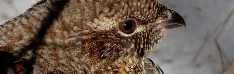

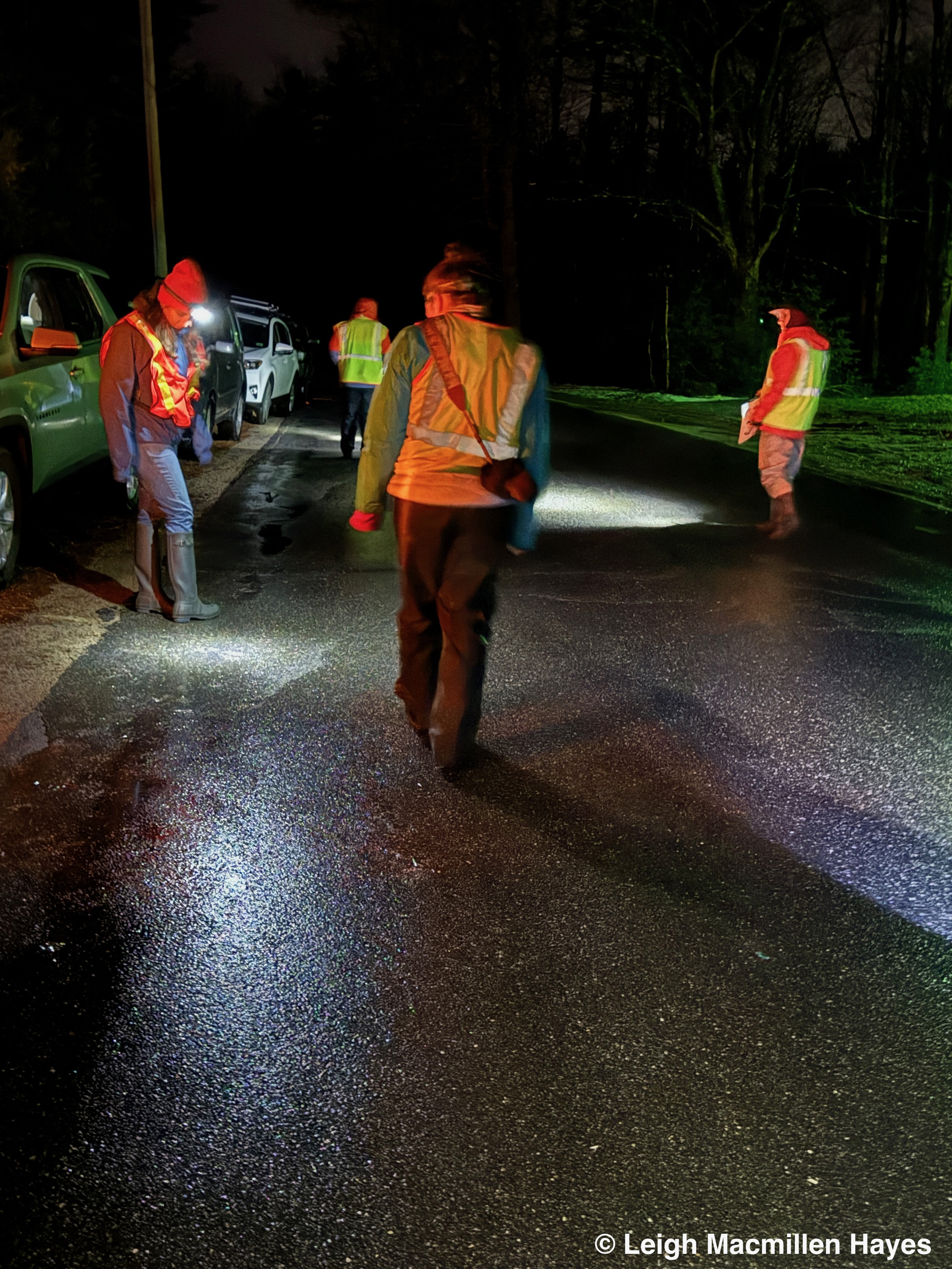
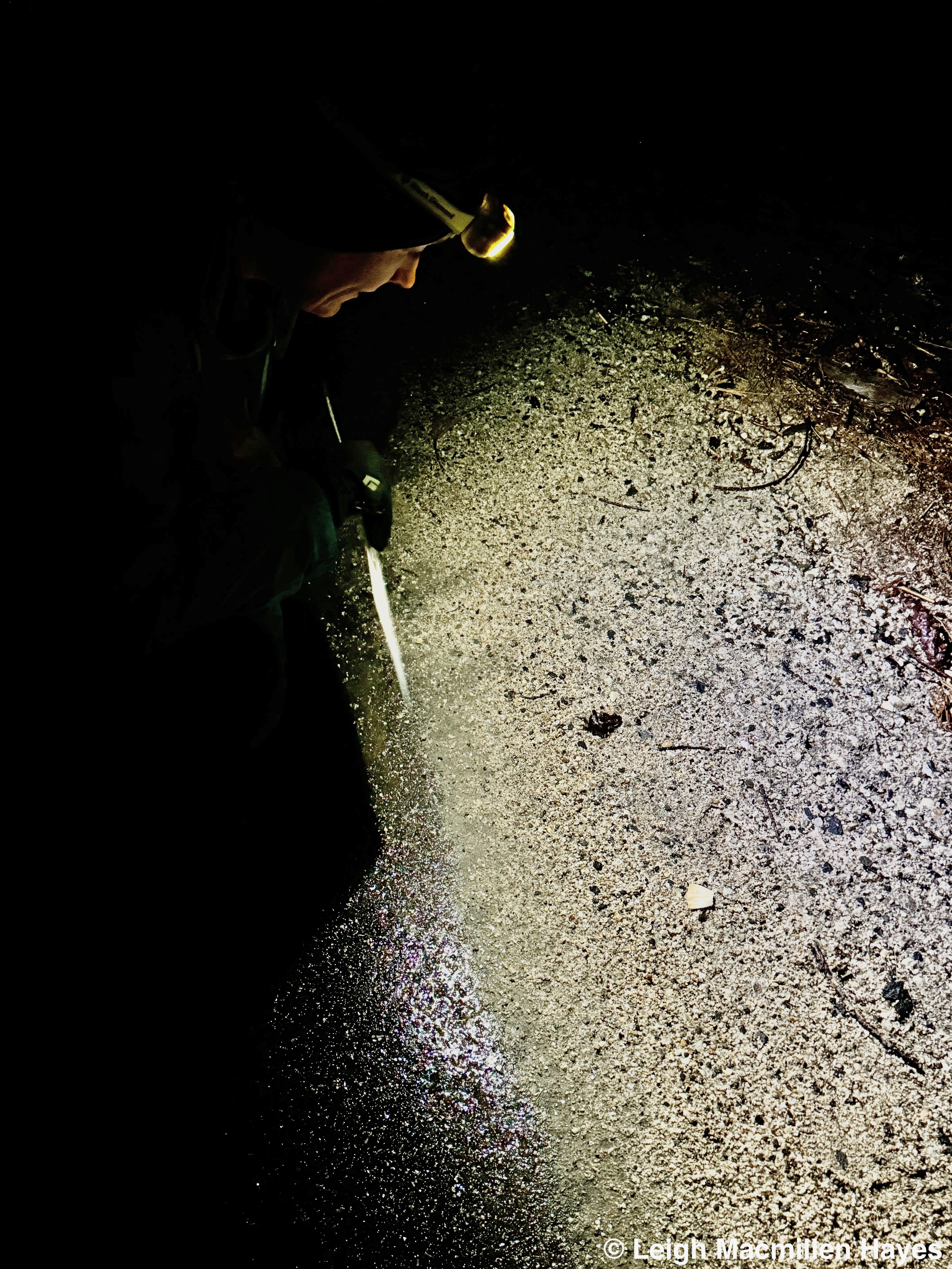
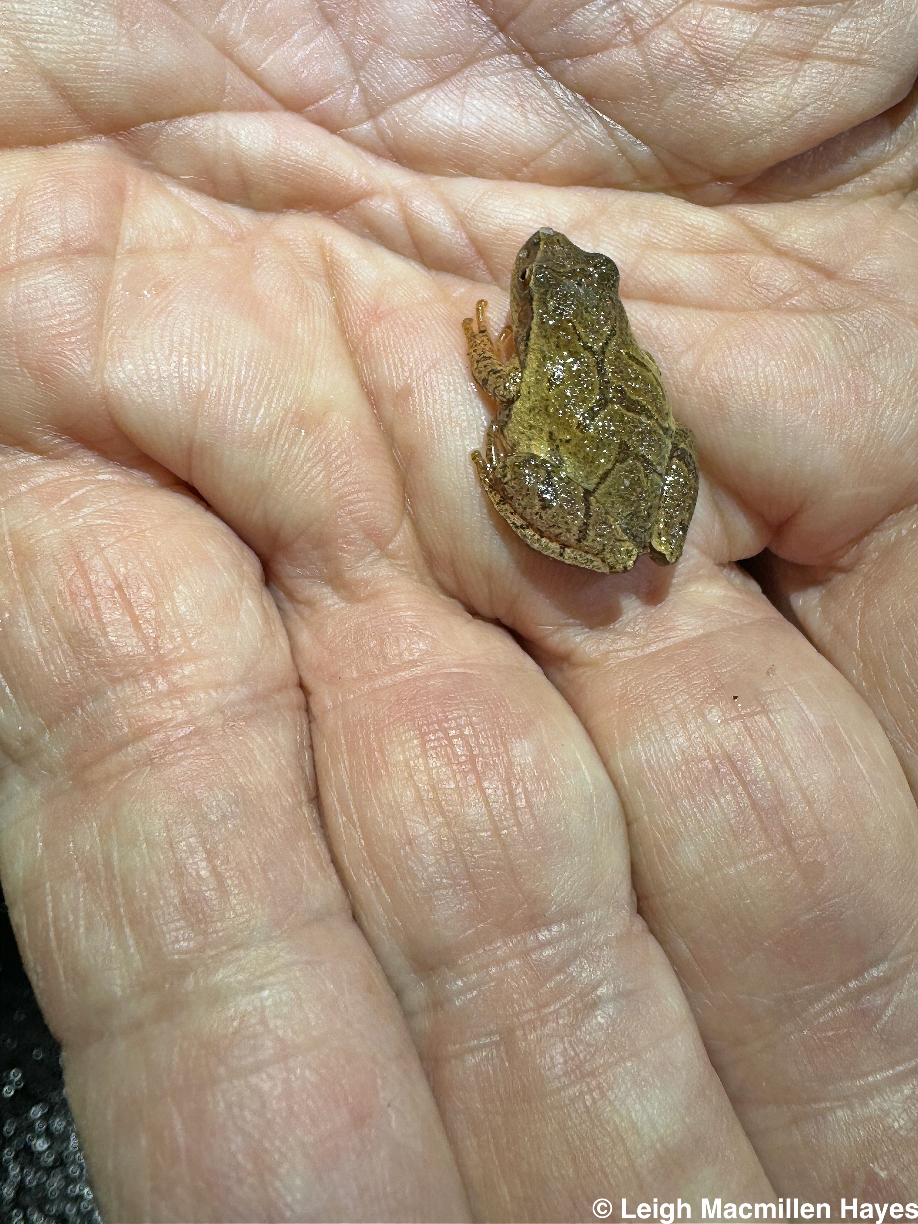
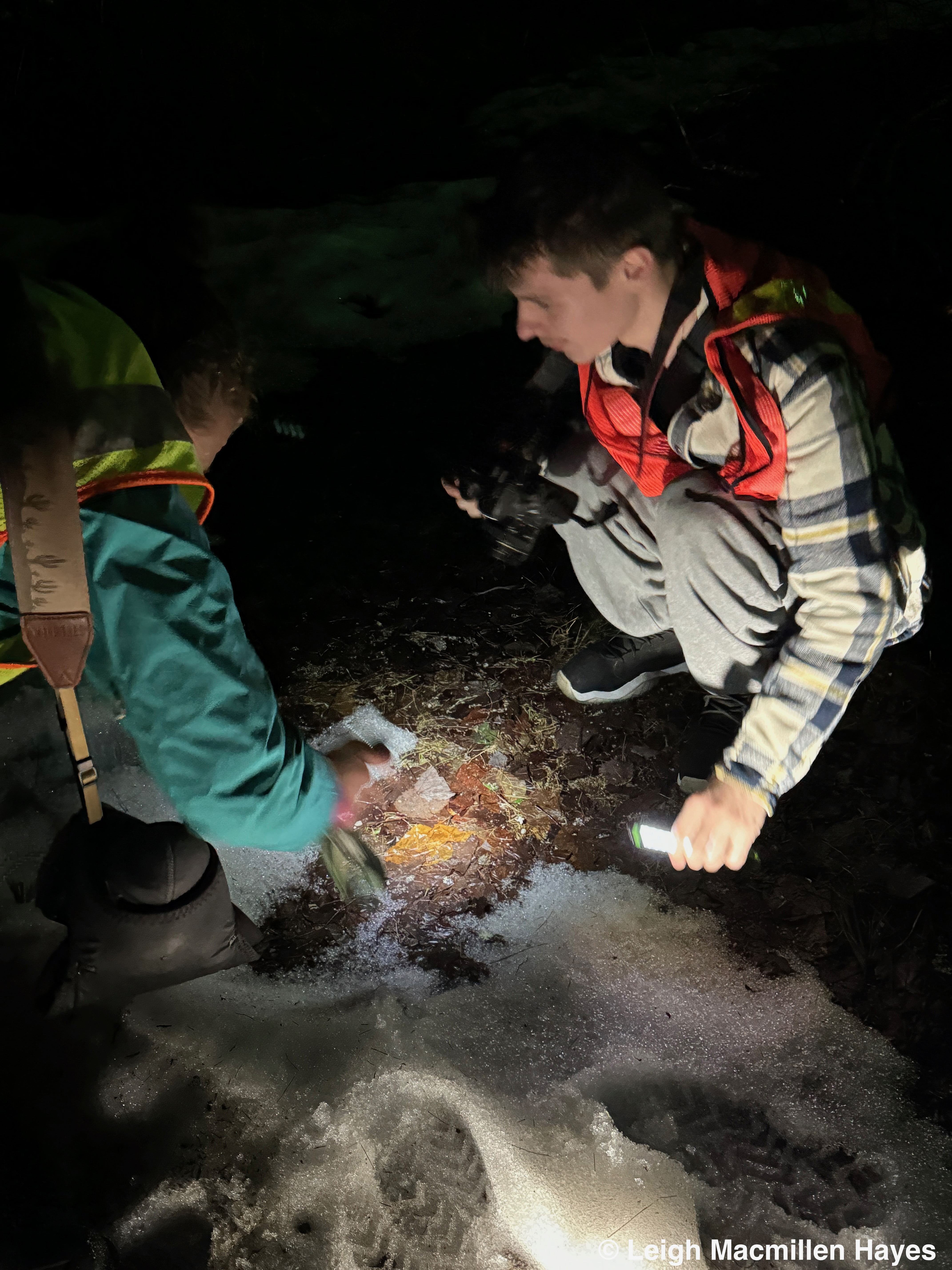
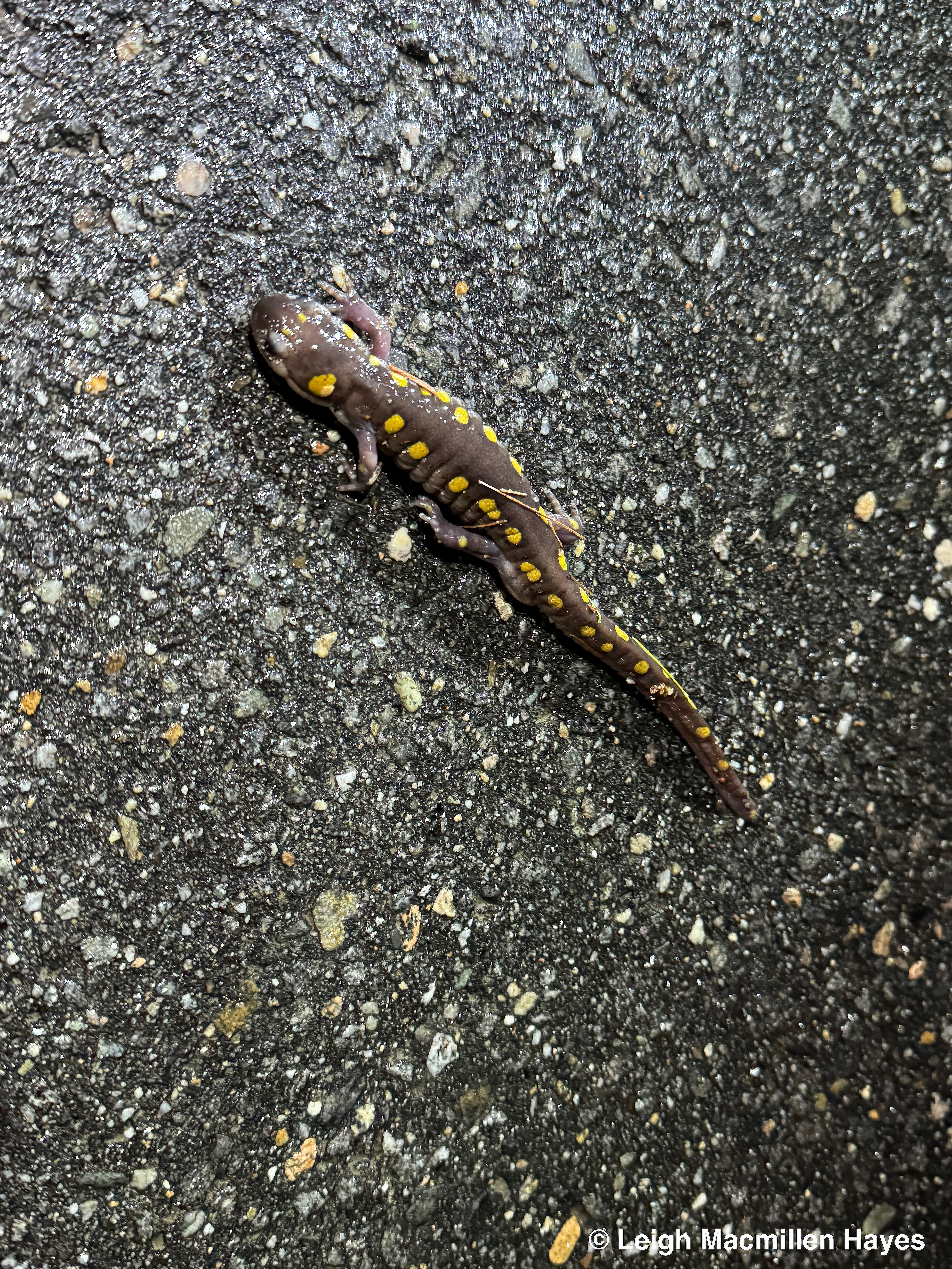
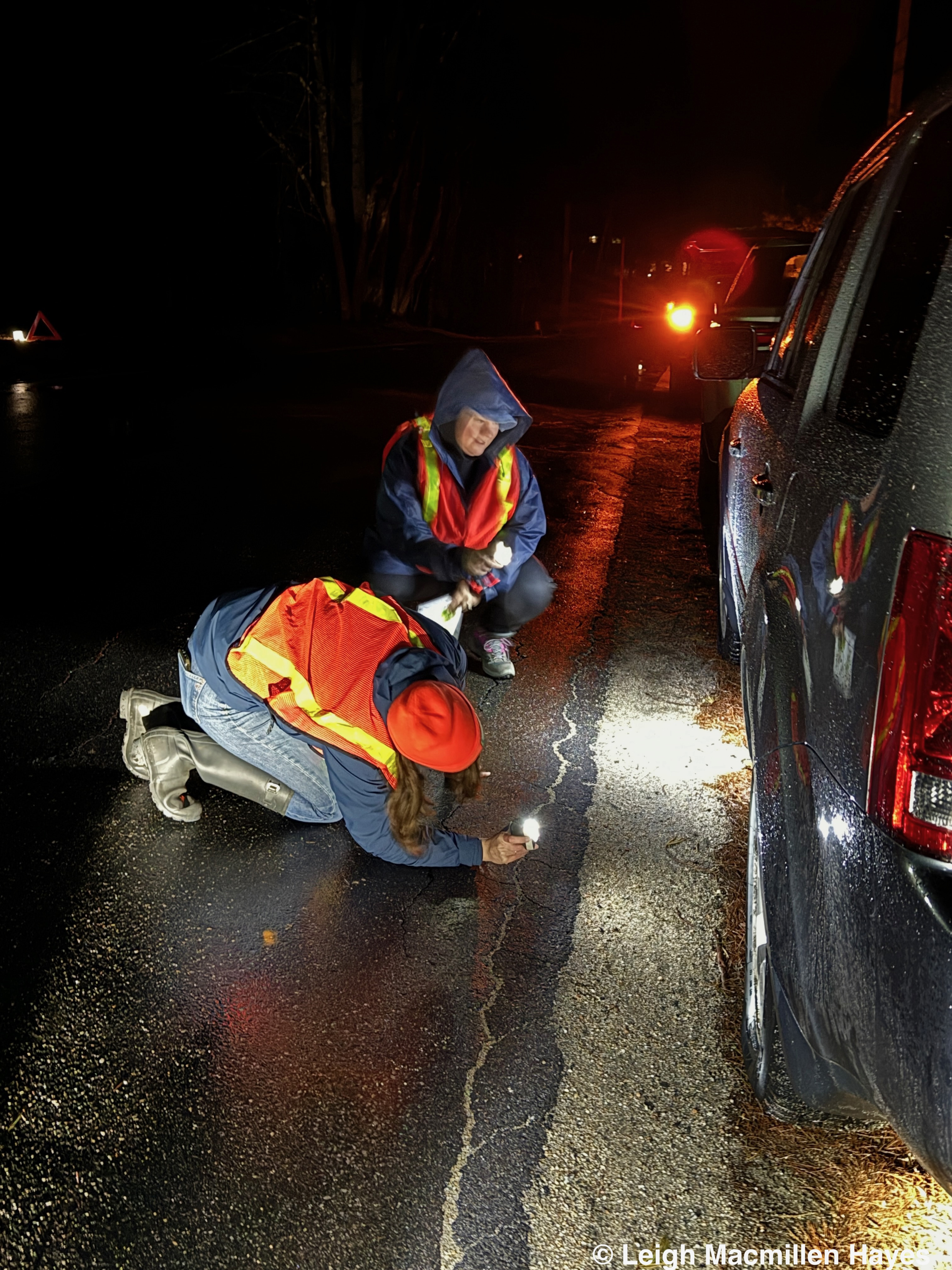
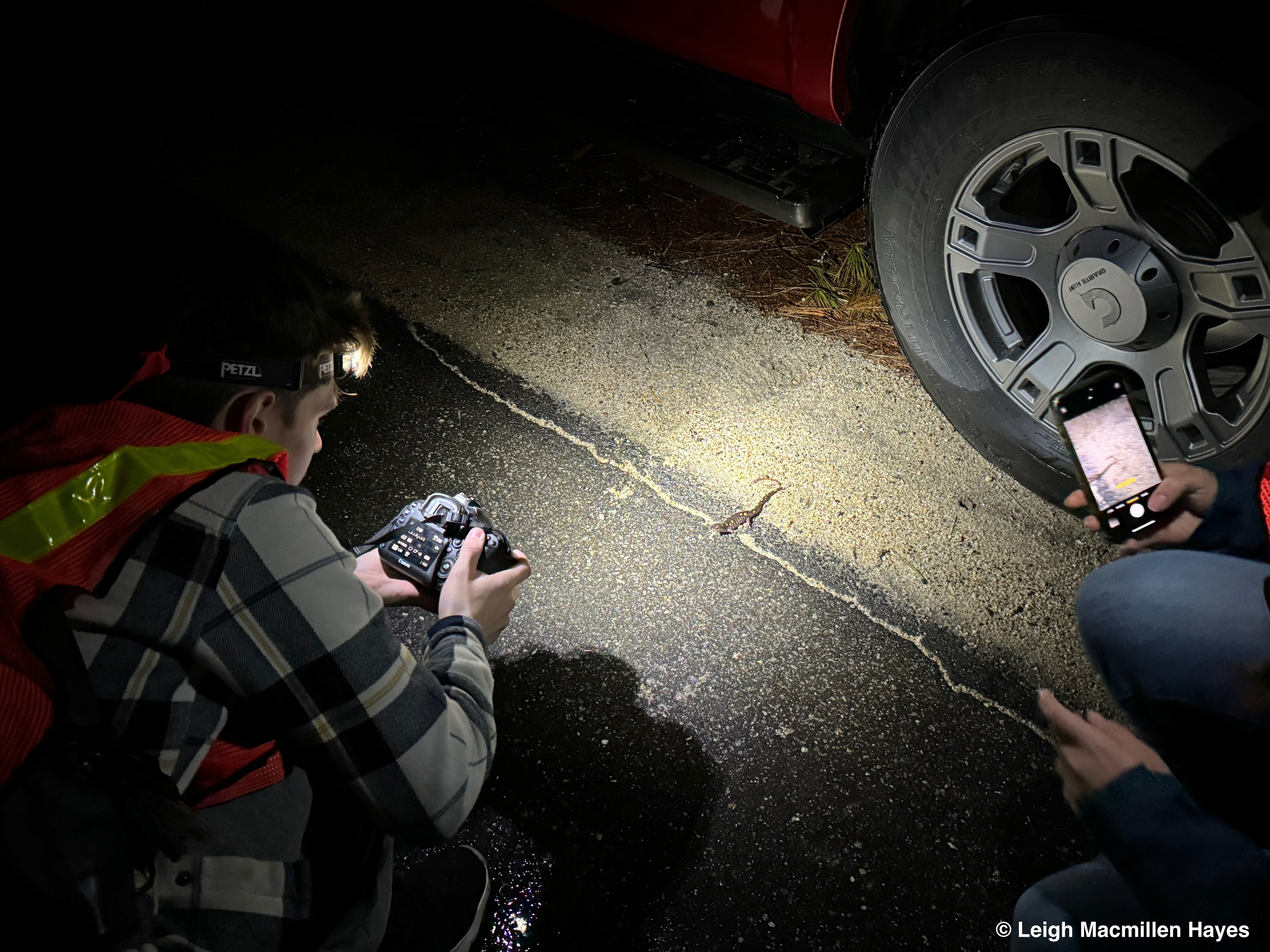
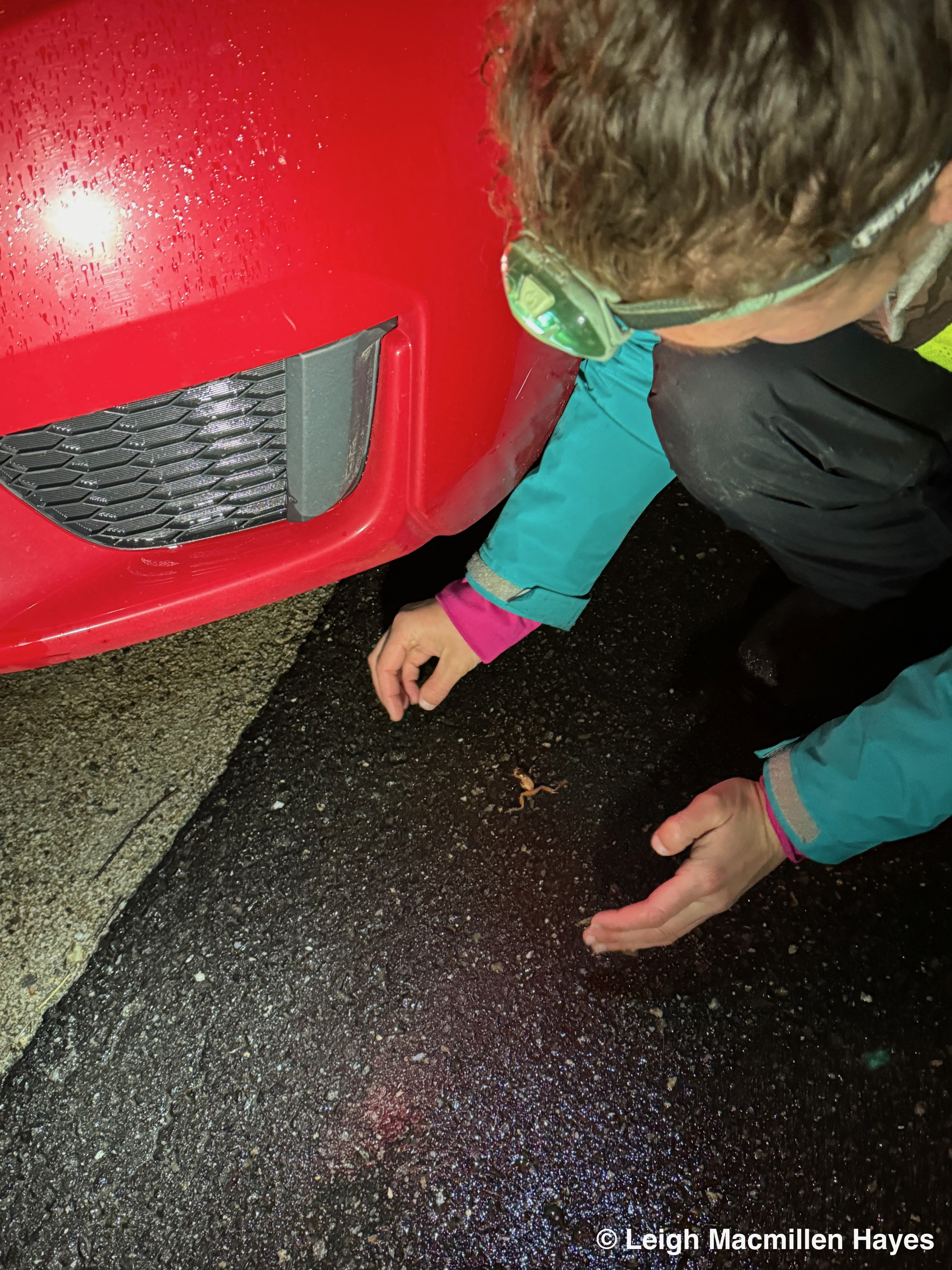
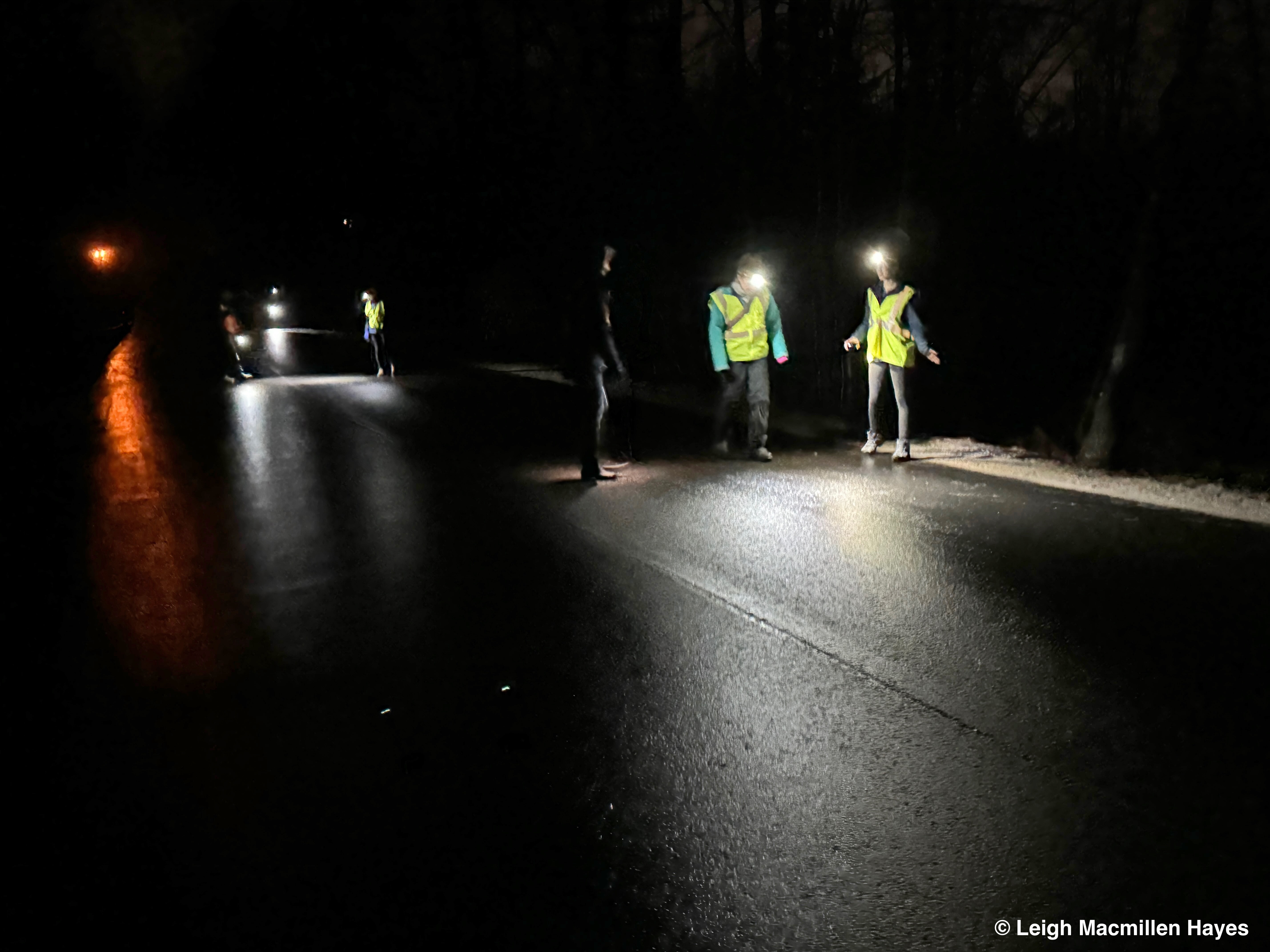
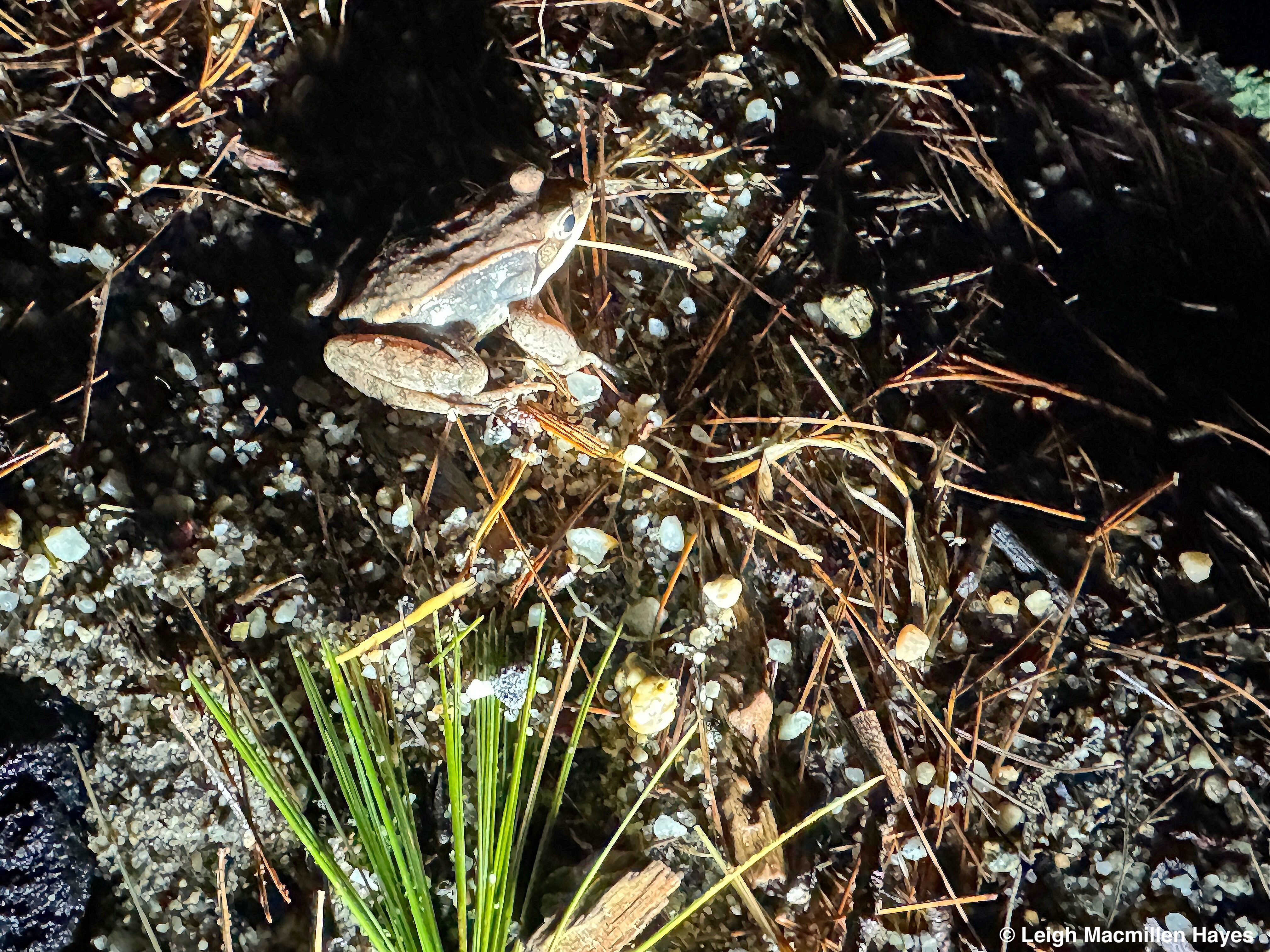

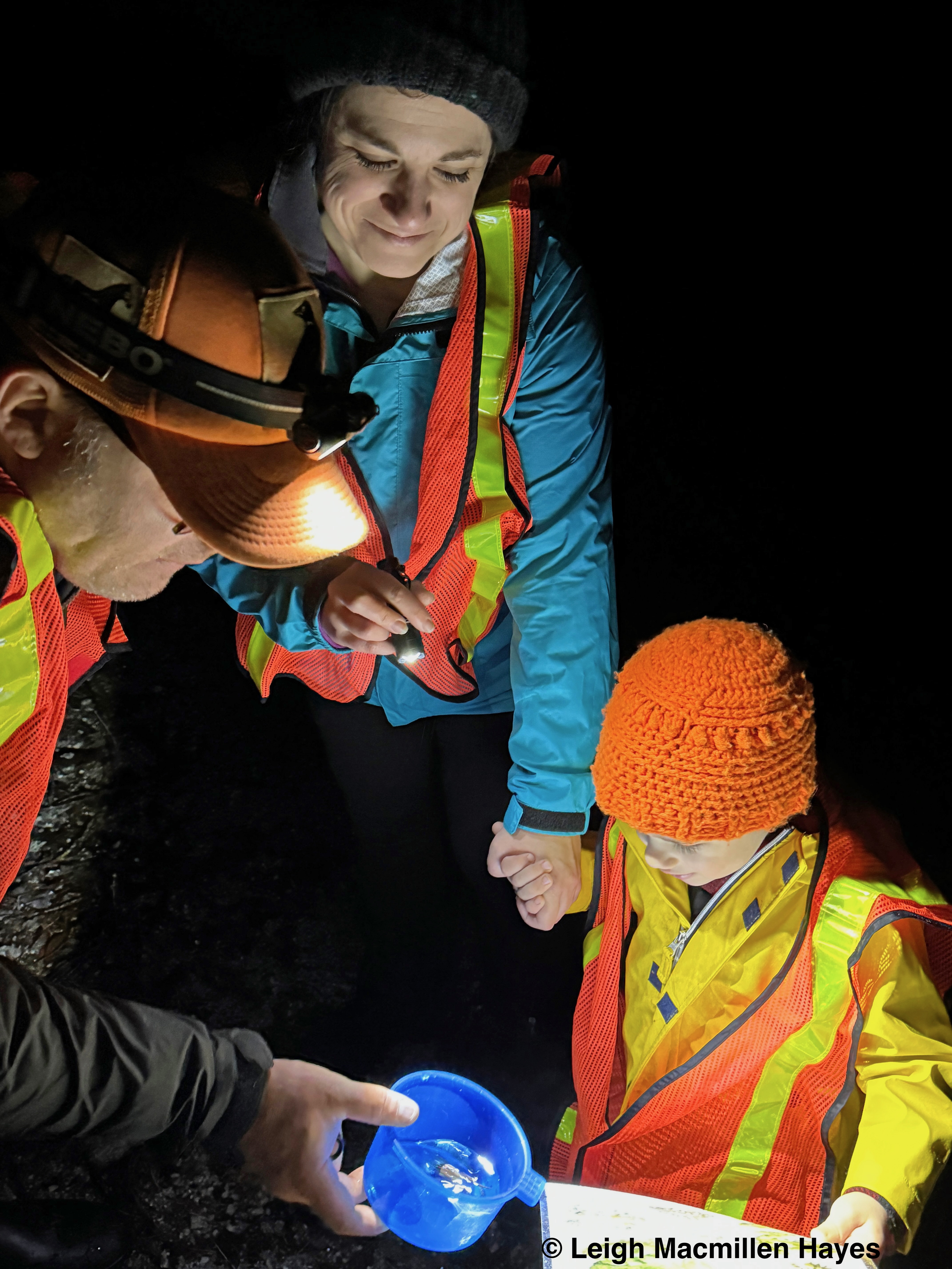
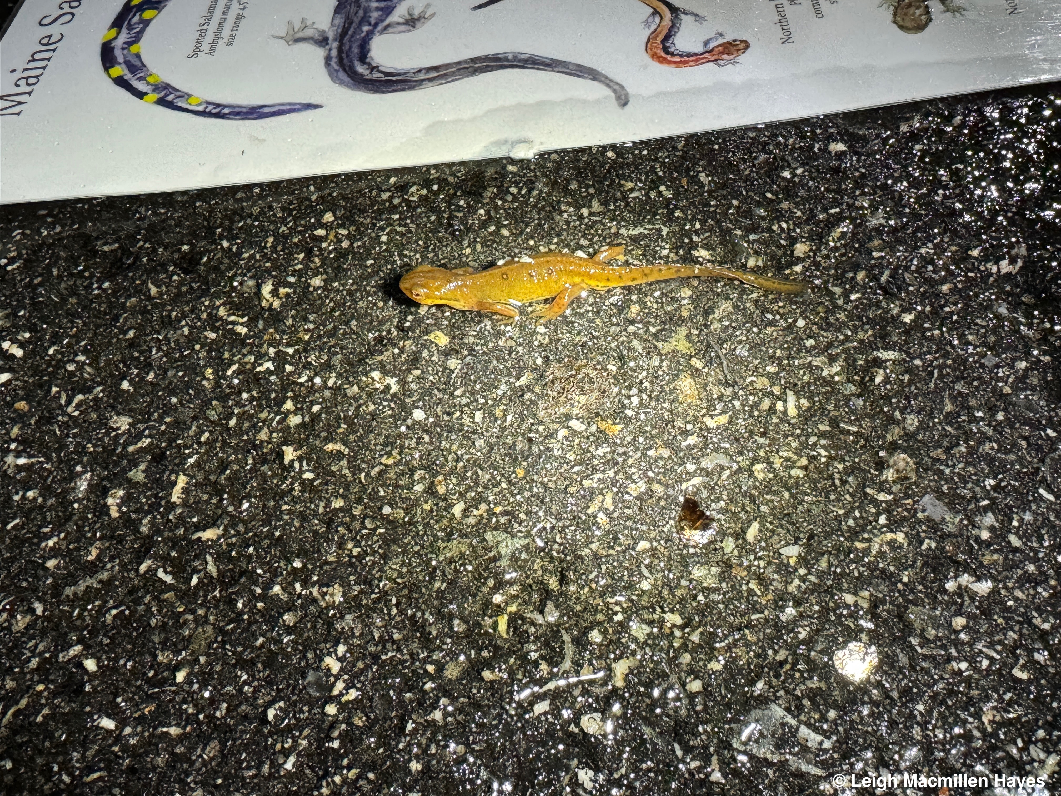
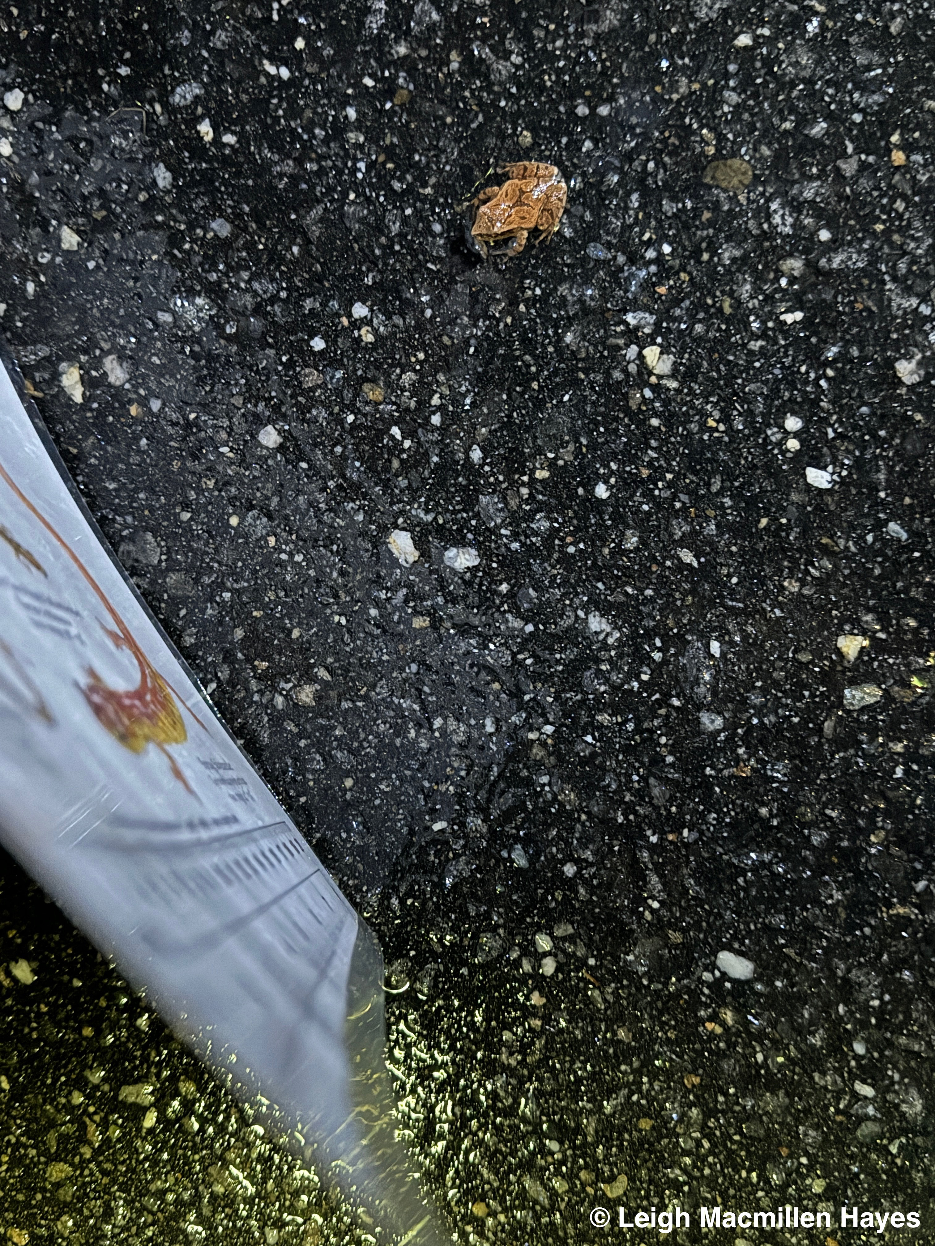
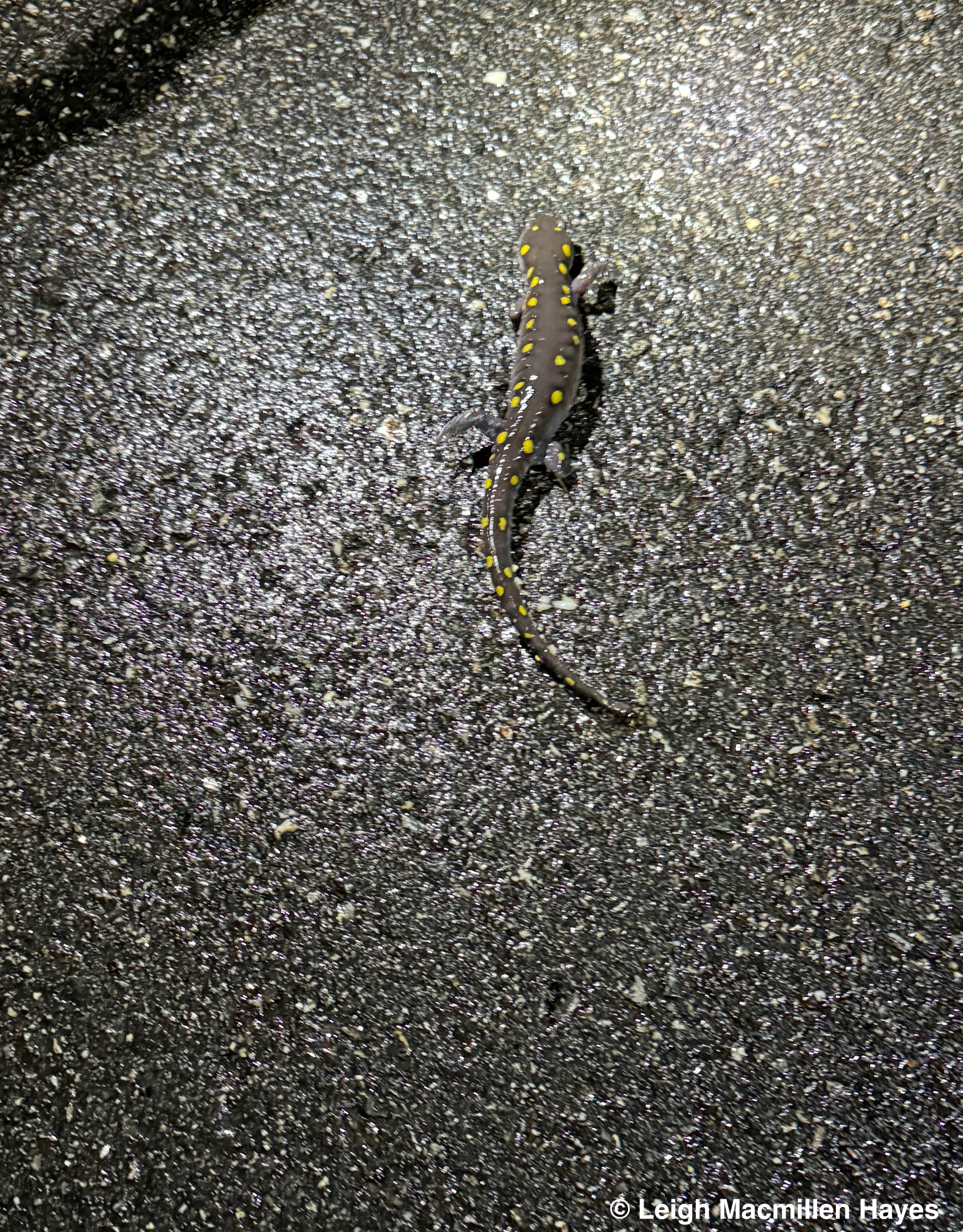
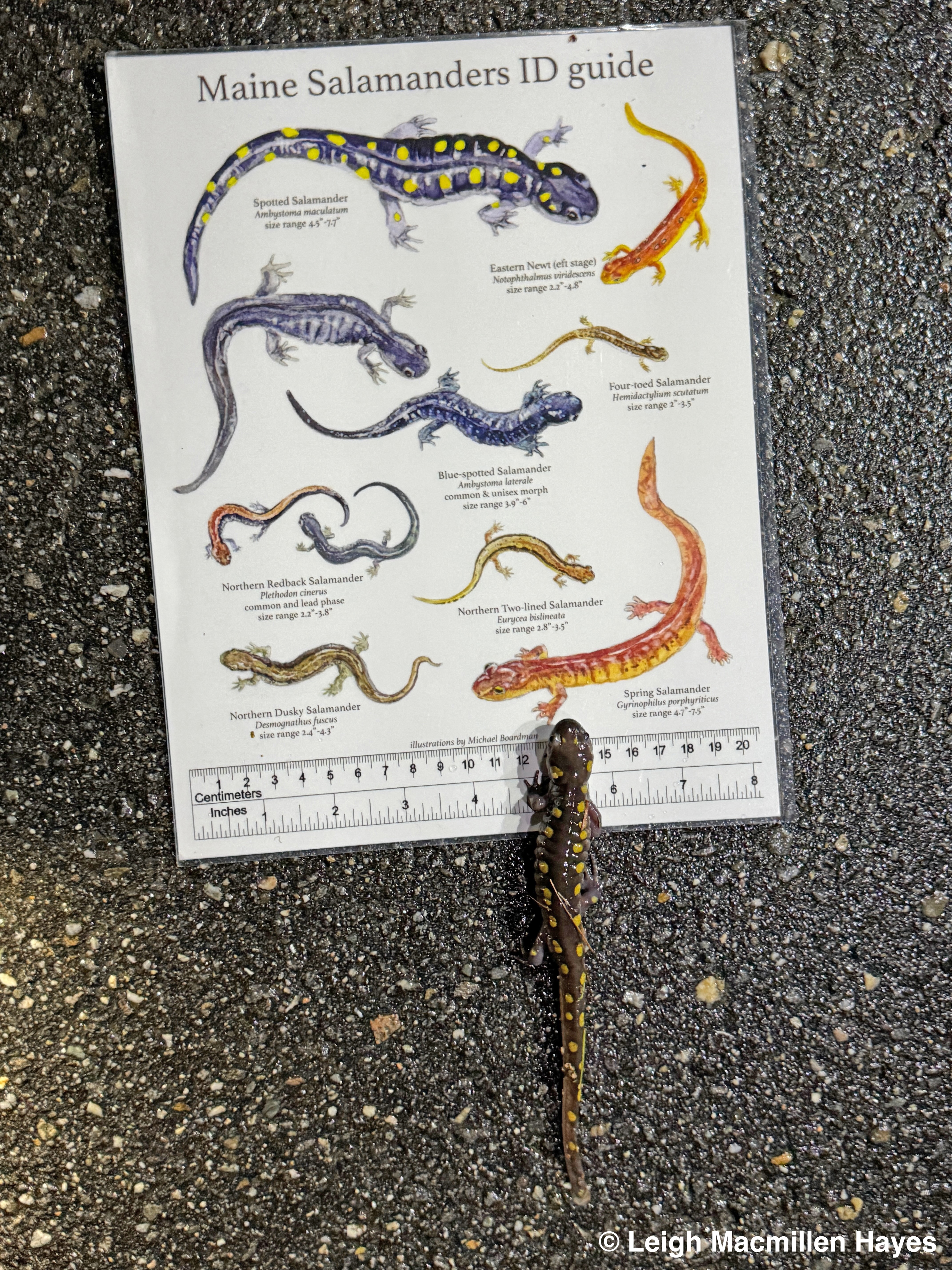
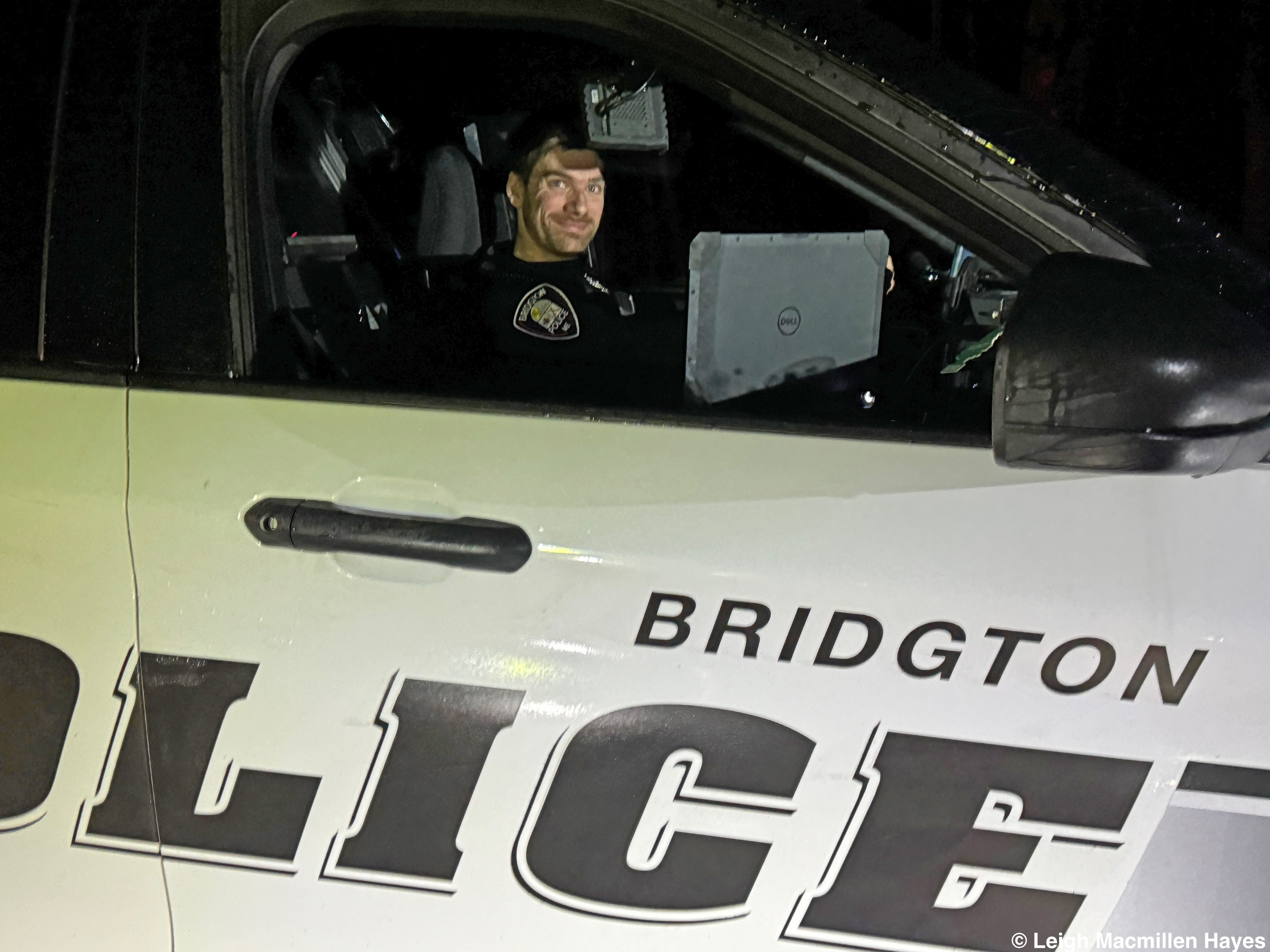
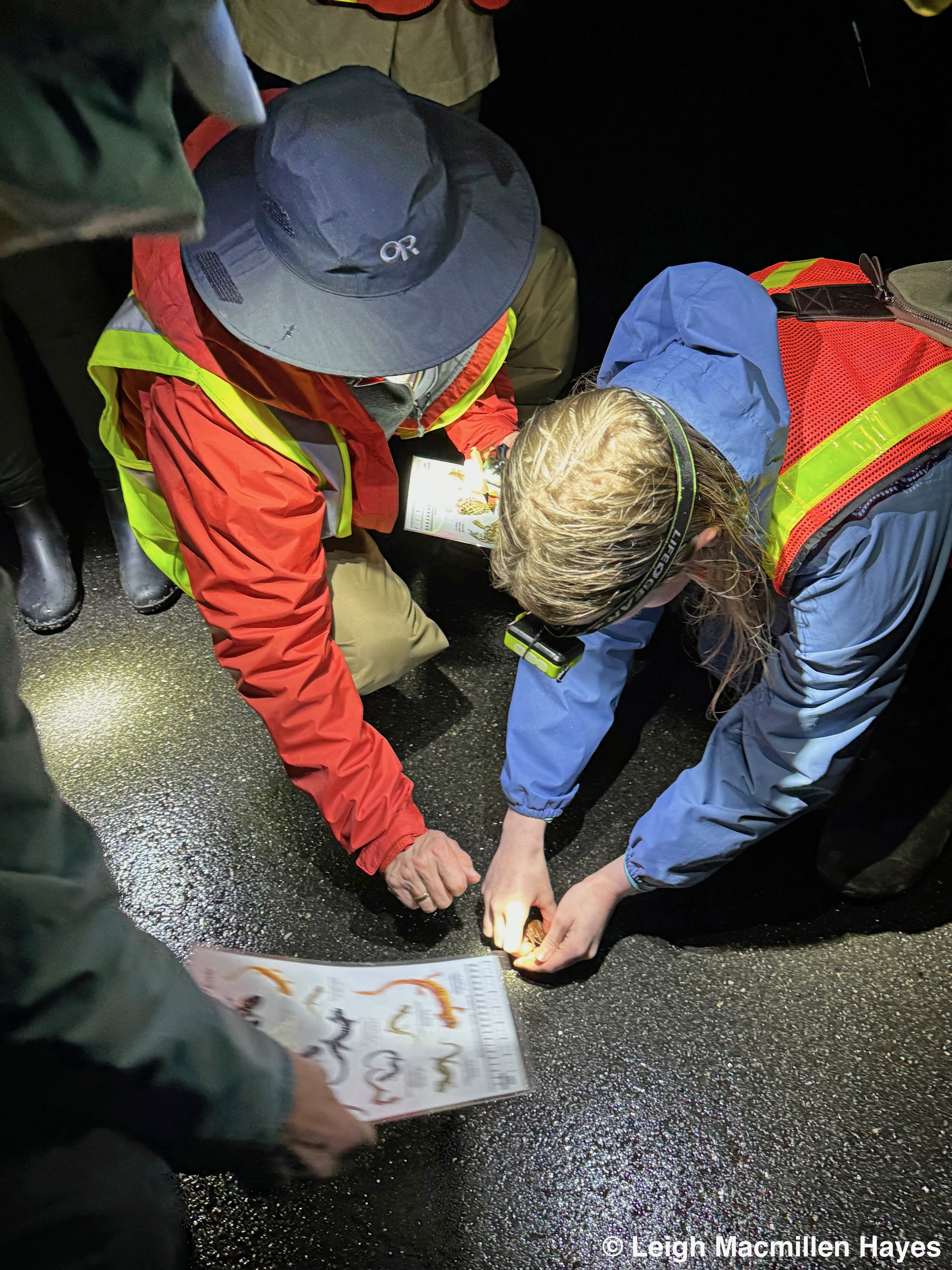
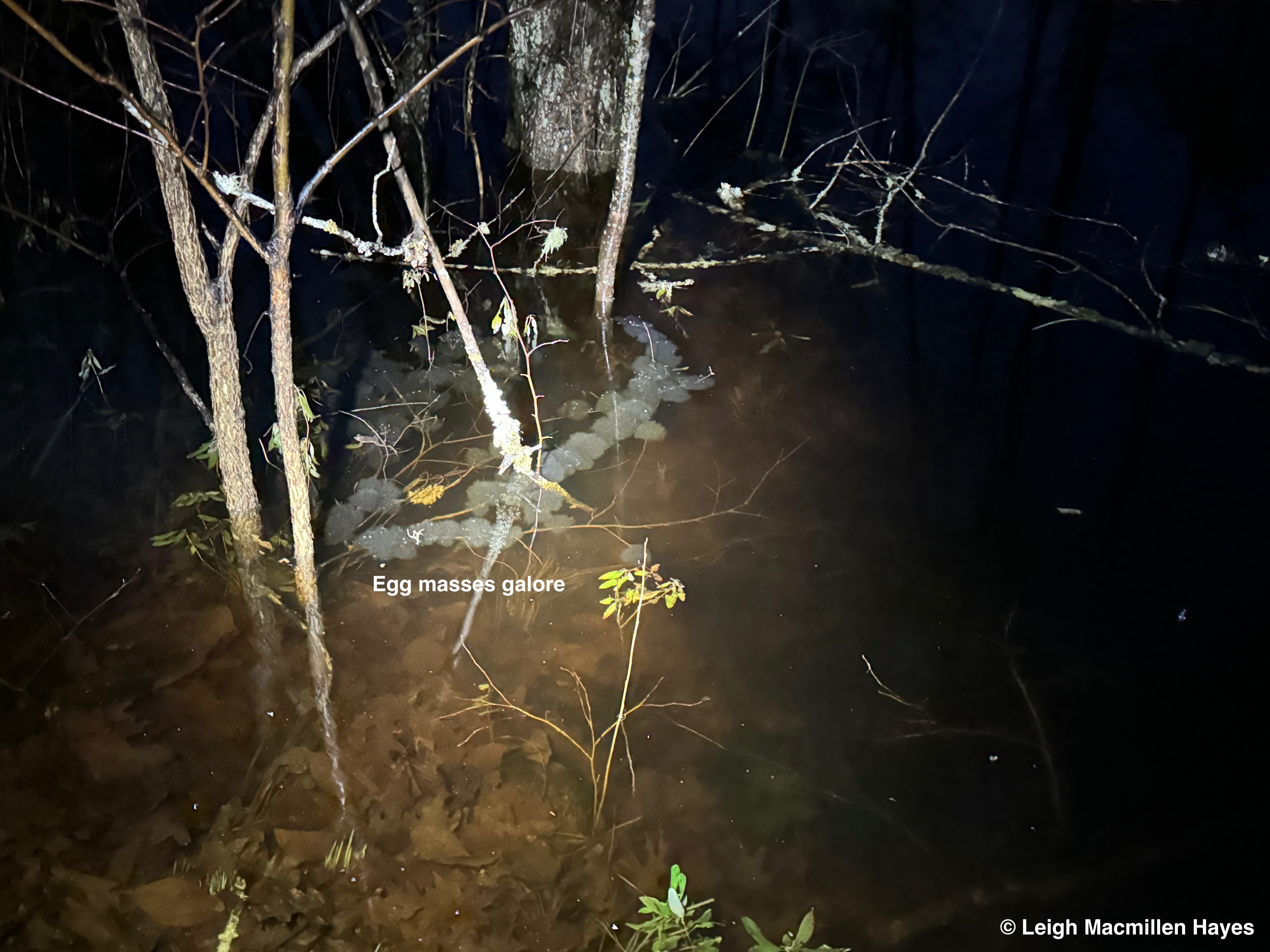
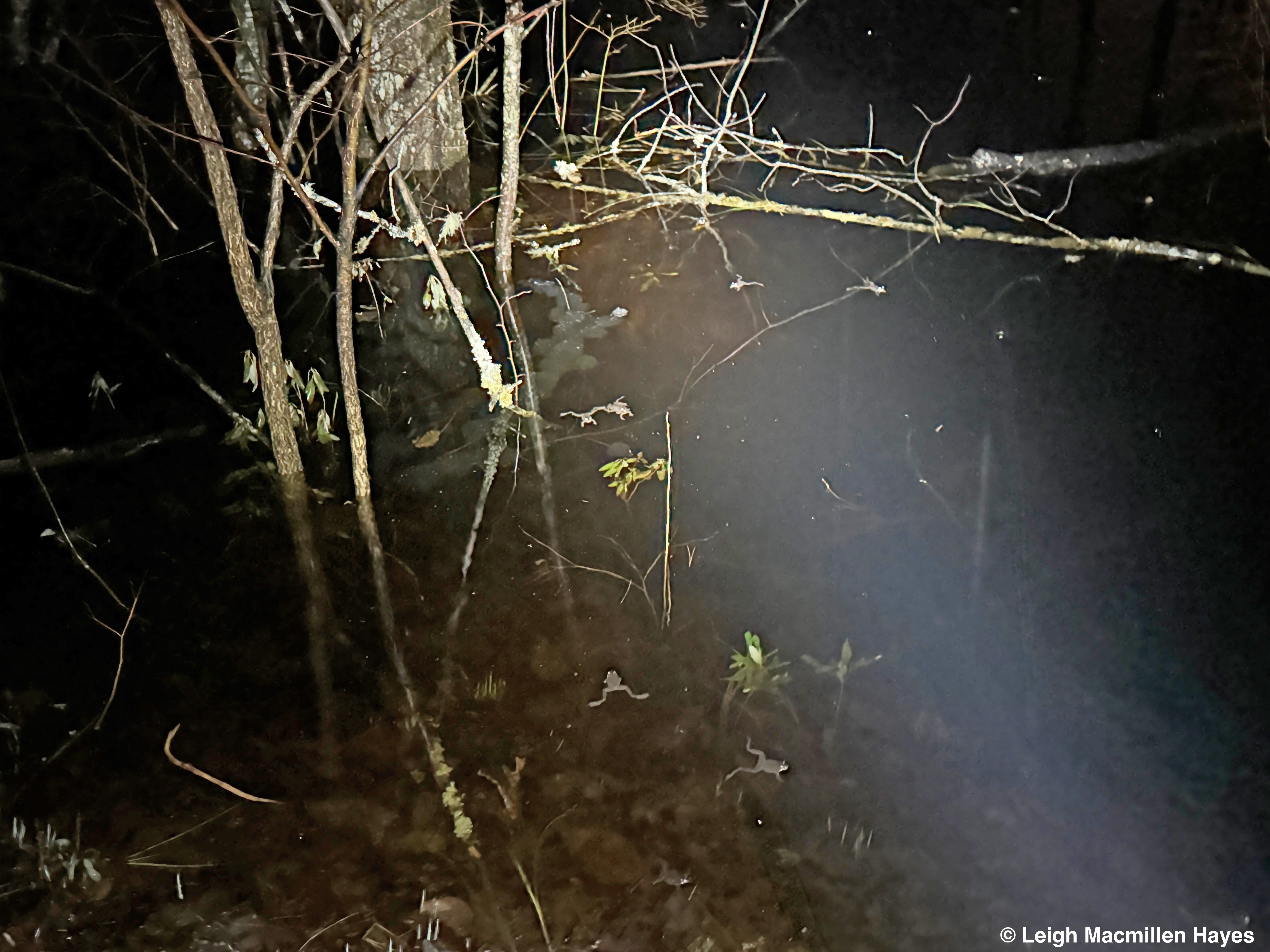
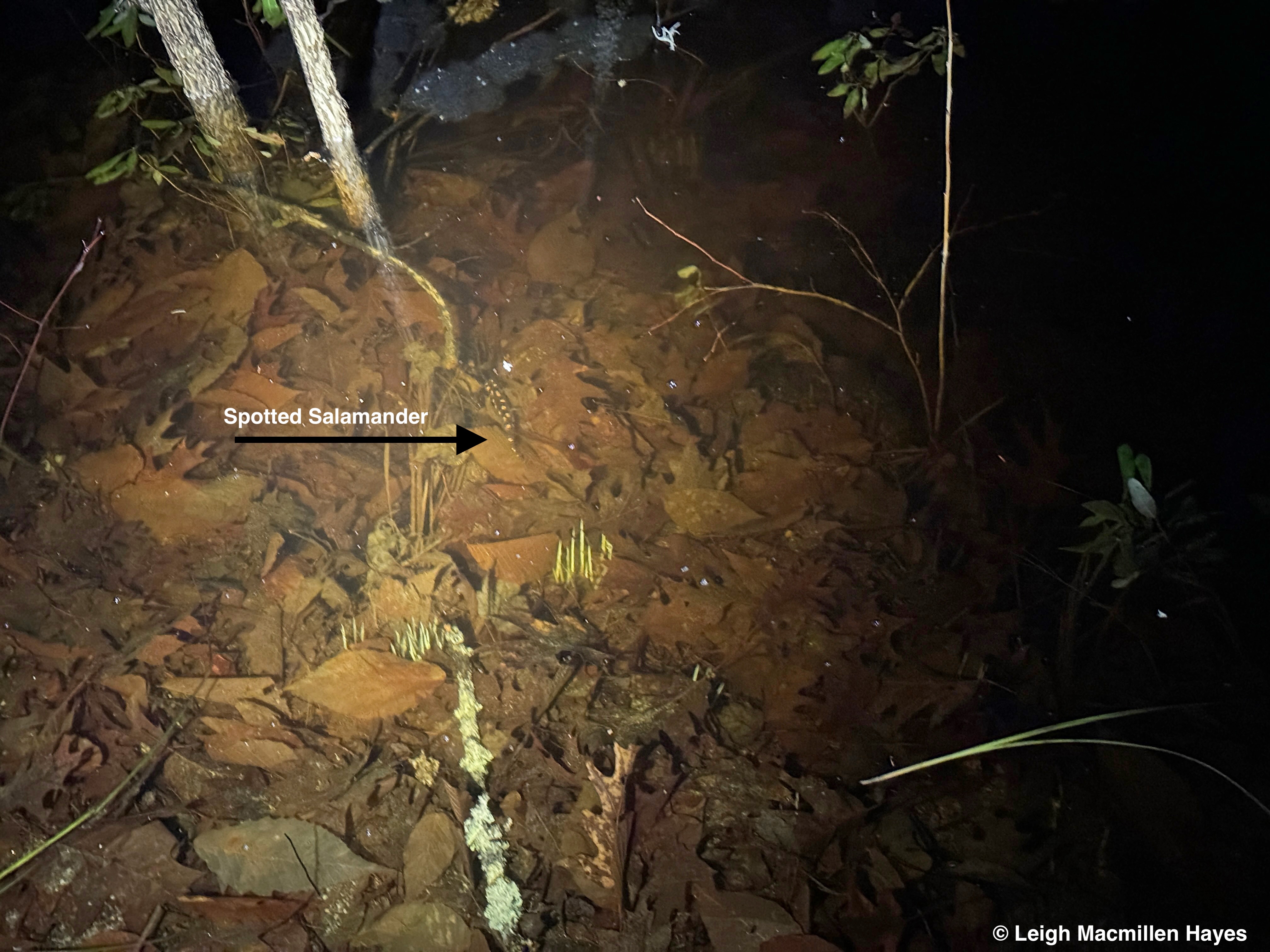
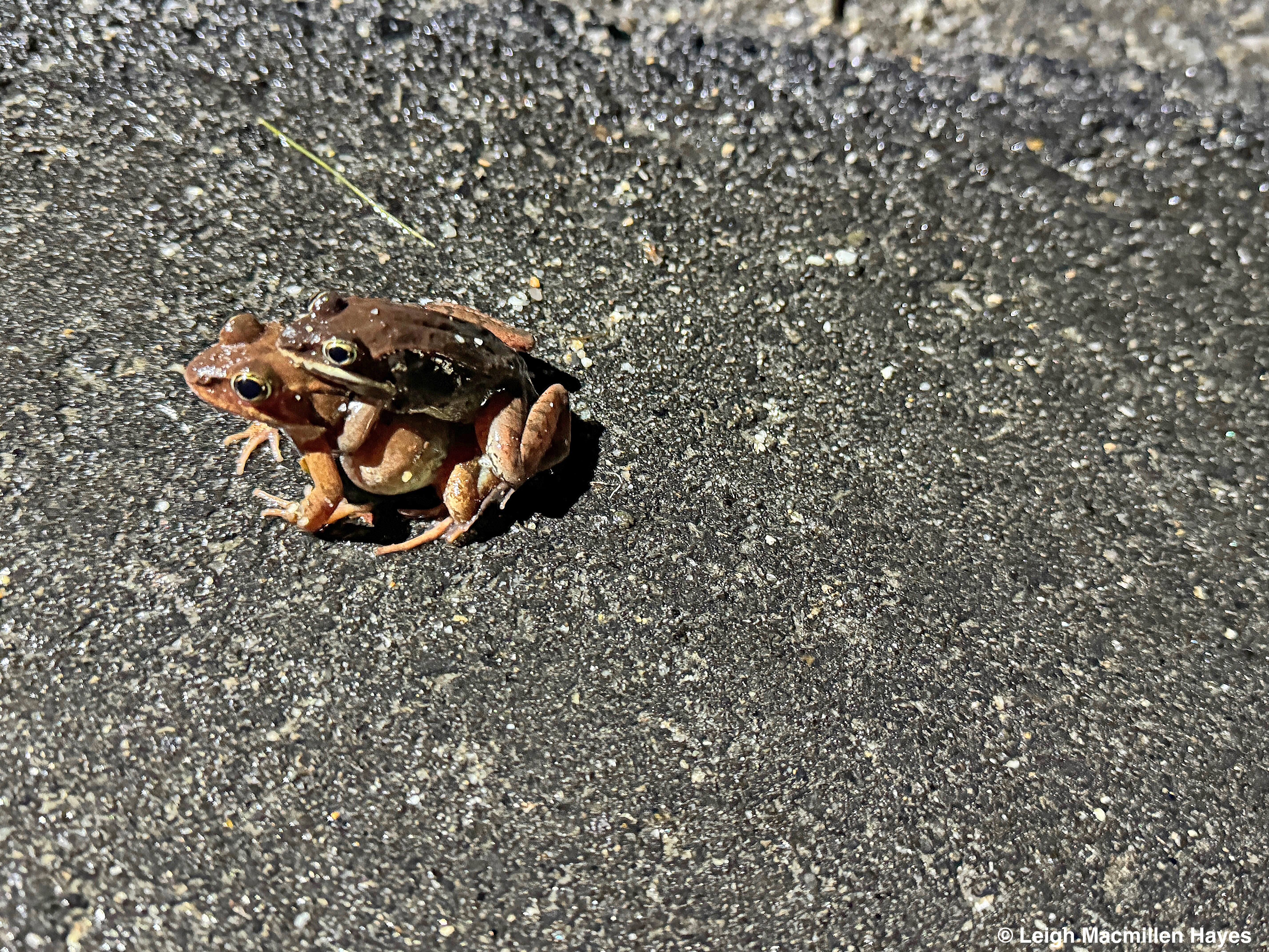
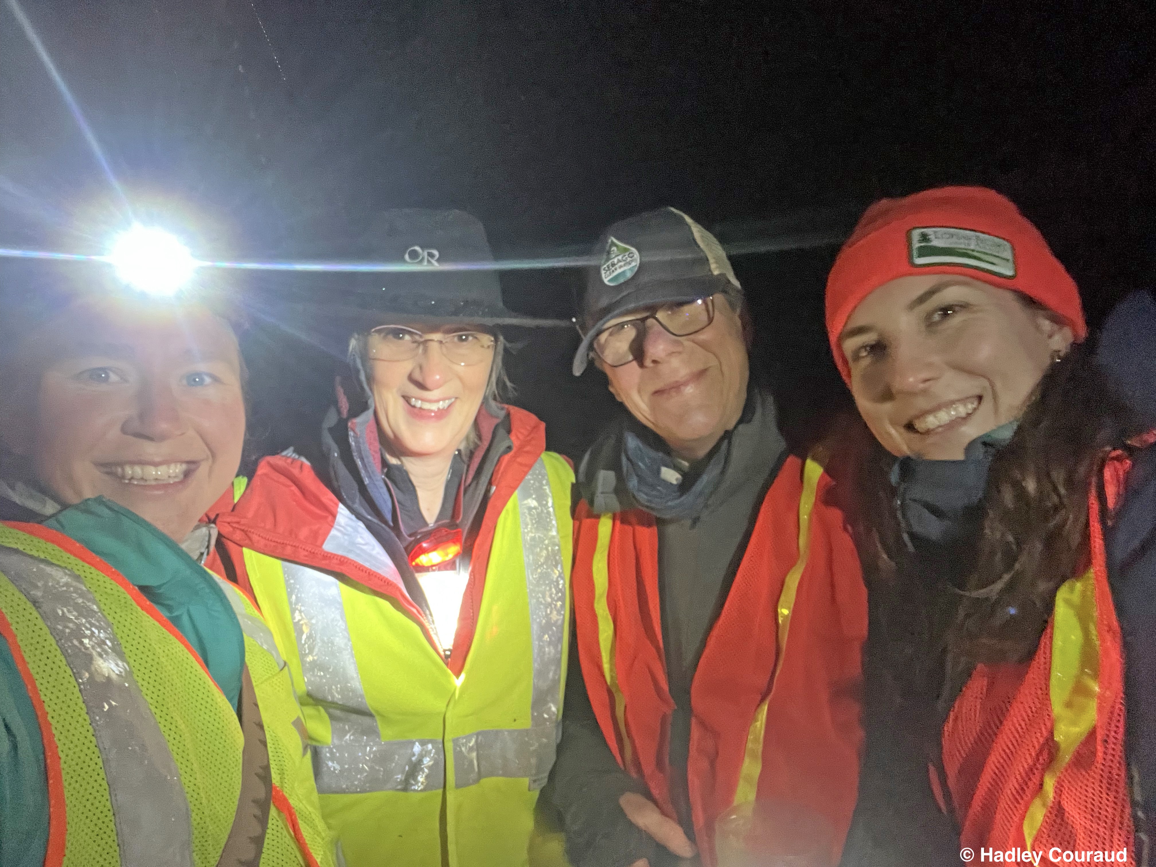


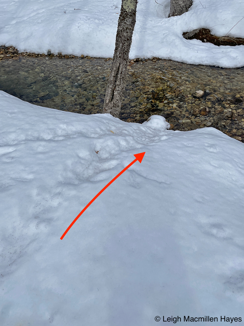


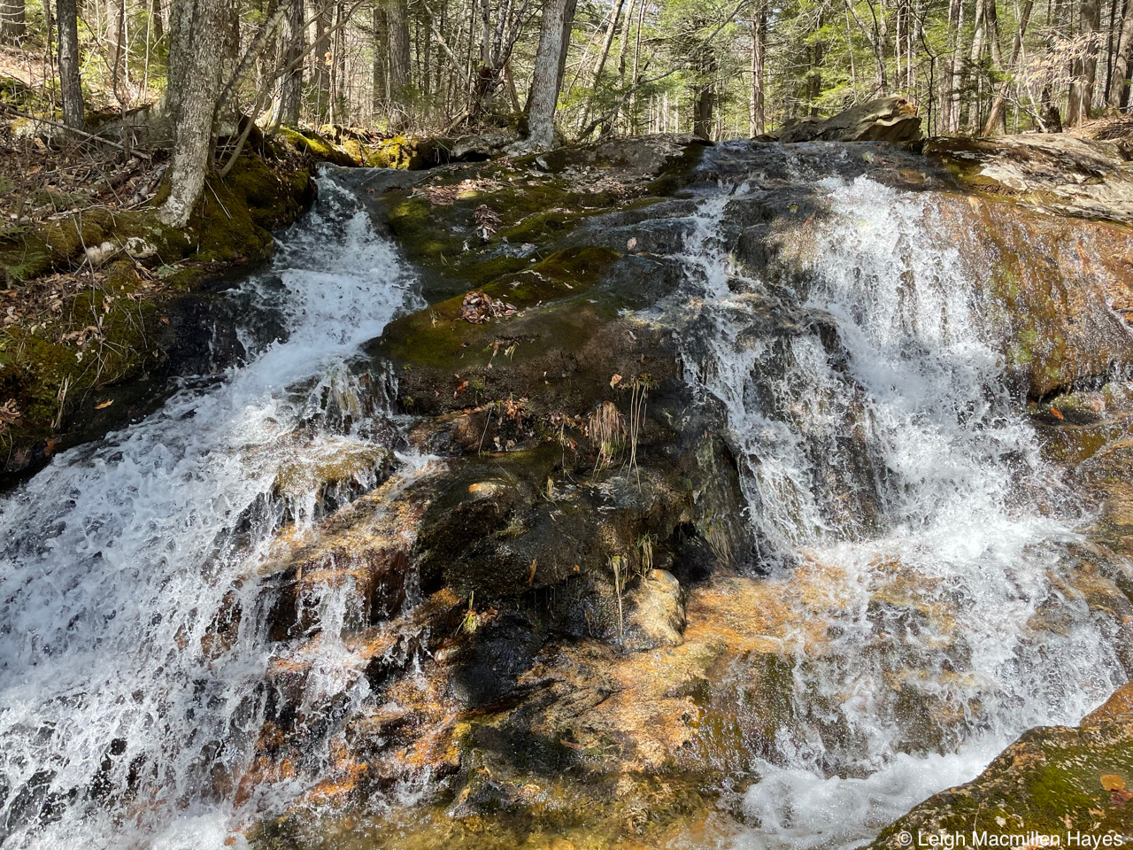


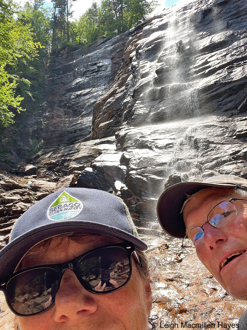


You must be logged in to post a comment.